Two Snow Systems Target Michigan, Illinois, Indiana and Ohio Feb 28–March 2 as Narrow 1–4” Band Sets Up Near I-96 While Second Track Dips Toward Indiana
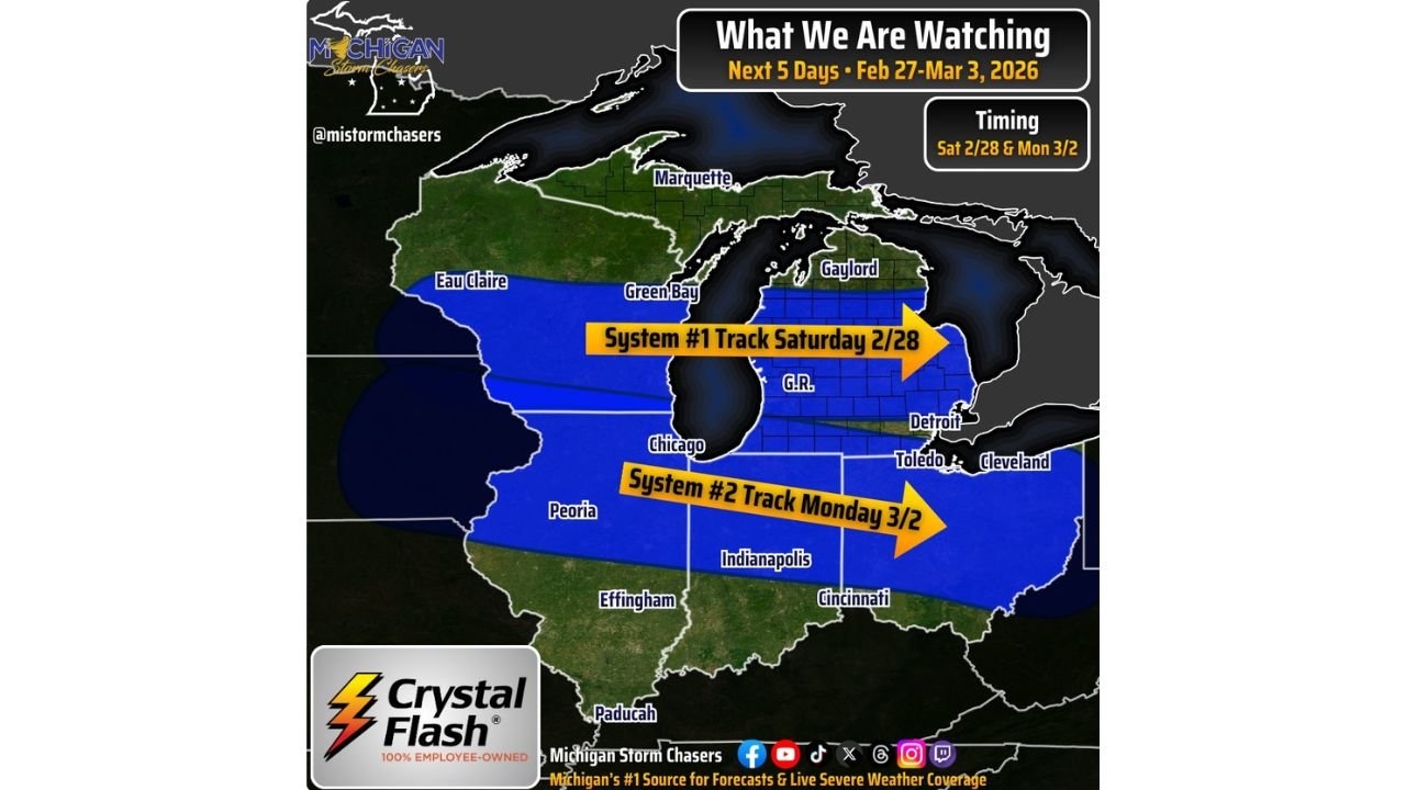
MICHIGAN — We are now within the 7-day window to closely track two incoming snow systems expected to move through the Great Lakes between Saturday, February 28 and Monday, March 2, 2026. Current projections show both systems favoring snow over other precipitation types, though each will take a different path.
The setup features northwest flow — the same pattern that helped deliver a snowy stretch earlier this winter — but subtle jet stream shifts will steer each system on separate tracks.
System #1: Saturday Afternoon Snow Band Across Lower Michigan
The first system arrives Saturday (2/28) and is expected to lay down a thin but organized swath of snow, primarily across the Lower Peninsula of Michigan.
Forecast details indicate:
- 1–3 inches common
- Isolated totals up to 4 inches
- Snow band potentially no wider than 100 miles
The most likely corridor for accumulating snow includes:
- I-96 from Muskegon to Lansing
- I-69 from Lansing north toward the Canadian border
- Areas near Grand Rapids (G.R.)
- Toward Detroit and Toledo on the eastern edge
Outside the central band, lighter totals around 1 inch or less are expected.
Cities shown near or within the projected band include:
- Grand Rapids
- Lansing
- Detroit
- Toledo
- Northern sections near Gaylord
Meanwhile, northern Michigan — including Marquette — appears outside the primary accumulation zone for this first system.
However, forecasters caution the track remains subject to change, especially given the narrow width of the snowfall corridor.
System #2: Monday Track Dips South Toward Indiana and Ohio
The second system, projected for Monday (3/2), is currently modeled farther south.
This system may:
- Dip south of I-94
- Shift the main plowable snow band into Indiana
- Potentially extend into Ohio
Key cities within the projected southern track include:
- Chicago
- Indianapolis
- Cincinnati
- Portions of western Ohio
Some areas just south of I-94 in Michigan could be clipped by the northern edge, but early guidance favors the heaviest snow staying across central Indiana into Ohio.
Unlike the first system, this second disturbance has shown more variability in recent model runs, meaning a northward shift remains possible.
Two Different Tracks, Two Different Impacts
At this stage:
- System #1 favors Lower Michigan Saturday
- System #2 favors Indiana and Ohio Monday
The spacing between the two systems means impacts will be separate events rather than a single prolonged storm.
If the second system wobbles north, portions of southern Michigan could see more significant totals early next week. If it stays south, the heaviest snowfall remains concentrated from Illinois through Indiana into Ohio.
What This Means for Chicago and the Midwest
For Chicago, the primary snow opportunity appears tied to Monday’s system, depending on the exact southern track.
For Detroit and central Lower Michigan, Saturday remains the better chance for accumulating snow.
For Indianapolis and Cincinnati, Monday currently presents the stronger snow signal.
With meteorological spring approaching, these systems could serve as one of the final measurable snow events of the season for many communities.
Bottom Line
Two separate systems are lined up:
- Saturday (2/28): Narrow 1–4” band across Lower Michigan
- Monday (3/2): Southern track across Illinois, Indiana and Ohio
Track adjustments are still possible, especially with the second system, but snow remains the dominant precipitation type for both setups.
Stay with ChicagoMusicGuide.com for continuing updates as models refine the exact snowfall corridors across Michigan and the Midwest.