Mid-March Cold Comeback Targets Illinois, Indiana, Ohio and the Great Lakes as “Fake Spring” Fades Fast
UNITED STATES — Just as early March warmth begins teasing parts of the country with springlike conditions, new ensemble guidance is trending noticeably colder for mid-March — especially across the Midwest, Great Lakes, and Ohio Valley.
The message from long-range model comparisons is clear: the recent mild stretch may not last.
Colder Air Expands Across the Midwest and Great Lakes
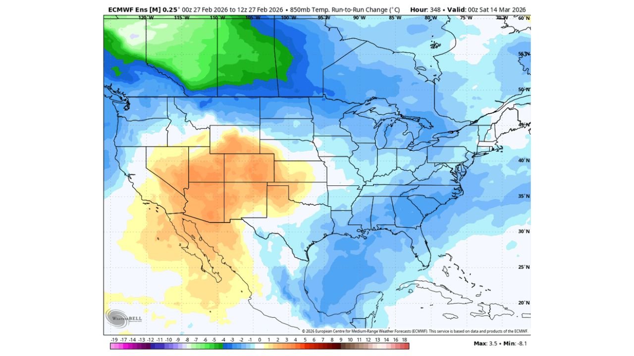
Latest ensemble run-to-run changes valid around March 14 show a broad area of cooling spreading across:
- Illinois
- Indiana
- Ohio
- Michigan
- Wisconsin
- Pennsylvania
- Upstate New York
- Portions of the Mid-Atlantic
Both surface (2-meter) and 850mb temperature projections show consistent blue shading — indicating a colder shift compared to prior forecasts.
This isn’t just a minor adjustment. The trend suggests:
- Below-normal temperature potential
- Reinforcing cold air from central Canada
- A renewed dip in the jet stream across the central and eastern U.S.
Chicago Region: A Sharp Reality Check?
For Chicago and northern Illinois, the updated guidance signals a noticeable cooling trend by mid-month.
If this pattern verifies, the region could see:
- Daytime highs trending back toward late-winter norms
- Chilly overnight lows
- Potential for renewed wintry precipitation threats depending on storm tracks
While early March may bring milder air at times, the evolving mid-March pattern suggests winter still has influence left.
Eastern U.S. Also Trends Cooler
Cooling signals extend beyond the Midwest into:
- Kentucky
- Tennessee
- West Virginia
- Virginia
- The Carolinas
- Parts of the Northeast
The ensemble shift indicates that the eastern half of the country may lose its ridge dominance as colder air presses southward.
That aligns with broader pattern hints discussed earlier — that early March warmth may be temporary.
West Warmer, Central and East Colder
Meanwhile, the model trends show warmer anomalies building across:
- California
- Nevada
- Arizona
- Utah
- Western Colorado
This west-warm/east-cool split is a classic late-winter configuration, often tied to a ridge building along the West Coast and troughing downstream across the central and eastern states.
When that setup locks in, colder Canadian air has a pathway southward into the Midwest and Great Lakes.
Why “Fake Spring” May Not Last
Early March frequently brings volatile swings. The strengthening sun angle can create temporary warm-ups, but if the upper-level pattern favors troughing over the East, colder air can return quickly.
Current ensemble trends suggest:
- The mild spell may peak early
- A colder push could reestablish by mid-month
- Temperature forecasts are adjusting downward compared to previous runs
While exact magnitudes remain uncertain this far out, the directional trend toward cooler conditions is consistent across multiple layers of the atmosphere.
Bottom Line for Illinois and Surrounding States
If you’re enjoying early March warmth across Illinois, Indiana, Ohio, and the Great Lakes, don’t pack away the winter gear just yet.
Mid-March may bring:
- A sharp temperature drop
- Reinforced late-season chill
- Possible renewed storm track shifts
Spring is trying to gain ground — but winter may have one more say before the season fully turns.
Stay with ChicagoMusicGuide.com for continuing updates as mid-March trends come into sharper focus.