Baltimore Swings from 50s to 30s as Strong Cold Front Triggers Snow, Sleet and Freezing Rain Risk Monday Night into Tuesday
BALTIMORE, MARYLAND — A dramatic temperature swing is setting up across the Mid-Atlantic, with Baltimore enjoying springlike warmth this weekend before a sharp cold front flips the script early next week.
Highs are expected to climb into the 50s through Sunday, but by Monday temperatures could tumble into the 30s — setting the stage for a messy mix of light snow, sleet, or even freezing rain Monday night into early Tuesday.
Weekend Warmth Before the Front
Baltimore and much of central Maryland will see a noticeable spring preview:
- Afternoon highs in the 50s
- Mild breezes
- Relatively quiet conditions
This warmth is tied to southerly flow ahead of an approaching cold front.
But that front will not waste time.
Sunday Cold Front Brings Sharp Temperature Drop
A strong cold front sweeps through Sunday, ushering in much colder air behind it.
By Monday:
- Highs likely struggle in the 30s
- Overnight temperatures dip toward freezing
- Surface conditions become favorable for wintry precipitation
This rapid transition from mild to cold creates a narrow window for mixed precipitation types.
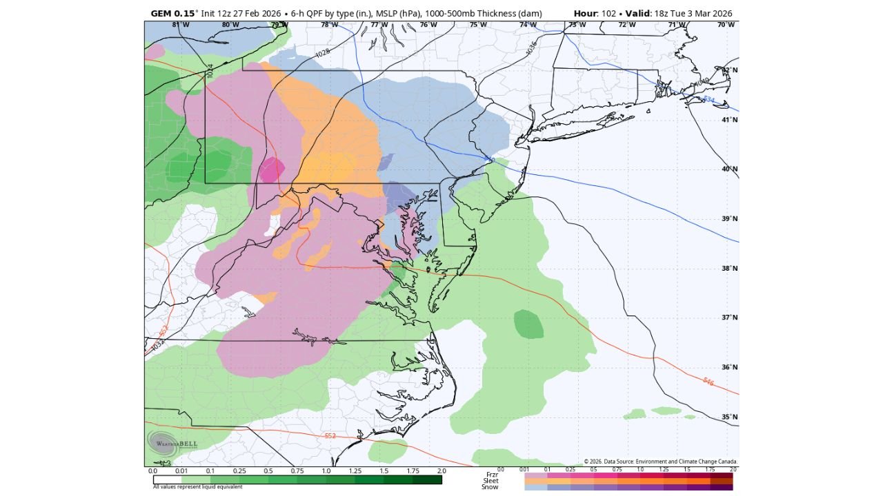
Monday Night into Tuesday: Wintry Mix Setup
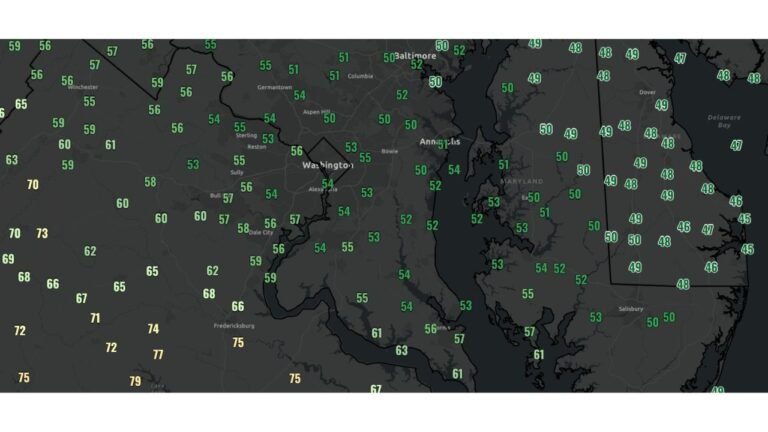
Forecast guidance valid Tuesday afternoon shows a complex precipitation shield over:
- Central Maryland
- Northern Virginia
- Southern Pennsylvania
- The Baltimore metro region
- The Washington, D.C. corridor
The thermal setup appears marginal, meaning precipitation type will depend on subtle temperature differences through the atmosphere.
Potential outcomes include:
- Light snow northwest of Baltimore
- Sleet in transition zones
- Freezing rain where surface temperatures remain below freezing
- Plain rain closer to the Chesapeake Bay and coastal areas
The most likely scenario at this point is a light, mixed event rather than a major winter storm — but even light icing can create travel concerns.
I-95 Corridor in the Crosshairs
The I-95 corridor from:
- Washington, D.C.
- Through Baltimore
- Into southern Pennsylvania
sits near the battleground between colder inland air and slightly milder coastal influence.
Small temperature shifts could move the rain/snow line by several miles.
Quick Rebound by Late Week
The good news? The cold snap doesn’t appear long-lived.
By late next week:
- Highs may rebound into the 60s
- A renewed warm pattern takes hold
- The brief winter cameo fades
This classic early-March volatility highlights just how quickly Mid-Atlantic weather can swing.
Bottom Line for Baltimore
Baltimore’s forecast over the next several days looks like a weather rollercoaster:
- 50s this weekend
- 30s Monday
- Light snow/sleet/freezing rain risk Monday night into Tuesday
- Back into the 60s by late week
Residents should monitor updates, especially if traveling Monday night or early Tuesday morning.
Stay with ChicagoMusicGuide.com for continued coverage as this sharp Mid-Atlantic temperature swing unfolds.