Southern California Faces Windy Pattern With Below-Normal Rainfall Through Mid-March While Midwest and Gulf States Trend Wetter, NOAA Outlook Shows
UNITED STATES — A persistent dry pattern is setting up across Southern California, with forecast guidance showing little to no significant storm activity through at least the middle of March, even as much of the Midwest and Gulf Coast trend wetter than normal.
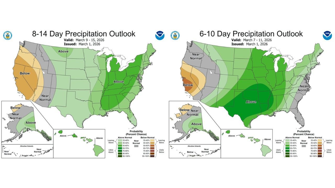
Newly issued 6–10 day and 8–14 day precipitation outlooks (valid March 7–11 and March 9–15) highlight a sharp contrast between the West Coast and the central and eastern United States.
Southern California: Windy but Dry
Forecast discussions indicate a windy setup for SoCal this upcoming week, but without meaningful storm systems attached.
The official outlook maps show:
- Below-normal precipitation favored across much of California
- The strongest dry signal centered over central and southern California
- No indication of organized storm systems reaching the region
Ensemble guidance also supports this trend, with forecasters noting no clear reasoning behind chatter suggesting significant SoCal storms in the near term.
While winds may increase due to pressure gradients, the lack of accompanying rain raises fire weather concerns, especially in areas prone to dry, gusty conditions.
Western U.S. Pattern: Limited Storm Penetration
The broader western U.S. shows a mix of near-normal to below-normal precipitation probabilities. The core dry anomaly sits over California, while portions of the interior West lean closer to normal.
This suggests:
- Storm tracks remaining displaced
- Systems either weakening before reaching California
- Or tracking farther north
The overall signal does not support widespread, soaking rainfall events in Southern California through mid-month.
Midwest and Gulf States Trending Wetter
In sharp contrast, both the 6–10 day and 8–14 day outlooks show a strong signal for above-normal precipitation across:
- Texas
- Oklahoma
- Arkansas
- Louisiana
- Mississippi
- Tennessee
- The Ohio Valley
- Portions of the Midwest, including Illinois and Indiana
The darker green shading across these regions indicates higher probabilities of above-normal rainfall, suggesting a more active storm track across the central United States.
For Illinois and surrounding Midwest states, this could mean:
- Increased rain chances
- Potential for stronger storm systems
- Wetter-than-average conditions heading deeper into March
East Coast: Mixed Signals
The eastern U.S. shows a more variable pattern, with some areas leaning near normal while others trend slightly above normal. No widespread dry anomaly is indicated there.
What This Means Going Forward
For Southern California, the key takeaway is clear:
- Wind likely increases
- Rainfall remains limited
- No significant storms expected through mid-month
Meanwhile, central U.S. states may see a more active stretch, potentially tied to developing Plains systems and Gulf moisture return.
As always with medium-range outlooks, adjustments are possible — but current guidance strongly favors a continued dry pattern for SoCal.
ChicagoMusicGuide.com will continue monitoring national weather trends, including how shifting patterns across the Plains and Midwest could evolve later in March.