Texas, Oklahoma, Kansas and Missouri Enter Five-Day Severe Weather Stretch as Tornado Risk Peaks Friday Across North Texas and the Southern Plains
UNITED STATES — A prolonged stretch of severe weather potential is taking shape across the southern Plains and into parts of the Midwest, with the Storm Prediction Center outlining five consecutive days of risk from March 4 through March 7.
The corridor of concern centers on Texas, Oklahoma, Kansas, Missouri and Arkansas, with forecasters signaling that Friday, March 6 could be the most significant tornado day of the period, particularly across North Texas, Oklahoma and Kansas.
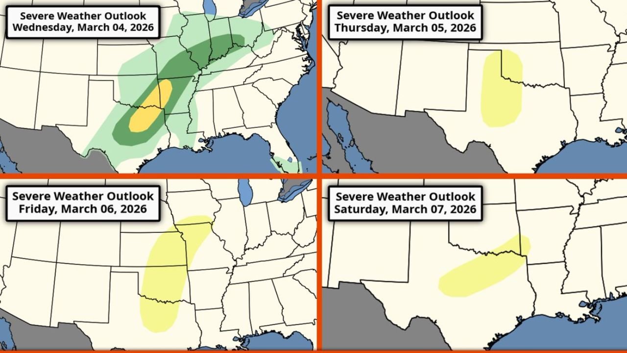
Wednesday, March 4: Southern Plains into Missouri and Arkansas
The first organized round focuses across:
- North and Central Texas
- Oklahoma
- Arkansas
- Missouri
The highlighted zone stretches northeast from Texas into the Mid-Mississippi Valley. Severe storms may produce:
- Damaging winds
- Large hail
- Isolated tornadoes
This marks the beginning of what could become a multi-day storm cycle as upper-level troughs eject eastward.
Thursday, March 5: Western Oklahoma and Kansas
On Thursday, the risk shifts slightly west and north into:
- Western Oklahoma
- Kansas
Though the risk area appears more focused and conditional, storms that do develop could still produce severe impacts. Atmospheric ingredients will determine whether storms organize or remain scattered.
Friday, March 6: Highest Tornado Potential from North Texas Through Oklahoma and Kansas
Friday currently stands out as the day to watch most closely.
Forecast projections indicate the greatest overlap of:
- Instability
- Wind shear
- Moisture return from the Gulf
The risk zone expands from:
- North Texas
- Across Oklahoma
- Into Kansas
- Possibly brushing into parts of Missouri
All hazards are possible, including:
- Significant hail
- Widespread damaging winds
- A more organized tornado threat
This is the day that could see categorical upgrades if confidence increases in storm intensity and coverage.
Saturday, March 7: Southern Plains Remain Active
The pattern remains unsettled into Saturday, with risk continuing across:
- Texas
- Oklahoma
- Parts of Arkansas
While the overall magnitude of the threat may depend on prior-day storm evolution and cloud cover, the environment still appears supportive of severe weather development.
Why This Pattern Is Concerning
Multiple days of severe weather potential can increase cumulative impacts:
- Repeated rounds over similar areas
- Saturated ground conditions
- Infrastructure strain
- Elevated tornado risk windows
The mention of a likely peak tornado setup Friday across North Texas, Oklahoma and Kansas is especially noteworthy for early March.
Bottom Line
A five-day stretch of severe weather risk from Texas through Kansas and Missouri is unfolding, with the most concerning tornado potential targeting North Texas, Oklahoma and Kansas on Friday, March 6.
Residents across the southern Plains and Mid-Mississippi Valley should closely monitor daily forecast updates as timing and storm intensity details become clearer.
ChicagoMusicGuide.com will continue tracking this developing severe weather pattern and provide updates as the week progresses.