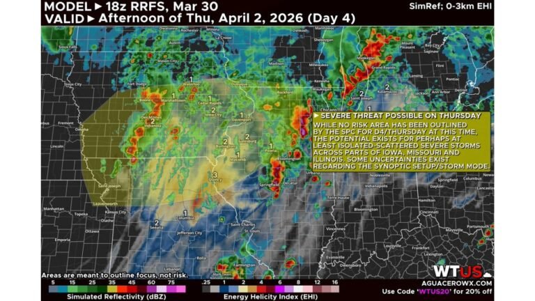
30% Severe Weather Corridor from Oklahoma to Iowa Faces Growing Model Uncertainty, Chicago Area Remains on Edge as GFS and Euro Diverge
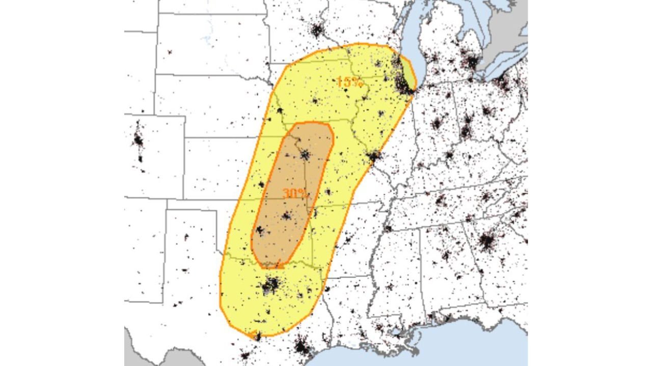
UNITED STATES — A 30% severe weather corridor stretching from central Oklahoma through eastern Kansas into western and central Iowa is under increasing scrutiny as forecast models begin to diverge on how Friday’s setup will unfold.
While a broad severe weather zone remains outlined from north Texas through Missouri and into Iowa, growing disagreement between major weather models has introduced uncertainty into how widespread and intense storms may become.
Where the 30% Corridor Is Centered
The highest severe probabilities currently focus on:
- Oklahoma City and central Oklahoma
- Eastern Kansas, including areas near Wichita
- Western and central Iowa
- Extending north toward southern Minnesota
Surrounding this core is a broader 15% severe risk that arcs northeast into parts of:
- Missouri
- Illinois
- Wisconsin
- The western Great Lakes region
For Midwest readers, this places portions of the region — including areas not far from Chicago — within the broader storm envelope.
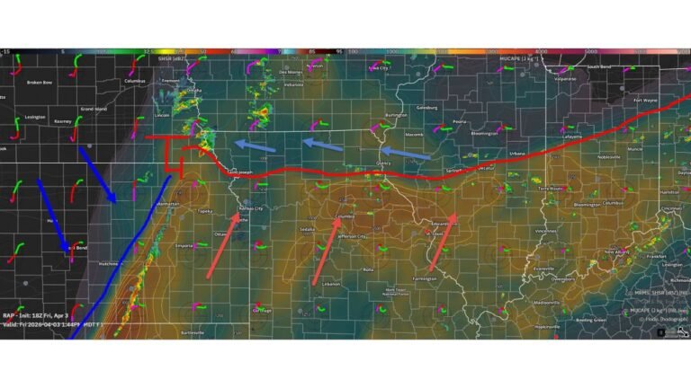
Model Disagreement Complicates Forecast
Forecast confidence has taken a hit due to diverging solutions between the GFS and European (Euro) models.
Earlier guidance showed stronger agreement. However, more recent runs depict two distinct possibilities:
- Northern Scenario: A more aggressive, crashing cold front sweeping through the Upper Midwest.
- Southern Scenario: A trough delivering more of a glancing blow across the southern Plains.
This split raises questions about storm initiation — particularly whether storms will develop cleanly and remain discrete long enough to maximize severe potential.
Initiation Concerns vs. High-End Potential
One of the main concerns is whether storms will initiate efficiently in the highest-risk zone. If forcing is too weak or poorly timed, storms may struggle to organize.
However, if the more aggressive model solution verifies — particularly the one favoring stronger dynamics — the atmosphere could support:
- Rotating supercells
- Large hail
- Damaging winds
- Tornado potential
In other words, while the 30% designation may be under debate, the environment still holds significant potential — especially across Oklahoma and Kansas.
Northern Impacts: Iowa and Toward the Midwest
Across Iowa and into southern Minnesota, the setup may depend on how far north instability can surge before frontal passage.
If the northern solution verifies, storms could extend into:
- Des Moines
- Cedar Rapids
- Possibly toward the Upper Midwest
Farther east, including into Illinois, the risk may hinge on how much instability survives eastward.
Why Chicago Should Still Pay Attention
Even though the highest probabilities remain southwest of Illinois, the broader severe zone includes portions of the Midwest.
Storms developing in the Plains could track northeast, especially if the stronger model solution proves correct. While Chicago is not currently in the 30% core, shifts in the track or timing could expand impacts.
Bottom Line
A 30% severe weather corridor from Oklahoma through Kansas into Iowa remains in place for Friday, but model disagreement between the GFS and Euro introduces uncertainty regarding storm coverage and intensity.
If the more dynamic scenario verifies, severe storms — including supercells — could materialize with notable impacts. If not, storm coverage may be more scattered and less organized.
ChicagoMusicGuide.com will continue monitoring forecast trends as confidence increases and model agreement improves heading into Friday.