Texas, Oklahoma and Kansas Brace for Dangerous Severe Storm Outbreak With Tornadoes, 75+ MPH Winds and Giant Hail Threat
CENTRAL UNITED STATES — A dangerous multi-day severe weather outbreak is unfolding across the central United States, with forecasters warning that tornadoes, destructive winds, and very large hail are all possible from Texas through Oklahoma and Kansas as the threat intensifies into Friday.
Meteorologists say the storm system could affect millions of people across the Plains and Midwest, with the highest initial threat focused across the Texas Panhandle, western Oklahoma, and parts of Kansas.
The severe weather pattern is expected to expand eastward and strengthen as the system evolves, raising concerns for a broader tornado risk across additional states.
Thursday: Texas Panhandle and Western Oklahoma Under Highest Initial Risk
For Thursday, the severe weather focus centers on areas near Amarillo, Childress, Elk City, and Lawton, where atmospheric conditions may support rotating thunderstorms capable of producing tornadoes.
Forecast guidance places a TOR:CON 4 tornado risk near Amarillo and Childress, with a TOR:CON 3 risk extending toward Oklahoma City and Lawton.
TOR:CON values are used to estimate the likelihood of tornado activity within a region during severe weather setups.
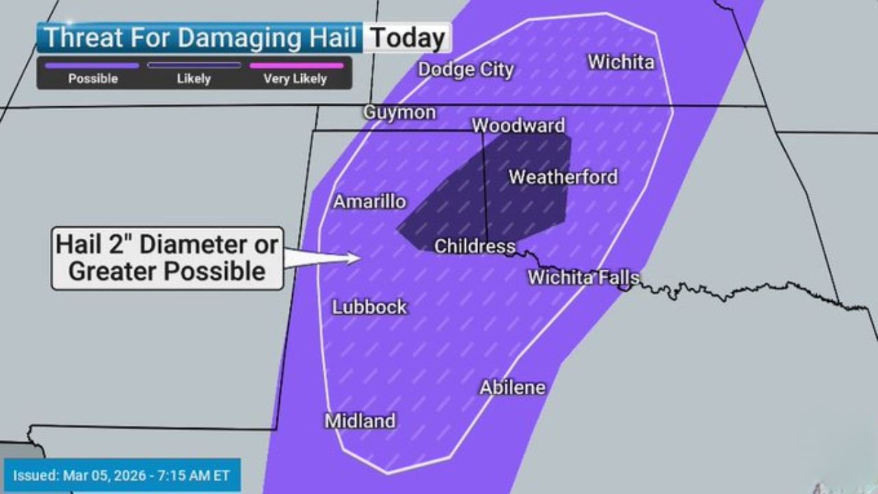
In addition to tornado potential, storms could also produce damaging wind gusts exceeding 75 mph and very large hail measuring two inches in diameter or larger.
Cities including Lubbock, Woodward, Wichita Falls, and Abilene fall within the zone where these hazards could develop.
Large Hail and Destructive Winds Possible
Storms developing across the region may become powerful supercells capable of generating significant hail and intense wind gusts.
Weather models show the potential for hailstones larger than two inches, particularly across areas stretching from Amarillo through Childress and toward western Oklahoma.
At the same time, a corridor of strong winds could push northward through Woodward, Enid, Wichita, and Emporia, where gusts exceeding 75 mph may occur in stronger storm clusters.
Such wind speeds can cause tree damage, power outages, and hazardous travel conditions.
Friday: Tornado Risk Expands and Intensifies
By Friday, the severe weather threat is expected to shift farther east while becoming more intense.
Forecast projections show the tornado risk increasing to TOR:CON 5 across a broad corridor that includes Oklahoma City, Tulsa, Wichita, and Kansas City.
Additional risk zones extend southward toward Dallas and Texarkana, while the northern portion of the storm system could impact Springfield, St. Louis, Omaha, and Cedar Rapids.
This expanding corridor suggests a larger area of the central United States could face severe storms capable of producing tornadoes.
Widespread Severe Weather Expected
Beyond tornadoes, the storm system is also expected to produce widespread damaging winds and large hail across multiple states.
Forecasters warn the severe weather threat could stretch from North Texas through Oklahoma and Kansas and northward toward Iowa as the storm complex organizes and moves east.
With multiple severe weather hazards possible, meteorologists emphasize that residents across the region should remain weather aware and ensure alerts are enabled on their phones or weather radios.
Residents Urged to Prepare for Rapid Weather Changes
Severe weather outbreaks in the Plains can evolve quickly, particularly when strong wind shear combines with warm, unstable air.
Forecasters stress that conditions may change rapidly once storms begin forming, meaning warnings could be issued with little lead time.
People living across the risk area are encouraged to review their severe weather safety plans and identify safe shelter locations ahead of time.
For continuing coverage of major weather threats across the United States, follow updates from ChicagoMusicGuide.com.