Oklahoma and North Texas Storm Threat Evolves Overnight as 700 mb Shortwave Sparks New Thunderstorm Development
OKLAHOMA CITY, OKLAHOMA — Meteorologists monitoring weather patterns across Oklahoma, North Texas, and parts of Arkansas say the storm environment is evolving as a 700 mb shortwave disturbance moves through the region. While earlier expectations suggested storms might develop along a dryline, new analysis indicates the atmosphere is behaving differently, with mid-level forcing now playing the dominant role in storm development.
Satellite imagery and mesoscale weather analysis show cloud development increasing across central Oklahoma extending south toward the Dallas–Fort Worth region, while drier and more stable air persists farther west. Forecasters note that surface heating has weakened with time, which has reduced the chance of storms forming directly along the dryline. Instead, the focus has shifted to the advancing upper-level disturbance that could still spark storms overnight.
Meteorologists Identify 700 mb Shortwave as Primary Trigger
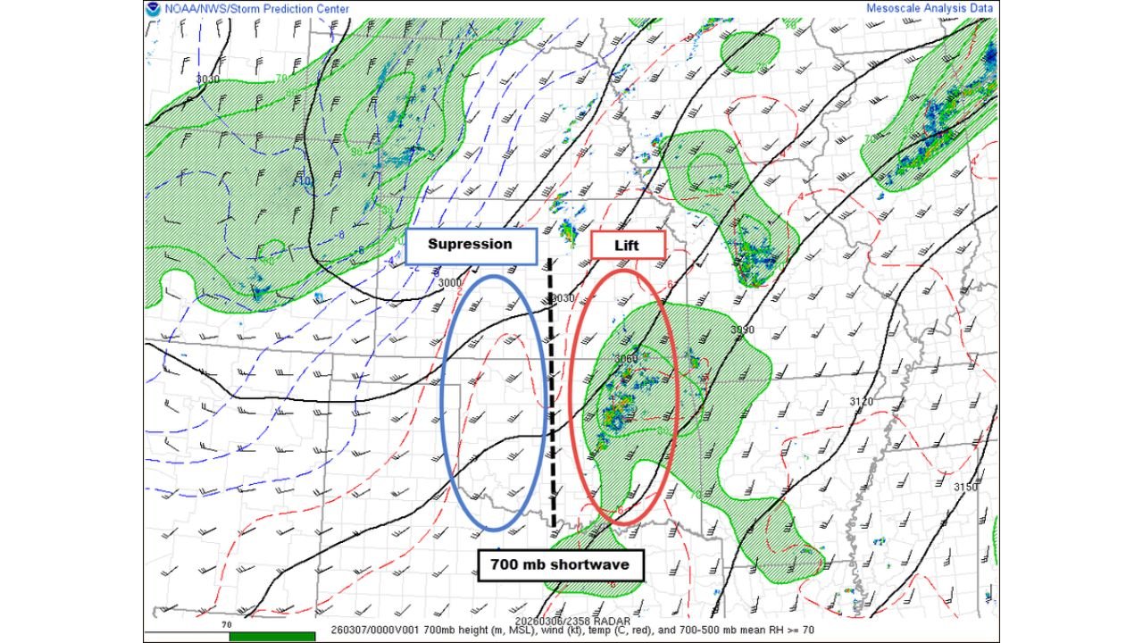
Weather analysts studying mesoscale analysis data and mid-level wind fields say the main driver for storm initiation appears to be a shortwave trough around the 700 millibar level, located over central Oklahoma. This atmospheric feature is creating lift across a more saturated air mass east of the dryline, helping storms form despite less favorable surface conditions.
The analysis maps highlight two distinct atmospheric zones across the Southern Plains. To the west of the shortwave axis, forecasters are seeing suppression and drier air, which limits thunderstorm development. Meanwhile, east of the axis, the atmosphere contains higher moisture and instability, allowing storms to organize as the disturbance moves through.
Meteorologists say this contrast explains why storms are forming in clusters east of central Oklahoma, even though the stronger instability initially expected farther west has not fully materialized.
Satellite Imagery Shows Cloud Bands Stretching Across Oklahoma and Texas
Recent satellite imagery covering Oklahoma, Kansas, Arkansas, and Texas shows a band of clouds stretching from north-central Oklahoma southward into North Texas near Dallas. These cloud structures often signal upper-level disturbances interacting with moisture-rich air, a setup that can support thunderstorm growth.
The imagery also reveals clearer skies across western Oklahoma and parts of the Texas Panhandle, confirming the presence of the drier, more suppressed environment. This pattern matches the meteorological analysis indicating that storm development will favor areas east of the shortwave axis, rather than along the dryline itself.
Cities including Oklahoma City, Tulsa, and parts of the Dallas–Fort Worth metroplex may remain near the edge of the developing storm zone depending on how the disturbance shifts during the evening hours.
Cold Front Expected to Sustain Storm Activity Overnight
Forecasters say the situation will continue to evolve overnight as a cold front pushes southward through Oklahoma and North Texas. Even if storms remain somewhat elevated above the surface layer, meteorologists caution that large instability and strong wind shear remain present in the atmosphere.
This combination could allow storms to strengthen despite limited surface heating. Elevated thunderstorms along the advancing front may still produce heavy rainfall, strong wind gusts, and localized lightning activity as the night progresses.
Weather experts emphasize that storm development may remain scattered and somewhat unpredictable, depending on how the shortwave interacts with the incoming frontal boundary. However, they stress that the overall atmospheric setup suggests the night is far from over for storm activity across the region.
Residents across Oklahoma, North Texas, and nearby parts of Arkansas and Kansas are encouraged to monitor local forecasts as the system evolves.
As meteorologists continue tracking this dynamic Southern Plains weather setup, further updates on overnight storm development and regional impacts will be provided. For continuing coverage of major weather patterns, storm risks, and regional forecasts across the United States, visit ChicagoMusicGuide.com.