Midwest and Northeast Brace for Spring Tease as Temperatures Surge Toward 80 Before Sharp Pattern Flip Brings Back Chilly Air
UNITED STATES — A dramatic weather shift is expected to unfold across the Midwest and Northeast United States, where meteorologists say a burst of springlike warmth could send temperatures 20 to 30 degrees above normal by midweek before another pattern change sends colder air back into the region.
Forecast guidance indicates that once lingering cool air clears out of the eastern half of the country, several days of genuinely warm conditions may take hold across large parts of the Great Lakes, Ohio Valley, and Northeast.
In some locations, forecasters say temperatures could approach or even briefly reach 80 degrees, an unusually warm reading for mid-March.
Warm Air Set to Spread Across the Eastern United States
Meteorologists explain that the upcoming warm spell will develop once winds shift away from the ocean and begin drawing milder continental air northward across the eastern U.S.
Without persistent ocean influence, temperatures can climb much more efficiently inland. That setup is expected to allow warm air to surge through areas including Illinois, Michigan, Ohio, Pennsylvania, New York, and surrounding states.
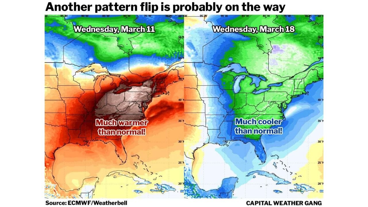
Weather model projections show much of the eastern United States experiencing well-above-average temperatures, with some regions running 20 to 30 degrees warmer than typical for this time of year.
For mid-March, such departures from normal could translate into widespread high temperatures in the 70s, with a few locations possibly pushing toward 80 degrees before the warm pattern ends.
Cold Front Expected to End the Warm Pattern
While the warm weather may feel like an early preview of spring, meteorologists say it will likely be short-lived. A cold front expected around Thursday is projected to sweep across the eastern U.S., gradually bringing temperatures back down.
Even after the initial front moves through, the following weekend could remain relatively mild for several days, depending on how quickly colder air pushes south.
However, long-range guidance suggests the atmosphere may soon transition into a different large-scale pattern.
Jet Stream Shift May Bring Colder Conditions Back
Weather models indicate that after the brief warm stretch, the jet stream may dip southward across the Northeast United States. This shift would allow colder air to spread across parts of the region roughly a week after the peak of the warm spell.
The developing pattern may be linked to a large high-pressure system building over the western United States, which can force the jet stream to bend south across the eastern half of the country.
If that pattern materializes, temperatures across parts of the Great Lakes, Mid-Atlantic, and Northeast could drop to 10 to 15 degrees below average.
In mid-March, those colder readings could mean daytime highs in the 30s to mid-40s and nighttime lows dipping into the 20s.
Rapid Pattern Swings Highlight Unstable Early-Spring Weather
Meteorologists say the forecast reflects a classic early-spring pattern flip, when warm surges and cold air outbreaks can alternate quickly as the atmosphere transitions from winter toward spring.
While details of the exact timing and strength of the upcoming cool-down may still change, the overall signal suggests that the current warm pattern will not last indefinitely.
For now, forecasters expect much of the Midwest and Northeast to experience several days of notably warm weather before the next wave of colder air potentially arrives later in March.
Stay with ChicagoMusicGuide.com for continuing updates on evolving U.S. weather patterns, including severe storms, temperature swings, and major forecast changes.