Texas Oklahoma Arkansas Missouri and Illinois Could See Major Severe Weather Outbreak Tuesday With Tornadoes Large Hail and Damaging Winds
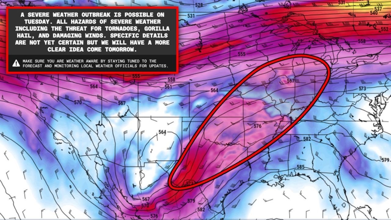
DALLAS, TEXAS — Forecast guidance is signaling the potential for a large severe weather outbreak across the central United States on Tuesday, March 10, as a powerful storm system moves across the Plains and Midwest. Current model projections indicate that tornadoes, large hail, and damaging winds may develop from Texas and Oklahoma northeastward through Arkansas, Missouri, and into Illinois.
A broad warm sector is expected to expand across the region ahead of an approaching upper-level trough, creating an environment capable of supporting intense thunderstorms. Meteorological models suggest that several areas within this corridor could become focused zones for severe storm development during the afternoon and evening hours.
Warm Sector Setup Could Fuel Widespread Severe Storm Development
Forecast data shows a large warm sector developing across the southern Plains and Midwest, where warm, moisture-rich air from the Gulf of Mexico will interact with strong winds in the upper atmosphere.
This combination often creates the ingredients needed for organized severe thunderstorms capable of producing tornadoes and destructive hail. Model projections suggest that multiple storm clusters or supercells could develop within this warm sector, especially during the afternoon as atmospheric instability increases.
The corridor of concern stretches from north Texas and central Oklahoma through Arkansas and Missouri into parts of Illinois, where storms could intensify as the weather system pushes northeast.
Northern Illinois Could See Increased Tornado Potential
Forecast guidance also highlights a warm frontal zone across northern Illinois, which could enhance the tornado threat during the afternoon hours.
Warm fronts often act as a boundary where storms can gain additional rotation due to stronger low-level wind shear, increasing the possibility that thunderstorms may become rotating supercells.
If storms interact with this boundary, areas across northern Illinois including Chicago, Rockford, and surrounding communities could experience an elevated tornado risk compared with surrounding regions.
However, the exact placement of this boundary remains uncertain and may shift as new forecast data becomes available.
Dry Line Across Texas and Oklahoma May Trigger Early Storms
At the same time, forecast models indicate that a dry line may develop across western Texas and western Oklahoma, another key feature known for initiating severe thunderstorms.
Dry lines form where dry desert air collides with warm humid air, often producing explosive thunderstorm development during the afternoon.
Storms that develop along this boundary could rapidly intensify into supercells capable of producing tornadoes, very large hail, and damaging wind gusts before moving northeast toward the Midwest.
Forecast Details Still Evolving Ahead of Tuesday System
Although early signals suggest a potentially significant severe weather event, the exact locations of the strongest storms remain uncertain.
Weather models continue to refine the position of the warm front, dry line, and strongest wind fields, which will determine where the most dangerous storms develop.
Residents across Texas, Oklahoma, Arkansas, Missouri, and Illinois should continue monitoring updated forecasts as the system approaches.
As the severe weather setup becomes clearer over the coming days, ChicagoMusicGuide.com will continue providing updates on storm risks, tornado potential, and forecast changes affecting communities across the central United States.