Illinois and Missouri Face Conditional Tornado Threat Tuesday as Warm Front and Intense Storm Energy Build Across the Midwest
ILLINOIS — A developing weather system across the Midwest, particularly Illinois and Missouri, is drawing attention from forecasters as atmospheric conditions Tuesday could support strong thunderstorms, large hail, and a conditional tornado threat. Forecast guidance suggests storms may develop along a warm front stretching across parts of Illinois and Missouri, though meteorologists warn that several factors could either limit storm development or allow isolated severe storms to intensify quickly.
While the environment contains ingredients typically favorable for severe weather, models indicate that storm initiation may be uncertain, meaning the severity of Tuesday’s outbreak could depend heavily on where storms actually form.
Conditional Tornado Threat Emerges Across Illinois and Missouri
Forecast guidance indicates that Illinois and Missouri will sit near a warm frontal boundary, where a sharp contrast between cooler northern air and much warmer southern air may help trigger thunderstorms. This setup can sometimes create environments supportive of rotating storms capable of producing tornadoes, especially near the boundary where wind shear is strongest.
However, meteorologists emphasize that the tornado threat remains conditional. Forecast discussions note that storms must become surface-based along the warm front in order for tornado potential to increase. If storms remain elevated or struggle to organize, the tornado threat could remain limited.
Still, the atmospheric pattern shows strong wind fields and sufficient instability, meaning that if storms do form in the right location, isolated intense storms could develop quickly across parts of Illinois and Missouri.
Temperature and Mixing Could Limit Storm Development
One of the most significant uncertainties involves surface heating and atmospheric mixing across the region. Forecast models suggest temperatures could climb into the low to mid-80s across parts of Missouri and southern Illinois, while dew points may remain only in the low 60s.
That combination creates a large temperature-to-dewpoint spread, which often causes storms to become high-based or struggle to initiate altogether. When the air near the surface becomes too dry, storms may have difficulty forming strong updrafts needed for severe weather.
This factor could reduce the number of storms that form Tuesday, meaning that while the environment supports severe weather, actual storm coverage may remain scattered.
If storms fail to develop along the warm front, the severe weather risk would drop significantly across Illinois, Missouri, and surrounding Midwest states.
Large Hail Could Become the Primary Threat
If thunderstorms do develop along the northern portion of the boundary, the cooler air near the surface combined with strong winds aloft may favor storms capable of producing very large hail.
Forecast models show strong mid-level winds and favorable storm rotation parameters, particularly across sections of central and northern Illinois as well as eastern Missouri. In these areas, storms could grow tall and organized enough to produce severe hail events, potentially larger than golf balls.
Large hail often occurs in environments where storms remain slightly elevated but still maintain strong updrafts, which is a scenario that appears possible Tuesday evening.
This means residents across Illinois and Missouri should monitor weather updates even if tornado warnings do not materialize, as damaging hail and intense thunderstorms remain possible hazards.
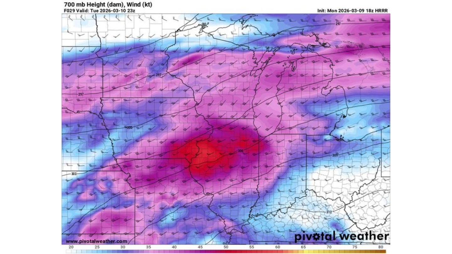
Strong Wind Fields Could Support Severe Storm Organization
Another key feature in Tuesday’s setup involves strong winds throughout the atmosphere, particularly in the mid-levels around 700 millibars. Forecast maps show a broad corridor of strong wind energy moving through Missouri into Illinois, helping create a favorable environment for organized thunderstorms.
Wind shear — the change in wind speed and direction with height — is expected to be strong enough to support rotating thunderstorms or supercells if storms become surface-based.
This wind structure is one reason forecasters remain cautious about the forecast despite uncertainty around storm initiation. Even a small number of storms forming in the right location could rapidly become severe.
Such setups often produce isolated but intense storms, rather than widespread severe weather outbreaks.
Midwest Residents Urged to Monitor Changing Forecast
Because the severe weather threat is highly dependent on storm development along the warm front, meteorologists say the forecast could shift quickly throughout Tuesday afternoon and evening.
If storms develop farther south where instability is stronger, the risk of severe thunderstorms and isolated tornadoes across Missouri and Illinois could increase. If storms remain limited or elevated, the primary threat may shift toward hail and scattered thunderstorms instead.
Residents across Illinois, Missouri, and neighboring Midwest states should remain weather aware as the situation evolves. Forecast models and radar trends Tuesday afternoon will likely determine how significant the severe weather threat becomes.
As conditions continue to develop across the Midwest, meteorologists will be closely monitoring the atmosphere for signs that storms are beginning to organize along the boundary.
For continued updates on severe weather, Midwest storms, and regional forecast developments, visit ChicagoMusicGuide.com for the latest weather coverage and analysis.