SPC Issues Mesoscale Discussion for Central Illinois as Tornado Watch 32 Continues with Threat of 100–130 mph Tornadoes and Growing Damaging Wind Risk
CENTRAL ILLINOIS — The Storm Prediction Center has issued a Mesoscale Discussion for parts of central Illinois as severe storms continue to move east out of Missouri and Iowa into the heart of the state. The discussion highlights ongoing concerns within Tornado Watch 32, where tornadoes, large hail, and an increasing damaging wind threat are expected to persist through the evening and overnight hours.
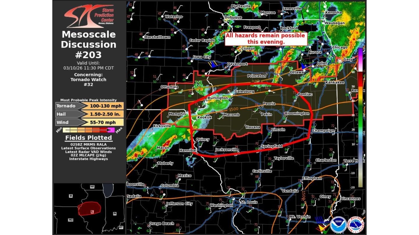
Storm clusters are already active from far eastern Missouri and southeast Iowa into western and central Illinois, with multiple storm modes currently observed across the watch area.
Storms Ongoing from Iowa and Missouri into Illinois
Radar imagery shows organized clusters extending from near Ottumwa, Iowa, through Burlington and Keokuk, and into western Illinois communities including Macomb, Quincy, and Galesburg. Additional strong cells are moving toward Peoria, Pekin, Havana, Lincoln, Bloomington, and Pontiac.
Some storms remain more discrete on the western edge of the watch, particularly near the Illinois–Missouri border. These isolated supercells pose the greatest tornado potential before storms gradually merge.
As activity continues eastward, storms will enter an environment characterized by:
- Strong wind shear
- Sufficient instability
- Increasing low-level wind fields
These ingredients support continued organization and the ability to produce multiple severe hazards.
All Hazards Remain Possible
The Mesoscale Discussion emphasizes that all hazards remain possible this evening, including:
- Tornadoes
- Hail ranging from 1.5 to 2.5 inches in diameter
- Damaging wind gusts between 55 and 70 mph
The most probable peak tornado intensity within the watch area is estimated between 100 and 130 mph, placing stronger tornadoes in the EF1 to low-end EF2 range if they develop.
Transition Toward Linear Clusters Overnight
Forecasters expect storm evolution over time. While isolated supercells are still present, storms are likely to grow and merge into one or more linear clusters as they progress across central Illinois.
If that transition occurs, the primary hazard will gradually shift toward more widespread damaging wind, though a few tornadoes will remain possible along embedded circulations within the line.
This scenario suggests that even after the initial supercell phase diminishes, the severe threat will not immediately end.
Communities in the Core Impact Zone
The highlighted area of concern spans much of central Illinois, including:
- Galesburg
- Macomb
- Peoria
- Pekin
- Havana
- Lincoln
- Bloomington
- Pontiac
- Areas near Princeton and Ottawa
Storms will continue tracking east-northeast, with additional impacts possible farther east later tonight.
Overnight Vigilance Required
Because severe storms are expected to continue through the overnight period, residents across central Illinois should remain alert even after dark. Nocturnal severe weather increases risk due to reduced visibility and sleeping populations.
Residents are encouraged to:
- Keep weather alerts enabled
- Ensure multiple ways to receive warnings overnight
- Identify shelter locations in advance
With Tornado Watch 32 still active and storm organization ongoing, central Illinois remains in a dynamic and potentially dangerous severe weather environment.
ChicagoMusicGuide.com will continue monitoring storm progression and provide updates as conditions evolve across Illinois overnight.