Historic Kona Low Targets Honolulu and Oahu with 13 Inches of Rain, 20–30 Inches in Higher Terrain, and Blizzard Conditions on Hawaii’s Peaks
HONOLULU, HAWAII — A powerful Kona Low is set to slam the Hawaiian Islands this week, bringing a dangerous combination of significant flooding, severe thunderstorms, damaging winds, and even blizzard conditions on the state’s highest peaks.
According to the latest forecast data, Honolulu could see 13 inches of rain between Tuesday and Saturday, an astonishing amount that represents nearly 80% of the city’s average annual rainfall compressed into just five days.
Potentially Historic Rainfall for Honolulu
Forecasters note that outside of the extraordinary March 1958 storm — which holds all five of the top rainfall records — this event could mark the wettest five-day stretch in Honolulu since records began in 1940.
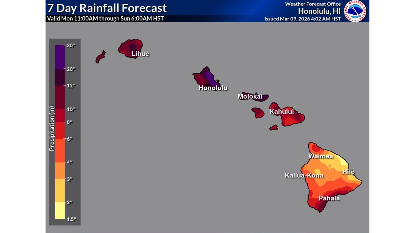
The 7-day rainfall forecast highlights:
- Oahu (including Honolulu): 10–15+ inches, with locally higher totals
- Higher terrain on Oahu: 20–30 inches possible through Sunday
- Kauai (including Lihue): Widespread heavy rainfall as impacts begin early
- Maui County (Kahului, Molokai): Significant rainfall totals
- Big Island (Hilo, Waimea, Pahala, Kailua-Kona): Heavy rain, especially windward areas
The most extreme totals are expected in mountainous terrain, where upslope flow will dramatically enhance rainfall.
Flooding Concerns Growing Across the Islands
With rainfall rates expected to be intense at times, flash flooding and urban flooding are major concerns, particularly in:
- Honolulu metro areas
- Windward slopes of Oahu
- Kauai as impacts begin tonight
- Windward sections of the Big Island near Hilo
Low-lying roads, streams, and flood-prone neighborhoods could quickly become inundated if repeated heavy bands train over the same areas.
Severe Thunderstorms and Damaging Winds
Beyond flooding, the Kona Low is expected to generate strong to severe thunderstorms, particularly where instability increases around the circulation.
Damaging wind gusts could accompany heavier squalls, especially in exposed coastal and elevated locations.
The circulation pattern typical of Kona Lows can also create prolonged periods of heavy rainfall as moisture wraps around the system and repeatedly impacts the same islands.
Blizzard Conditions on Hawaii’s Highest Peaks
In stark contrast to the tropical downpours below, the highest elevations — including the summits of Mauna Kea and Mauna Loa — could experience blizzard conditions, with snow and strong winds creating hazardous conditions at altitude.
This sharp elevation contrast underscores the strength and depth of the incoming system.
Impacts Begin on Kauai
Impacts are already expected to begin on Kauai, where rain bands will move in first before spreading eastward across Oahu, Maui County, and eventually the Big Island.
The prolonged nature of the event — lasting through at least Saturday, with higher terrain impacts continuing into Sunday — raises concerns about cumulative rainfall totals reaching extreme thresholds.
A Multi-Day High-Impact Event
Unlike short-lived tropical downpours, this Kona Low represents a multi-day high-impact weather event, with:
- Repeated rounds of heavy rainfall
- Increasing flood risk
- Severe thunderstorm potential
- Damaging winds
- Snow and blizzard conditions at high elevations
Residents across the Hawaiian Islands, particularly on Oahu and Kauai, should closely monitor updates and prepare for rapidly changing conditions.
ChicagoMusicGuide.com will continue tracking this potentially historic Kona Low as it unfolds across Hawaii this week.