Tornado Watch Issued for Central and Southern Oklahoma as Discrete Supercells Rapidly Intensify from Oklahoma City to Lawton and Ponca City
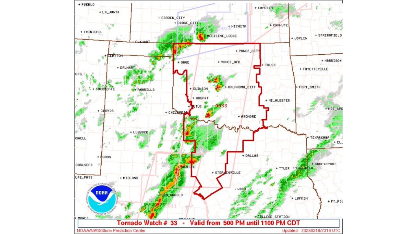
CENTRAL & SOUTHERN OKLAHOMA — A rapidly evolving severe weather situation is unfolding this afternoon across central and southern Oklahoma, where discrete supercells have developed and intensified, prompting the issuance of Tornado Watch #33, valid from 5:00 PM until 11:00 PM CDT.
Radar imagery shows multiple rotating storms scattered from near Clinton and Hobart eastward toward Oklahoma City, with additional development extending south toward Lawton and north toward areas near Ponca City.
Discrete Supercells Developing
Unlike a solid line of storms, today’s setup features individual supercells, which are often more capable of producing tornadoes due to their isolated structure.
Satellite imagery reveals towering updrafts punching high into the atmosphere across western and central Oklahoma. These discrete cells are taking advantage of strong instability in place this afternoon.
While forecasters note that low-level wind shear is currently somewhat limited, atmospheric conditions are expected to improve over the next couple of hours. As that happens, storms could become more efficient at producing:
- Tornadoes
- Large hail
- Damaging wind gusts
Tornado Watch #33 Covers Broad Area
The Tornado Watch includes much of central and southern Oklahoma, encompassing communities such as:
- Oklahoma City
- Clinton
- Hobart
- Chickasha
- Areas stretching north toward Ponca City
- Southward toward the Red River region
The watch also borders parts of north Texas, where storms are beginning to organize into clusters.
Environment Expected to Strengthen
Forecasters emphasize that although tornado potential may be somewhat limited at the moment due to weaker low-level shear, the environment is expected to become more favorable as the evening progresses.
If wind fields strengthen and storms maintain their discrete character, the tornado risk could increase before storms begin merging into clusters.
Additionally, high instability and strong mid-level wind speeds support:
- Large hail potential
- Localized damaging winds
- Continued storm intensification through early evening
What Happens Next?
As the evening unfolds, storms may either:
- Remain semi-discrete and capable of producing tornadoes
- Begin merging into clusters, increasing the wind threat
Residents across central and southern Oklahoma should remain weather aware, especially in and around Oklahoma City and surrounding counties.
With Tornado Watch #33 in effect until 11 PM CDT, conditions remain favorable for severe weather development over the next several hours.
ChicagoMusicGuide.com will continue monitoring this rapidly changing severe weather situation as supercells track across Oklahoma this evening.