Texas, Louisiana, Mississippi, Alabama, Tennessee, Kentucky, Illinois, and Indiana Face Sunday Severe Storm Threat With Damaging Winds and Possible Tornadoes
MEMPHIS, TENNESSEE — Severe thunderstorms — and perhaps a few tornadoes — are expected to develop Sunday across parts of the Mid-South, with the threat possibly extending north into the Midwest, including portions of Illinois and Indiana.
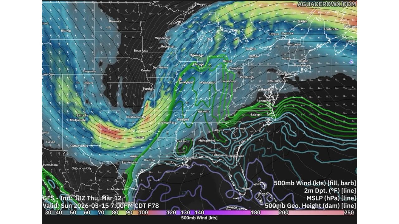
Forecast guidance shows a strong upper-level system sweeping eastward, with dynamic support increasing along a cold front from Texas through Louisiana, Mississippi, Alabama, Tennessee, and Kentucky, and potentially into southern Illinois and Indiana by Sunday evening.
Strong Upper-Level Dynamics Driving the Setup
Model data highlights a powerful 500mb jet streak rounding the base of a deep trough over the central United States. Wind speeds aloft appear robust from Dallas and Little Rock northeastward toward Memphis, Nashville, Louisville, and Indianapolis.
This upper-level energy will overspread a developing line of storms along the advancing cold front. Even if low-level moisture is somewhat limited due to a recent moisture sweep, forecast soundings suggest there may still be enough instability to support organized convection.
Line of Storms Likely Along the Cold Front
Guidance indicates a likely scenario involving a squall line forming from eastern Texas through Arkansas, Louisiana, and into Mississippi and Tennessee.
Cities that may see strong storms include:
- Dallas
- Shreveport
- Little Rock
- Jackson (MS)
- Memphis
- Nashville
- Louisville
- Portions of southern Illinois and Indiana
The primary threat appears to be damaging straight-line winds, especially if storms consolidate into a fast-moving line. However, embedded circulations within that line could produce isolated tornadoes, particularly in areas where low-level wind shear strengthens during the evening hours.
Midwest Extension Possible
As the system lifts northeast, storms may push into parts of:
- Kentucky
- Southern Indiana
- Southern Illinois
- Possibly into western Ohio
While instability may weaken with northward extent, strong dynamic forcing could compensate enough to maintain at least a marginal severe risk.
Moisture Question Remains a Key Factor
Forecasters note that recent weather patterns may limit the depth of Gulf moisture returning ahead of the front. This introduces some uncertainty regarding how widespread the severe threat becomes.
If moisture return is stronger than currently projected, the risk of more robust severe storms — including a few stronger tornadoes — would increase. If moisture remains modest, damaging winds would remain the dominant concern.
Timing: Sunday Afternoon Through Night
Storm development is expected to begin Sunday afternoon in Texas and Arkansas, spreading eastward through the Mid-South during the evening, and potentially reaching parts of the Ohio Valley overnight.
Residents across the region should monitor updated forecasts and ensure multiple ways to receive warnings.
For continued updates on severe weather threats and major storm systems across the United States, visit ChicagoMusicGuide.com.