Wisconsin Could See Rare Overnight Mini-Supercells With Rain, Snow, Sleet and Small Hail as Unusual Cold-Core Storm Spins Near Duluth and Minneapolis
EAU CLAIRE, WISCONSIN — An unusual and meteorologically fascinating setup could unfold Thursday night into very early Friday across parts of Wisconsin, as a powerful cold-core low pressure system swings through the Upper Midwest.
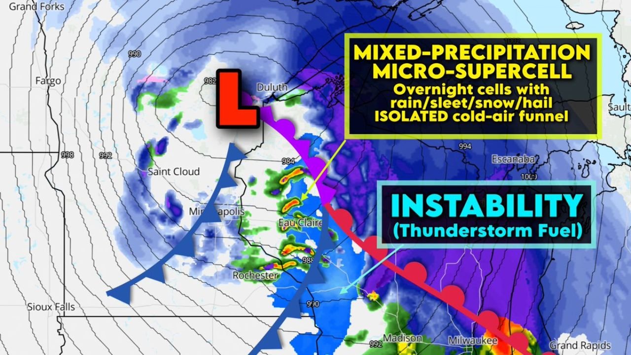
Forecasters are monitoring the potential for elevated mini-supercells capable of producing rain, snow, sleet, or small hail, and possibly even a brief, harmless cold-air funnel cloud.
While this activity would likely occur overnight — limiting visibility for most residents — the atmospheric ingredients in place are anything but ordinary.
Cold-Core Low Spinning Near Duluth and Minneapolis
A deep low pressure center is projected to track near Duluth, Minnesota, with wraparound moisture extending into:
- Eau Claire
- Rochester, Minnesota
- Madison
- Portions of western and central Wisconsin
After the initial cold front passes, the region enters what meteorologists call the “dry slot” of the storm system — an area where colder air aloft overspreads slightly less-cold air at mid-levels.
This creates a pocket of elevated instability roughly a mile above the ground.
Elevated Instability Sparks Thunderstorm Potential
Despite surface temperatures likely sitting in the 30s overnight, the air aloft becomes exceptionally cold. That contrast allows rising motion to generate instability — essentially thunderstorm fuel — above the surface layer.
With:
- Leftover moisture
- Strong spin (vorticity) near the low center
- Steep lapse rates aloft
a few low-topped, rotating cells could develop.
These would not be traditional warm-season supercells, but rather compact, cold-season “mini-supercells.”
Mixed Precipitation Possible
Because surface temperatures remain near freezing in many areas, any stronger cell could produce a mix of:
- Rain
- Wet snow
- Sleet
- Small hail (graupel possible)
Communities from Eau Claire to Madison and possibly toward Milwaukee may see brief bursts of convective precipitation embedded within the broader system.
Cold-Air Funnel Potential
One of the more unusual aspects of this setup is the possibility of a cold-air funnel cloud.
Cold-air funnels are typically weak and rarely reach the ground. They form in environments with strong spin aloft but limited surface-based instability. If any funnels develop, they would most likely be short-lived and non-damaging.
Because this activity is expected overnight, visibility would be limited, meaning most funnel clouds — if they form — may go unseen.
A Meteorological Curiosity
Cold-season elevated convection with rotating structures is rare but not unprecedented in the Upper Midwest. The combination of:
- A deep cold-core low
- Steep lapse rates
- Wraparound moisture
- Marginal but sufficient instability
creates a setup that is more commonly discussed in meteorology classrooms than observed in real time.
While impacts are expected to remain minor, the atmospheric mechanics behind this event make it one of the more fascinating features of the current storm cycle affecting Minnesota and Wisconsin.
For continuing updates on unusual weather events across the Upper Midwest and Great Lakes, stay with ChicagoMusicGuide.com.