Rare Day 4 Enhanced Risk Issued for Washington DC and Northern Virginia as Powerful Jet and Cold Front Signal Damaging Wind and Tornado Potential Monday
WASHINGTON, DC — The Storm Prediction Center has taken the unusual step of issuing a Day 4 Enhanced Risk for portions of the Mid-Atlantic, placing Washington, DC, northern Virginia, and nearby Maryland communities in a heightened severe weather outlook for Monday.
Enhanced Risk areas at four days out are uncommon, underscoring forecasters’ growing concern about an increasingly dynamic setup expected to unfold as a powerful mid-level jet streak overspreads the region while a strong cold front sweeps east.
Enhanced Risk Focused on DC, Northern Virginia and Maryland
Current outlook maps show the Enhanced Risk centered near:
- Washington, DC
- Northern Virginia
- Central and eastern Maryland
- Areas extending north toward southern Pennsylvania
Surrounding this zone is a broader Slight Risk stretching southward through eastern Virginia and into the Carolinas, including Norfolk, Raleigh, and Charleston.
The alignment of strong wind energy aloft with a sharpening frontal boundary has prompted early concern that this system could organize quickly as it moves through the I-95 corridor.
Damaging Winds the Primary Threat
Forecasters indicate the main hazard appears to be damaging straight-line winds, particularly within a fast-moving squall line, also known as a QLCS (quasi-linear convective system).
With an intense mid-level jet overspreading the region, storms embedded within this line could mix down powerful wind gusts capable of producing tree damage, power outages, and structural impacts.
The corridor from Richmond to Washington and Baltimore appears especially vulnerable if the line remains intact during peak daytime hours.
Tornado Risk Conditional but Notable
Secondary concern centers on tornado potential, especially in discrete cells that may develop ahead of the main line.
However, this aspect of the forecast remains conditional. Morning clouds and showers could limit destabilization if they linger too long. If sufficient sunshine breaks through and surface temperatures rise, instability could increase enough to support rotating storms.
Model guidance remains mixed on how quickly clearing occurs. That uncertainty will play a major role in determining the magnitude of the tornado threat.
Supporting Guidance Adds Confidence
Additional forecast tools are reinforcing concern:
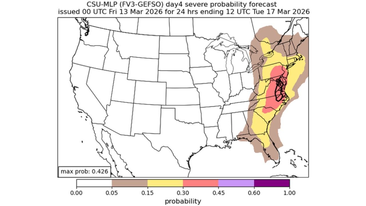
- CSU severe parameter guidance highlights the DC region with elevated severe probabilities.
- CIPS analog-based guidance flags the Mid-Atlantic with historical setups tied to impactful severe events.
These signals suggest the atmospheric pattern is supportive of organized convection across a broad portion of the eastern seaboard.
Timing and Impacts
The cold front is expected to swing through the region Monday, likely during the afternoon and evening hours.
Areas of concern include:
- Washington, DC
- Arlington and Alexandria, Virginia
- Baltimore, Maryland
- Norfolk and coastal Virginia
- Raleigh, North Carolina
The exact timing of frontal passage will influence whether storms intensify during peak heating or encounter a more stable environment.
A Busy Start to the Final Workweek of Winter
With winter officially nearing its end, this system could provide a volatile transition into the final workweek of the season.
Residents in the DC metro area and surrounding Mid-Atlantic states should monitor forecast updates closely through the weekend. Forecast details will sharpen as higher-resolution models begin resolving storm mode and timing.
While it remains several days away, the rare early Enhanced Risk designation signals that this is a setup meteorologists are taking seriously.
Stay with ChicagoMusicGuide.com for continued updates as this developing severe weather threat approaches.