Major Midwest Snowstorm Targets Chicago, Milwaukee and Detroit as Model Differences Raise Questions on Track, Intensity and Snow Totals
CHICAGO, ILLINOIS — A potentially major snowstorm is taking shape across the Midwest, but significant differences between forecast models are creating uncertainty in exactly where the heaviest snow will fall — and just how intense this system may become.
Meteorologists are closely watching notable differences in storm amplitude, north-south track shifts, low pressure intensity and forward speed among leading weather models. These discrepancies will determine whether Chicago and surrounding northern Illinois communities sit in the heart of the snow band — or closer to the rain-snow line.
Key Model Differences Emerging
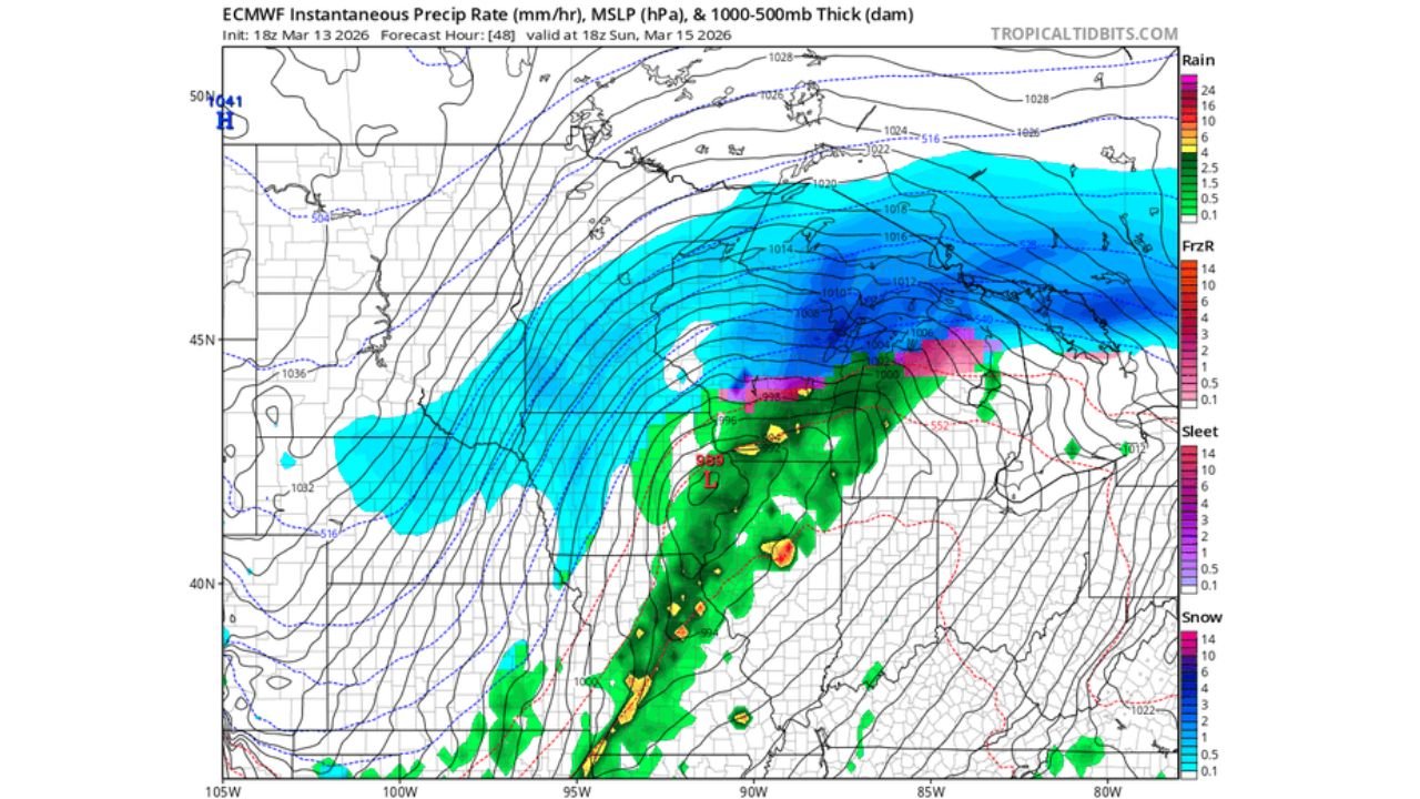
The latest guidance shows the HRRR model depicting a slower, more amplified system tracking farther north compared to other global models.
Specifically:
- The HRRR projects a stronger low pressure center lifting through the central Plains into the Upper Midwest.
- The ECMWF model is also amplified but slightly less aggressive and marginally farther south.
- The AI-based AIFS solution trends weaker and farther south compared to both HRRR and ECMWF.
These differences may appear subtle, but even a 50–100 mile shift in track could dramatically change snowfall totals across Chicago, Milwaukee, Madison and Detroit.
What This Means for Chicago
Under the more amplified and northern solutions, Chicago would remain solidly in the heavy snow shield, with strong deformation banding wrapping across northern Illinois into southern Wisconsin and Michigan.
The HRRR scenario places a deepening low over Iowa or southern Minnesota, pulling a broad swath of heavy snow from eastern Nebraska through Iowa into northern Illinois, southern Wisconsin and Lower Michigan.
That would favor:
- Significant snowfall accumulation in Chicago
- Strong northeast winds
- Potential blowing and drifting snow
- Rapid deterioration in travel conditions Sunday
However, if the weaker and slightly farther south solutions verify, the axis of heaviest snow could shift south and east, potentially placing Chicago closer to the northern edge of the strongest banding.
Late February Blizzard Lessons
Forecasters note that during previous winter storms — including the late February blizzard — high-resolution short-range models sometimes over-amplified systems at longer lead times.
There are concerns the 18z HRRR may be too strong and too far north with this cyclone, especially given that global models often handle synoptic-scale evolution more reliably beyond 48 hours.
For now, consensus still supports a significant snow event across parts of:
- Eastern Nebraska
- Iowa
- Northern Illinois
- Southern Wisconsin
- Lower Michigan
Rain-Snow Line and Mixed Precipitation
South of the low track, warmer air surging northward will bring rain and thunderstorms into parts of Missouri, Illinois and Indiana.
Near the tight temperature gradient, a band of sleet or freezing rain could develop before a full transition to snow.
The exact placement of this transition zone remains one of the largest forecast challenges.
Strong Winds and Blizzard Concerns
Regardless of the exact track, strong pressure gradients surrounding the deepening low will likely produce gusty winds across the Upper Midwest.
If the deeper northern track verifies, portions of Wisconsin and Michigan could experience near-blizzard or blizzard conditions due to:
- Heavy snowfall rates
- Strong winds
- Reduced visibility
Travel disruptions would likely be widespread in that scenario.
Timing
The system is expected to organize Saturday night across the central Plains before intensifying and lifting northeast into Sunday.
Snow would likely overspread Iowa and northern Illinois first before expanding into Wisconsin and Michigan.
Forecast Confidence
While confidence is growing that a significant Midwest winter storm will occur, the details remain fluid.
Residents in Chicago and surrounding suburbs should monitor updated forecasts closely, as small track shifts could alter snow totals dramatically.
Preparation now — especially for those planning travel — is strongly advised.
Stay with ChicagoMusicGuide.com for continuing updates as forecast models converge and confidence increases in the final storm track and snowfall projections.