Virginia, Maryland, Pennsylvania and New Jersey Face Uncertain but Ongoing Damaging Wind Threat as QLCS Evolution Remains in Question
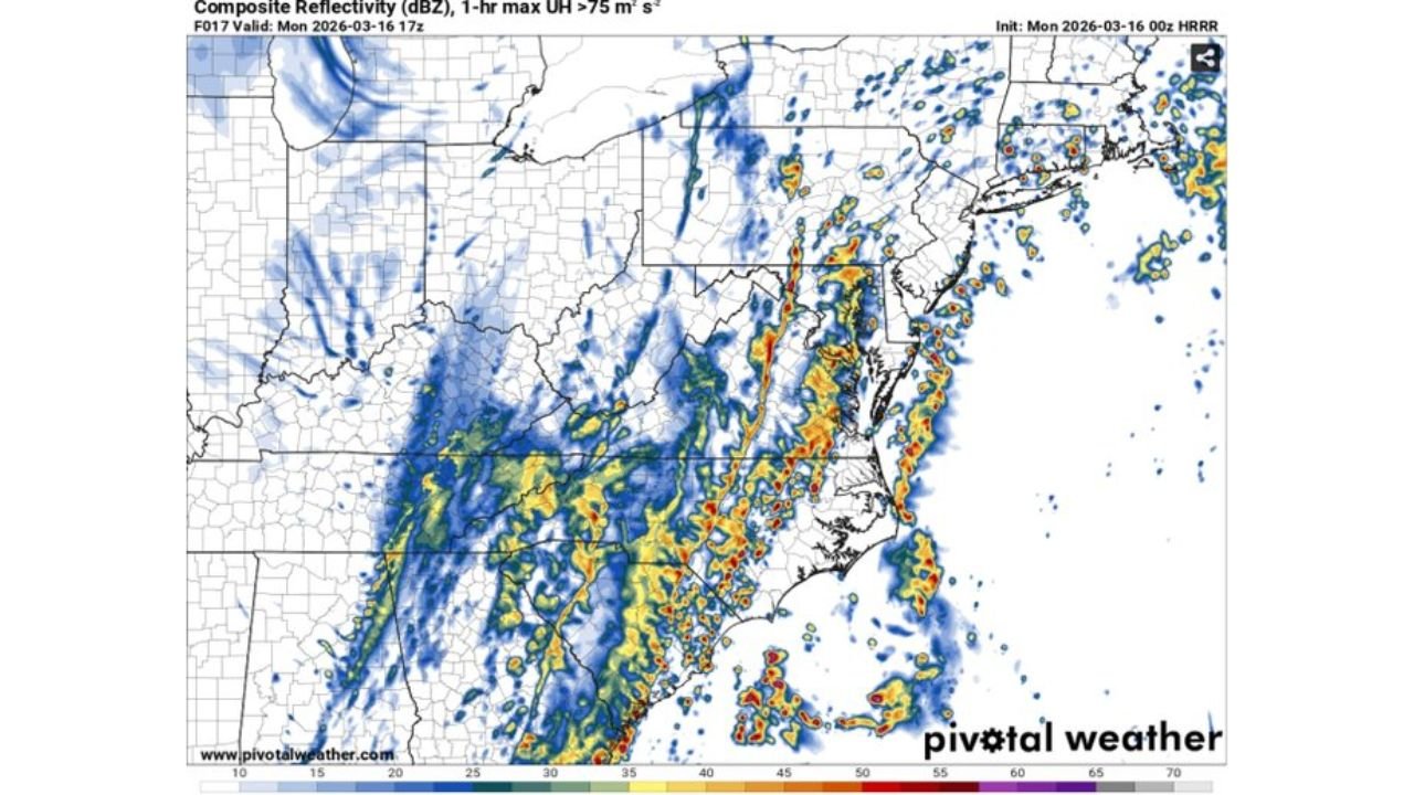
WASHINGTON, D.C., VIRGINIA — Forecast confidence has decreased heading into Monday as meteorologists wrestle with a critical question: what will the overnight QLCS do as it crosses the Appalachian Mountains?
High-resolution models continue to offer a mixed bag of solutions for a powerful line of storms expected to move from the Ohio Valley into the Mid-Atlantic, potentially impacting Virginia, Maryland, Pennsylvania and New Jersey through Monday afternoon.
While the earlier high-end damaging wind scenario is not completely off the table, recent trends suggest the overall severe threat may be lower than previously projected.
Model Disagreement Creates Forecast Challenges Across Virginia and Maryland
Some runs of the HRRR model indicate the line of storms may not weaken significantly as it reaches the mountains of western Virginia and West Virginia. In that case, storms could evolve into a more disorganized mode as the cold front wipes out the warm sector.
That solution favors a more scattered damaging wind threat rather than a concentrated swath of widespread severe wind.
Other model projections show the line weakening overnight west of the Appalachians, then reorganizing east of the mountains by early afternoon. If reintensification occurs, a renewed corridor of stronger winds could develop from:
- Richmond, Virginia
- Washington, D.C.
- Baltimore, Maryland
- Wilmington, Delaware
- Southern New Jersey
- Eastern Pennsylvania
The difference between these outcomes depends heavily on how much instability and moisture can recover east of the mountains.
Moisture and Instability More Favorable Near Coastal Virginia and New Jersey
Forecast data shows the richest surface-based instability remaining closer to the Atlantic coastline, especially across:
- Southeastern Virginia
- Eastern North Carolina
- Coastal Maryland
- Southern New Jersey
Dew points in the upper 50s to low 60s are more prominent near the coast, while inland sections of western Virginia, West Virginia and central Pennsylvania appear more stable.
If deeper moisture fails to push inland, the strongest wind potential may stay confined closer to coastal Virginia, Maryland and New Jersey.
Damaging Wind Still the Primary Threat
Even with increased uncertainty, damaging straight-line winds remain the main hazard across the region.
Model reflectivity projections show a broken but organized line capable of producing strong wind gusts as it pushes northeast through:
- Central and eastern Virginia
- The Washington, D.C. metro area
- Baltimore, Maryland
- Eastern Pennsylvania
- New Jersey
The strongest low-level wind energy appears most favorable near coastal areas, especially across southeastern Virginia and portions of southern New Jersey.
High-End Scenario Lower but Not Eliminated
Earlier outlooks suggested a more significant widespread wind event across Virginia, Maryland, Pennsylvania and New Jersey.
While that high-end outcome appears less likely based on the latest data, it has not been completely ruled out. Subtle overnight changes in storm structure could still allow localized areas of more intense wind damage.
What Residents in Virginia, Maryland, Pennsylvania and New Jersey Should Watch
Key overnight factors include:
- Whether the line maintains intensity crossing the Appalachians
- How quickly storms reorganize east of the mountains
- The degree of surface destabilization by midday
- How far inland higher dew points advance
Residents across Virginia, Maryland, Pennsylvania and New Jersey should remain weather aware through Monday afternoon as forecast details continue to evolve.
Stay with ChicagoMusicGuide.com for ongoing updates as the overnight behavior of this QLCS determines the final impacts across the Mid-Atlantic states.