Maryland and Pennsylvania Storm Line Target Baltimore Metro Between 7 PM and 9 PM With Strong Winds From Frederick and Westminster to Annapolis
BALTIMORE, MARYLAND — A late-night severe weather update indicates the main line of storms associated with a cold front will likely move through the Baltimore, Maryland metro area later than previously expected, with the most organized activity now projected between 7 PM and 9 PM.
While scattered strong or severe storms remain possible during the afternoon, the primary concern centers on the more organized evening line pushing east across central Maryland and southern Pennsylvania.
Evening Timing Shift for Baltimore Metro
Forecast models show the cold front’s main storm line advancing steadily eastward across western Maryland during the evening hours.
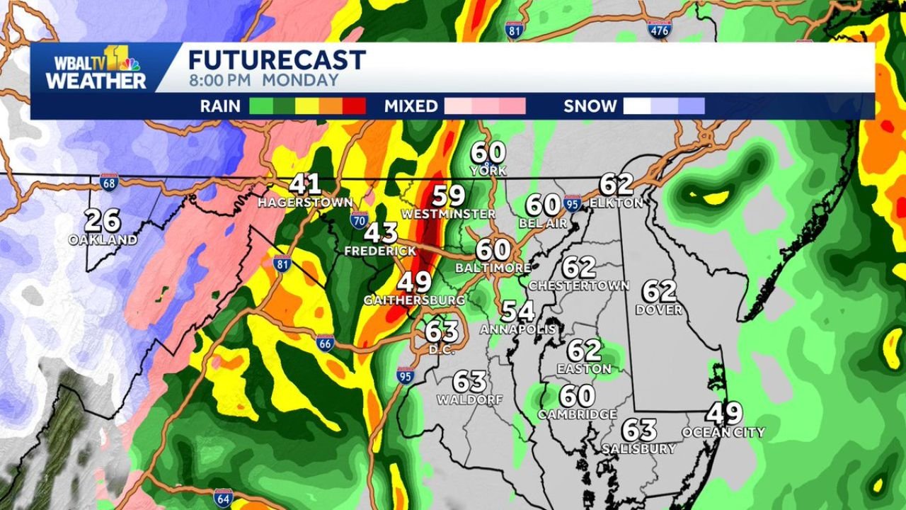
By around 8 PM, the line is expected to extend from:
- Hagerstown, Maryland
- Frederick, Maryland
- Westminster, Maryland
and push directly into:
- Baltimore, Maryland
- Gaithersburg, Maryland
- Annapolis, Maryland
Temperatures ahead of the front remain mild in the upper 50s to low 60s across Baltimore, Bel Air, Elkton, and Dover, Delaware, providing enough instability to support strong thunderstorms.
Western Maryland Sees First Impacts
Earlier in the evening, heavier rain and embedded thunderstorms will affect western communities including:
- Hagerstown, Maryland
- Oakland, Maryland
- Portions of the I-81 corridor
The radar depiction shows a well-defined band of heavy rain (yellows and reds) aligned north-south, indicating a classic frontal squall line structure.
Behind the line, colder air will filter in quickly, with mixed precipitation possible farther west in higher elevations.
Baltimore to Annapolis Corridor at Risk
As the line reaches the I-95 corridor, areas most likely to experience stronger wind gusts include:
- Baltimore
- Gaithersburg
- Columbia
- Annapolis
- Bel Air
While storms during the afternoon may be more scattered and less organized, the evening frontal passage appears more consolidated and capable of producing stronger wind gusts.
Localized heavy rain is also possible as the line passes, particularly where downpours align along the front.
Eastern Shore and Delaware Later in the Night
Communities across Maryland’s Eastern Shore and Delaware, including:
- Chestertown
- Easton
- Cambridge
- Salisbury
- Dover
will likely see the line later in the evening or shortly thereafter, with rainfall and gusty winds shifting eastward.
Severe Threat Details
Forecasters emphasize:
- Strong wind gusts are the primary concern
- Brief heavy rainfall may reduce visibility
- Lightning will be frequent with the main line
- The most organized severe potential is tied to the 7–9 PM window in the Baltimore metro
Although isolated stronger storms cannot be ruled out earlier in the day, they are not expected to be as organized as the evening frontal line.
Conditions Improve After Passage
Once the cold front clears the region later Monday night, conditions should gradually improve from west to east, with cooler and drier air filtering into Maryland and southern Pennsylvania.
Residents across Maryland, Pennsylvania, and Delaware should remain weather-aware through the evening hours and monitor local alerts as the storm line approaches the Baltimore metro.
Stay with ChicagoMusicGuide.com for continuing updates as severe weather tracks across the Mid-Atlantic region.