Texas, Oklahoma, Mississippi and Alabama Lead U.S. in 2026 Severe Thunderstorm Warnings as Midwest and South Face Explosive Storm Season
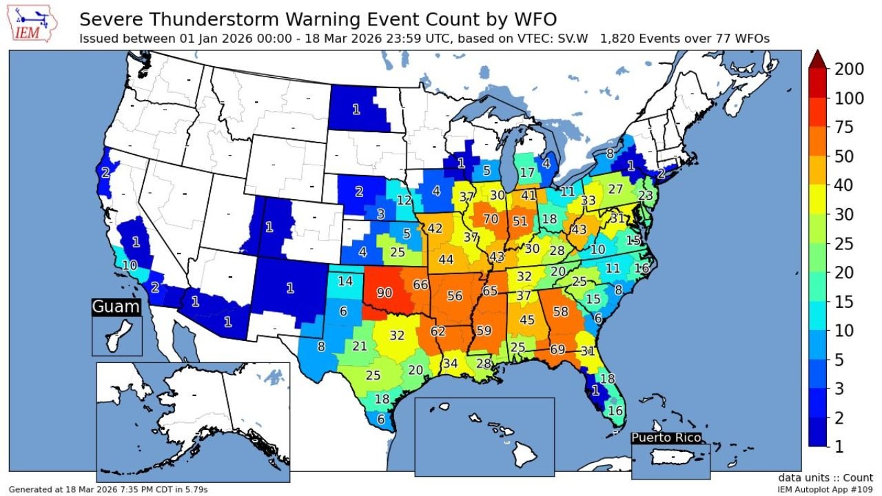
UNITED STATES — A newly released nationwide analysis of Severe Thunderstorm Warnings issued by National Weather Service offices reveals a striking early-2026 pattern: the Southern Plains and Deep South are dominating storm activity, with several states already seeing exceptionally high warning counts.
From Texas and Oklahoma to Mississippi, Alabama, and Arkansas, the data highlights a volatile and active severe weather season unfolding across the central and southeastern United States.
Southern Plains and Deep South Emerging as Storm Epicenter
The highest concentration of warnings is clearly centered across:
- Texas (especially northern and central regions)
- Oklahoma (leading with some of the highest counts nationally)
- Arkansas and Louisiana
- Mississippi and Alabama
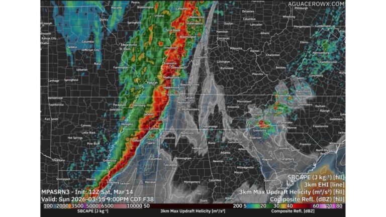
Some areas are already approaching or exceeding 60 to 90 severe thunderstorm warnings, indicating repeated rounds of strong to severe storms.
Oklahoma stands out prominently, with one region recording around 90 warnings, placing it among the most active zones in the country so far this year.
Midwest Also Seeing Elevated Storm Activity
The Midwest corridor is also experiencing a notable surge in severe weather, particularly across:
- Missouri and Illinois
- Indiana and Kentucky
- Tennessee and Ohio Valley regions
Several of these areas are reporting 40 to 70 warnings, suggesting a consistent pattern of storm systems tracking through the region.
This aligns with typical spring transition patterns, where warm Gulf moisture collides with cooler northern air, fueling repeated storm development.
Southeast Continues Active Pattern Into Early 2026
The Southeast is showing widespread moderate to high warning counts, including:
- Georgia and Florida (especially northern Florida)
- South Carolina and North Carolina
While not as extreme as the Plains, these regions are still seeing 20 to 60 warnings, signaling a persistent storm pattern across the region.
Northeast and West Remain Relatively Quiet
In contrast, much of the Northeast and Western United States has seen significantly fewer warnings:
- New York and New England: Mostly under 10–20 warnings
- West Coast (California, Nevada, Arizona): Minimal activity
- Rocky Mountain region: Sparse warning counts
This sharp contrast highlights how storm energy has been concentrated heavily in the central and southern U.S. so far in 2026.
What’s Driving the Active Pattern
Meteorologists point to several contributing factors:
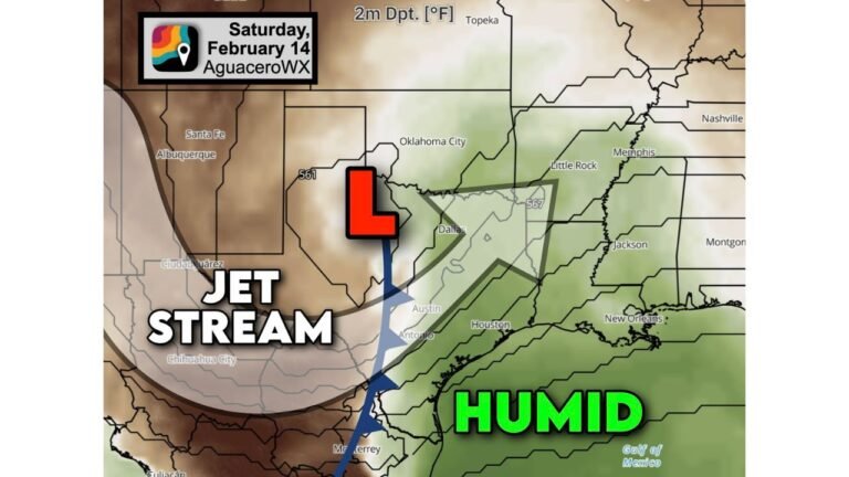
- Persistent jet stream positioning over the central U.S.
- Strong moisture flow from the Gulf of Mexico
- Frequent clashing air masses across the Plains and Midwest
These ingredients have combined to create an environment favorable for repeated severe thunderstorm outbreaks.
What This Means Going Forward
With peak severe weather season still approaching, this early data raises concerns that:
- The central U.S. could see an above-average storm season
- Tornado and damaging wind risks may increase in coming months
- Storm tracks may continue focusing on the same high-impact regions
Communities across Texas, Oklahoma, Arkansas, Mississippi, and Alabama should remain especially alert as the season progresses.
A Warning Sign for an Intense Spring
The current warning totals serve as an early indicator that 2026 could shape up to be a highly active year for severe weather across the United States.
As storm systems continue to develop and track across the country, the focus remains on the Southern Plains and Midwest, where atmospheric conditions remain primed for further outbreaks.
Stay with ChicagoMusicGuide.com for continuing coverage of severe weather trends and real-time updates across the United States.