Texas, New Mexico and Northern Mexico Bake Under Unprecedented Mid-March Heat Dome as California and Arizona Join Rare Early-Season Ridge Event
TEXAS — A powerful upper-level ridge — often referred to as a “heat dome” — has expanded across Texas, New Mexico, northern Mexico, Arizona and parts of California, and meteorologists say the intensity and timing of this event in mid-March is what makes it extraordinary.
While ridges of high pressure are not uncommon, this setup stands out for its strength and structure — particularly for this early in the spring season.
A Ridge More Typical of Summer Than March
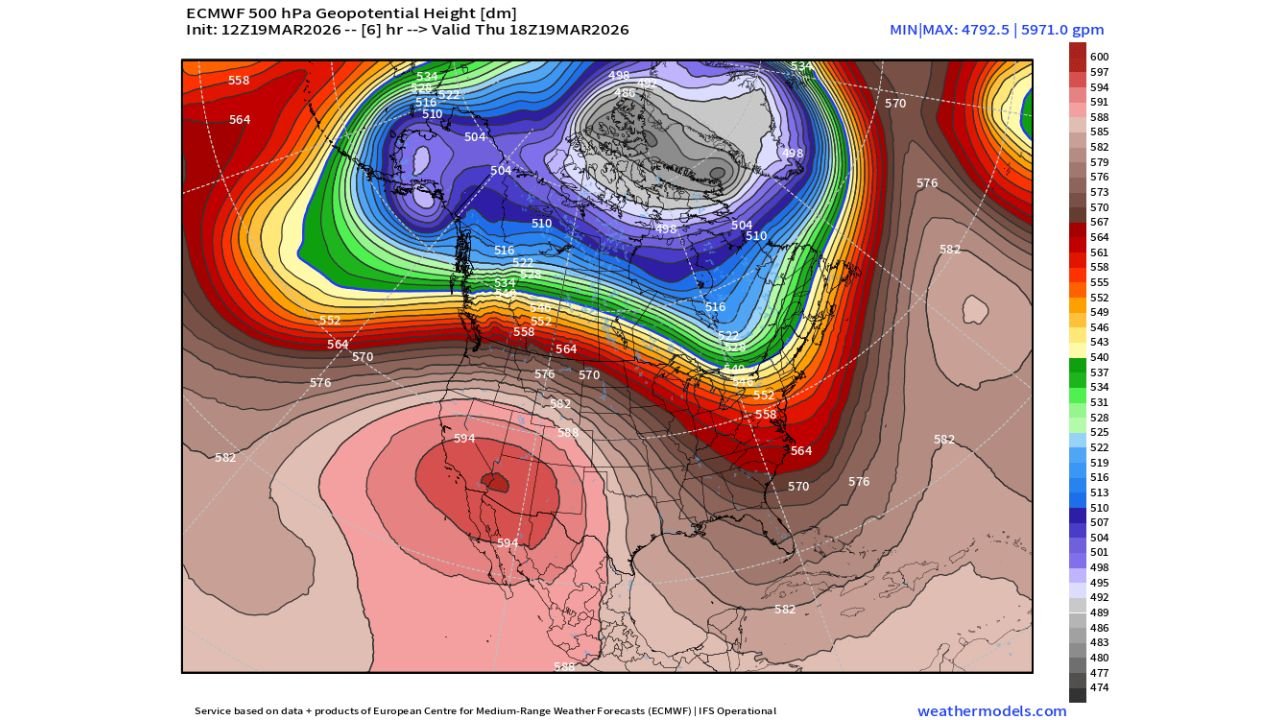
500mb geopotential height maps show a pronounced dome centered over Texas and northern Mexico, with values approaching levels more commonly seen in late spring or summer.
The ridge extends northward into:
- New Mexico
- Arizona
- Southern California
- Parts of Nevada
Such high mid-level heights in mid-March suggest unusually warm air aloft, which translates to:
- Strong subsidence (sinking air)
- Suppressed cloud formation
- Intensified surface heating
Why This Heat Dome Is Different
The key factor is not just the presence of the ridge, but its interaction with the broader North American pattern.
To the north, a deep trough and cold-core circulation are entrenched across Alaska, western Canada and central Canada, creating a sharp atmospheric contrast between extreme cold in the north and unusual warmth in the south.
This amplified pattern — featuring:
- A strong western and southwestern ridge
- A pronounced Canadian trough
- Tight height gradients across the central U.S.
— is helping lock the ridge in place and intensify its effects.
Meteorologists describe this kind of configuration as highly amplified, meaning the jet stream is dramatically buckled rather than flowing west-to-east in a flatter pattern.
Texas at the Center of the Heat
The most concentrated height anomalies appear centered over:
- Central and South Texas
- Northern Mexico
- West Texas into the Permian Basin
Underneath this dome, daytime temperatures can surge well above seasonal averages, particularly where skies remain clear and winds are light.
Mid-March heat waves in Texas are not unheard of, but the magnitude of the upper-level support behind this event is what forecasters are flagging as potentially “unseen” for this time of year.
California and Arizona Also Impacted
The ridge also extends west into:
- Southern California
- Arizona
- Southern Nevada
These areas may see above-normal warmth, though the most extreme core remains centered farther east.
The Bigger Story: An Amplified Jet Stream
What makes this setup meteorologically compelling is the storyline:
- Extreme warmth building in the Southwest and Texas
- Deep cold pooling across Canada
- A sharply curved jet stream separating the two
This creates a classic “ridge and trough” couplet — but with unusually high amplitude for mid-March.
Such amplified patterns can also downstream influence storm tracks across the Midwest and East, increasing volatility in other regions while the Southwest bakes under stable conditions.
Not Just a Warm Spell — A Signal Event
Heat domes are part of normal atmospheric variability. However, the combination of:
- Intensity
- Early-season timing
- Strong upper-level heights
- Locked-in pattern amplification
is what sets this event apart.
From Texas and New Mexico through Arizona and southern California, residents are experiencing a ridge more typical of late spring than late winter.
Stay with ChicagoMusicGuide.com for continued updates as this unusual mid-March heat dome evolves and influences weather patterns across the broader United States.