Pittsburgh to Harrisburg to Allentown: Severe Storms Set to Sweep Pennsylvania Sunday Afternoon and Evening with Damaging Wind, Hail and Isolated Tornado Risk
STATE COLLEGE, PENNSYLVANIA — Severe thunderstorms are expected to develop and sweep across Pennsylvania on Sunday, with the greatest threat unfolding from the afternoon into the evening hours.
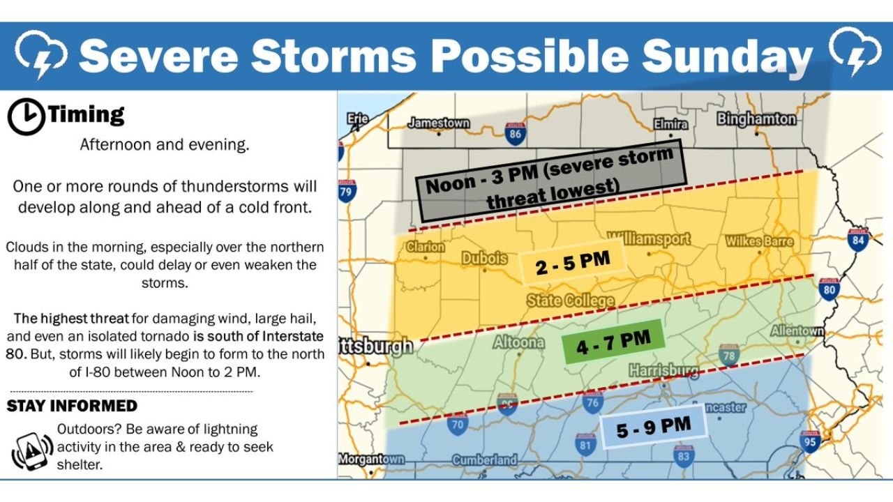
The National Weather Service indicates that one or more rounds of thunderstorms will form along and ahead of an approaching cold front, bringing the potential for damaging wind gusts, large hail, and even an isolated tornado, particularly south of Interstate 80.
Storm Development Begins North, Intensifies South
According to the latest timing outlook, storms are likely to first initiate across northern Pennsylvania between Noon and 2 PM, where the severe threat is expected to be lower.
Areas near Clarion, Dubois, and Williamsport could see early development from Noon to 3 PM, though instability may be somewhat limited initially.
By 2 PM to 5 PM, stronger storms are expected to organize and move through central portions of the state, including State College and surrounding communities.
Highest Risk: South of Interstate 80
The greatest severe weather threat is forecast to focus south of I-80, where atmospheric conditions will be more favorable for robust storm development.
Between 4 PM and 7 PM, storms are projected to impact areas including:
- Altoona
- Harrisburg
- Portions of the I-76 and I-81 corridors
During this window, the potential for damaging straight-line winds and large hail increases significantly.
Evening Threat Shifts Southeast
By 5 PM to 9 PM, the strongest storms are expected to push into southeastern Pennsylvania, including:
- Lancaster
- Areas east toward the I-83 corridor
- Communities approaching the Philadelphia metro region
This late-day period may feature the most intense activity as storms consolidate and track southeastward.
Isolated Tornado Cannot Be Ruled Out
While damaging winds and large hail are the primary concerns, forecasters note that an isolated tornado cannot be ruled out, especially in the higher-risk zone south of I-80.
Cloud cover during the morning, particularly across northern Pennsylvania, may slightly delay or weaken early storm development, but once storms strengthen during peak heating, severe potential will increase.
Multiple Rounds Possible
The setup suggests the possibility of more than one round of thunderstorms, meaning some communities could see repeated periods of heavy rain and lightning.
Residents across Pittsburgh, State College, Altoona, Harrisburg, and southeastern Pennsylvania should remain alert through Sunday afternoon and evening.
Having multiple ways to receive weather warnings and being prepared to seek shelter quickly if a warning is issued will be critical.
As the cold front sweeps through and storms organize, Pennsylvania faces a classic late-day severe weather scenario — one that could bring impactful conditions from the western part of the state to the east by nightfall.
For continuing coverage of severe weather threats across the Midwest and Mid-Atlantic, stay with ChicagoMusicGuide.com.