Repeated Storm Systems Set to Impact Illinois, Indiana, Ohio and Michigan With Multiple Rounds of Rain and Severe Weather Threats From March 26 Through April 5
MIDWEST — A series of storm systems is lining up to impact Illinois, Indiana, Ohio and Michigan from late March into the first week of April, bringing multiple rounds of rain and the potential for severe weather across the region.
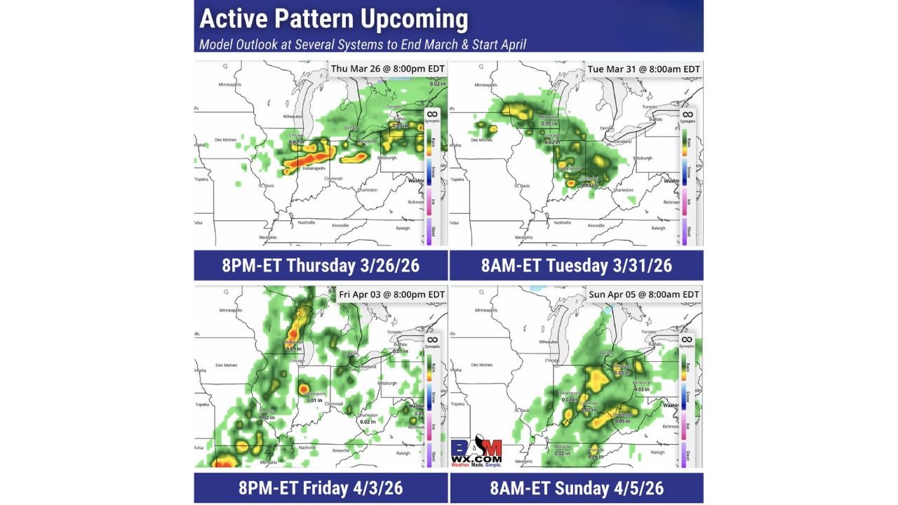
Forecast model snapshots show an active pattern unfolding between March 26 and April 5, with several waves of precipitation moving through the Midwest and Great Lakes.
Thursday Night, March 26: Storms Push Across Illinois and Indiana
By 8 p.m. EDT Thursday, March 26, a band of showers and embedded thunderstorms stretches from central Illinois into Indiana and western Ohio.
Heavier pockets appear near:
- Chicago, Illinois
- Indianapolis, Indiana
- Areas west of Cleveland, Ohio
The setup suggests a corridor of steady rain with localized heavier downpours. Given the late-March instability typical with strengthening spring systems, strong storms cannot be ruled out in parts of Illinois and Indiana.
Tuesday Morning, March 31: Rain Expands Across the Great Lakes
By 8 a.m. EDT Tuesday, March 31, the next system spreads rain across:
- Northern Illinois
- Indiana
- Ohio
- Southern portions of Michigan
The coverage becomes more widespread compared to the March 26 event, indicating a broad shield of rain rather than isolated cells. Cities including Chicago, Indianapolis and Detroit appear within steady precipitation zones.
This reinforces the idea that the pattern is not a single storm but part of a sustained shift toward a wetter regime.
Friday Night, April 3: Another Wave Through the Midwest
At 8 p.m. EDT Friday, April 3, another disturbance moves through the region. Showers redevelop across:
- Illinois
- Indiana
- Ohio
- Western Michigan
Some heavier cores appear near Indianapolis and parts of northern Illinois. The repeated nature of these systems increases the chance of saturated ground conditions, especially where earlier storms deliver heavier rainfall.
Sunday Morning, April 5: System Targets Ohio Valley and Great Lakes
By 8 a.m. EDT Sunday, April 5, yet another round of rain is depicted moving through:
- Eastern Indiana
- Ohio
- Southern Michigan
Cleveland and surrounding areas sit beneath moderate rain bands, while additional activity extends southwest toward Kentucky and Tennessee.
This fourth system in roughly 10 days underscores the persistence of the active pattern.
What This Means for the Midwest
The sequence from March 26 through April 5 points to:
- Multiple storm tracks across Illinois, Indiana, Ohio and Michigan
- Frequent rain chances
- Periodic heavier downpours
- Potential severe weather episodes depending on storm timing and instability
While exact placement will likely shift in updated forecasts, the overarching theme remains consistent — a busy stretch of spring weather rather than a quiet transition into April.
For cities like Chicago, Indianapolis, Detroit and Cleveland, this pattern signals repeated interruptions from rain and thunderstorms, with limited dry stretches between systems.
ChicagoMusicGuide.com will continue monitoring how this evolving late-March and early-April storm pattern impacts the Midwest as updated data becomes available.