Chicago, Illinois Faces Sharp 30 to 40 Degree Temperature Drop as Powerful Cold Front Splits Midwest Heat Thursday
CHICAGO, ILLINOIS — A powerful cold front is expected to sweep across the region Thursday, bringing a dramatic 30 to 40 degree temperature drop across parts of Illinois, Indiana, and southern Michigan. Ahead of the front, temperatures are forecast to surge into the 80s and low 90s, only to fall sharply into the 40s and 50s once the boundary passes.
This sharp contrast in air masses will create one of the most noticeable temperature swings of the early spring season, especially across the Chicago metro area and surrounding Midwest cities.
Warm Air Surges Before the Cold Front Arrival
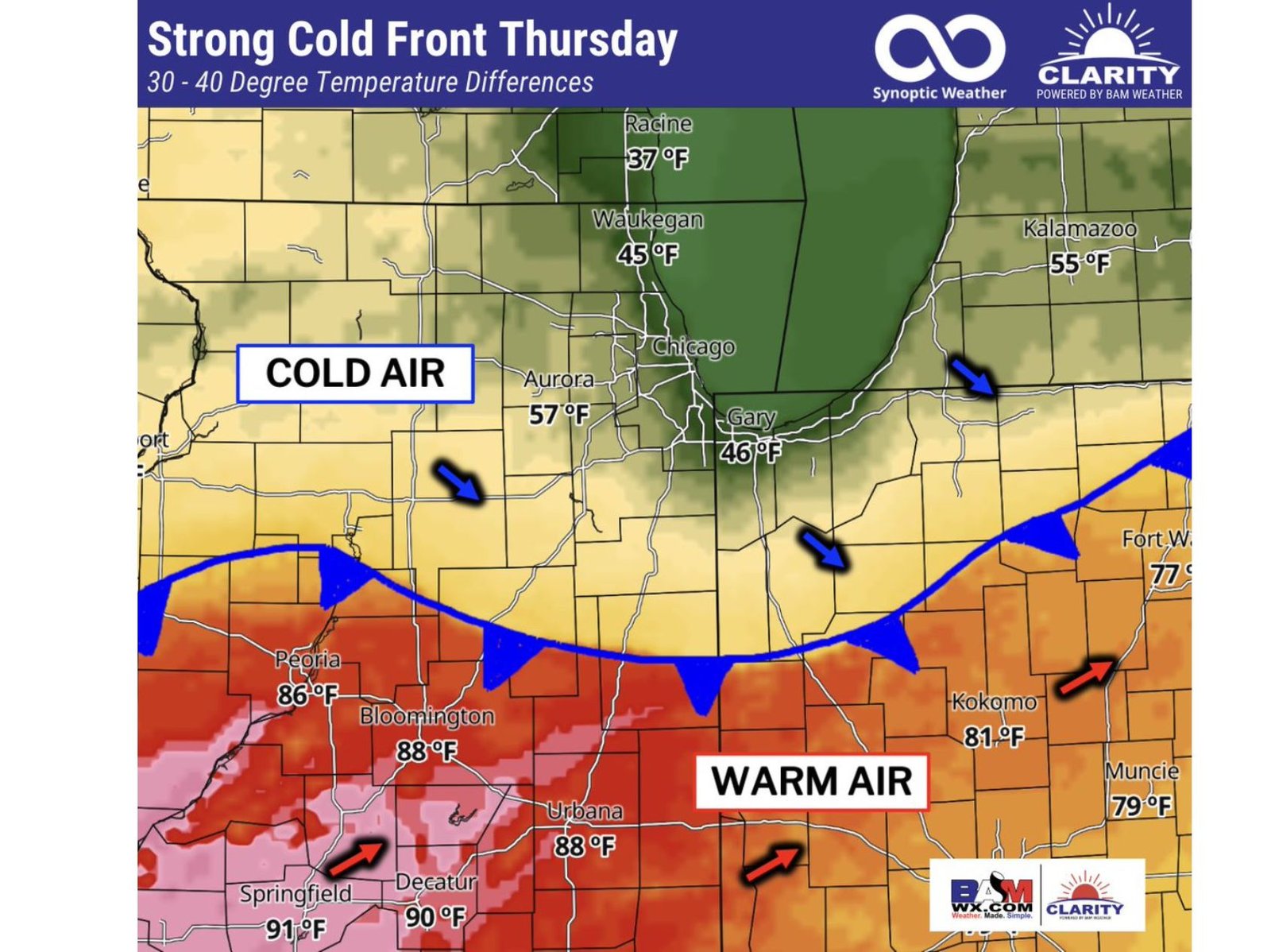
Before the arrival of the cold front, much of central and southern Illinois will be firmly locked in a warm air mass, with cities like Springfield, Decatur, Urbana, and Bloomington seeing temperatures climb into the upper 80s and even low 90s.
This surge of warmth is part of a broader pattern pushing spring-like heat northward into the Midwest, creating a stark boundary between hot southern air and cooler northern air. Areas just south of Chicago, including portions of central Illinois and Indiana, will feel the peak of this warmth during the daytime hours.
Even parts of Indiana, such as Kokomo and Muncie, are expected to reach into the upper 70s to low 80s, reinforcing the strength of the warm sector ahead of the front.
Cold Air Rushes In Behind the Front
As the cold front advances, temperatures will drop rapidly across northern areas, especially near Chicago, Waukegan, Gary, and Racine. Forecast values show readings falling into the mid-40s near Waukegan, upper 30s near Racine, and mid-40s around Gary, marking a dramatic shift within just a few hours.
This sudden transition highlights the intensity of the front, as it slices between summer-like warmth and much cooler spring air. Areas north of the boundary will quickly transition into a cooler, more stable air mass, bringing an abrupt end to the earlier warmth.
The Chicago region sits directly in the path of this boundary, meaning residents could experience a rapid temperature drop during the day, depending on the exact timing of the front’s passage.
Sharp Temperature Gradient Marks the Front’s Position
One of the clearest indicators of the cold front’s location will be the sharp temperature gradient across short distances. For example, temperatures in Peoria and Bloomington may remain in the mid-to-upper 80s, while areas just north, including Aurora, may already drop into the upper 50s.
This kind of temperature contrast over a relatively small geographic area is a classic signature of a strong frontal boundary, and it often plays a role in triggering weather changes, including cloud development and potential storm activity.
The front is expected to stretch across Illinois into northern Indiana, creating a dividing line between warm air to the south and cooler air to the north, with the boundary steadily pushing southeast through the day.
What This Means for Chicago and the Midwest
For residents in Chicago and surrounding Midwest communities, Thursday will likely feel like two different seasons in one day. Morning or early afternoon warmth could quickly give way to cool, breezy conditions, especially as the front moves through.
This kind of rapid temperature change can also impact travel, outdoor plans, and evening conditions, as temperatures drop significantly after sunset. Cities across Illinois, Indiana, and southern Michigan should prepare for quick weather shifts and noticeable cooling.
The strength of this system also reinforces a broader pattern of volatile spring weather, where strong temperature swings become more common as seasonal transitions take hold.
As this strong cold front moves through the Midwest, staying updated on changing conditions will be important for residents across Chicago, Illinois, and neighboring states. For more updates on regional weather patterns, temperature swings, and severe weather risks, visit ChicagoMusicGuide.com.