Illinois Counties Including Will and Kendall Face Enhanced Severe Storm Risk With Large Hail and Damaging Winds Near Chicago Thursday
ILLINOIS — An enhanced risk for severe weather has been issued for parts of northern and central Illinois, including Will and Kendall Counties, as storms are expected to develop Thursday afternoon and continue into the evening. The Chicago region sits within a zone where storms could bring heavy rainfall, frequent lightning, damaging winds, and large hail potentially up to baseball size.
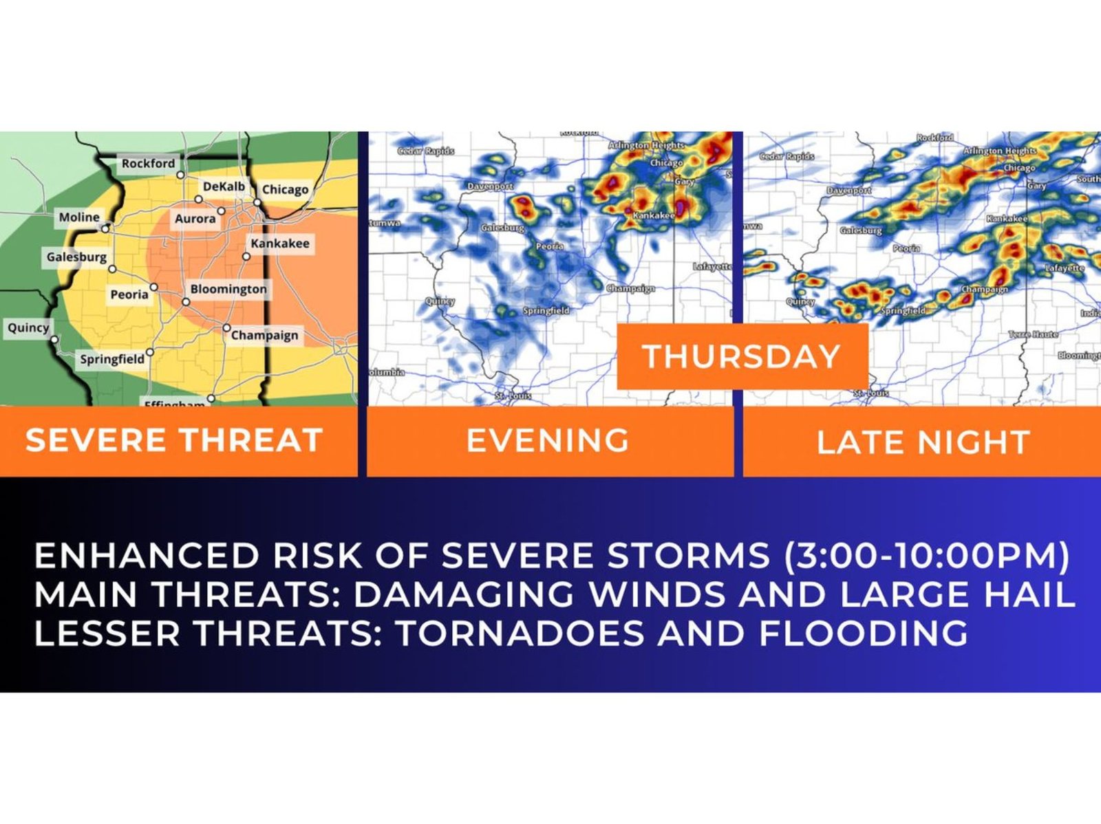
The most active window for severe weather is expected between 3:00 PM and 10:00 PM, with conditions evolving rapidly as a cold front pushes through northern Illinois.
Severe Storm Threat Builds Across Northern Illinois
Storms are expected to develop across northern and central Illinois, including areas near Chicago, Aurora, Joliet, Kankakee, and DeKalb, as warm and unstable air fuels storm growth. The environment ahead of the front supports strong thunderstorm development, with the potential for storms to intensify quickly.
The primary concern during the early stages will be large hail, with some storms capable of producing hail up to baseball size, which can cause damage to vehicles, roofs, and outdoor property. In addition, storms will bring heavy downpours and frequent lightning, creating hazardous conditions for travel and outdoor activities.
The enhanced risk level highlights a greater likelihood of severe weather compared to typical storm days, especially across counties southwest of Chicago, where conditions are most favorable.
Damaging Winds Become Primary Evening Threat
As storms progress into the evening hours, they are expected to become more organized, shifting the primary concern toward damaging winds. Storms may merge or form clusters, allowing wind impacts to spread across a wider area.
Communities in Will County, Kendall County, and surrounding parts of northern Illinois could experience strong wind gusts capable of downing tree limbs and causing localized power outages. This transition from isolated storms to more widespread impacts is a key feature of Thursday’s setup.
The potential for rapid storm movement also increases the risk of impacts occurring quickly, with limited time between warnings and storm arrival.
Lower Tornado and Flood Risk Still Present
While the main threats focus on hail and damaging winds, there remains a lower but non-zero risk for tornadoes and localized flooding. The risk of tornadoes is expected to decrease as cooler air moves into the region, reducing the instability needed for tornado development.
However, during the early phase of storm development, especially in the warm sector ahead of the front, a brief tornado cannot be completely ruled out. Similarly, heavy rainfall could lead to localized flooding in areas where storms repeatedly track.
This combination of risks makes it important for residents across northern and central Illinois to stay alert throughout the day.
Temperature Contrast Adds to Storm Intensity
A key factor in Thursday’s setup is the sharp contrast in temperatures across northern Illinois, with warm air ahead of the front and cooler air moving in behind it. This temperature difference helps enhance storm development by creating instability along the frontal boundary.
The day is expected to begin with mild to warm conditions, but temperatures will begin to fall as the front moves through, signaling a shift toward cooler weather later in the evening.
This type of setup has been seen in recent weeks across the region, where strong fronts have triggered severe weather followed by rapid cooling, making conditions highly dynamic.
What Residents in Illinois Should Expect
For residents in Will County, Kendall County, and the greater Chicago area, Thursday will bring a multi-phase severe weather event, beginning with hail-producing storms in the afternoon and transitioning to damaging winds in the evening.
The enhanced risk designation means higher confidence in severe weather occurrence, and residents should be prepared for rapid changes in conditions, especially during the late afternoon and evening hours.
With storms expected to impact a wide portion of northern and central Illinois, staying informed and having a plan in place will be critical as conditions develop.
As severe weather moves into Illinois and the Chicago region, staying updated on alerts and forecasts will be essential for safety. For more coverage on Midwest storms, severe weather alerts, and Chicago forecasts, visit ChicagoMusicGuide.com.