California Population Map Reveals San Francisco, Los Angeles, and San Diego Regions Each Hold Major Share of State Residents
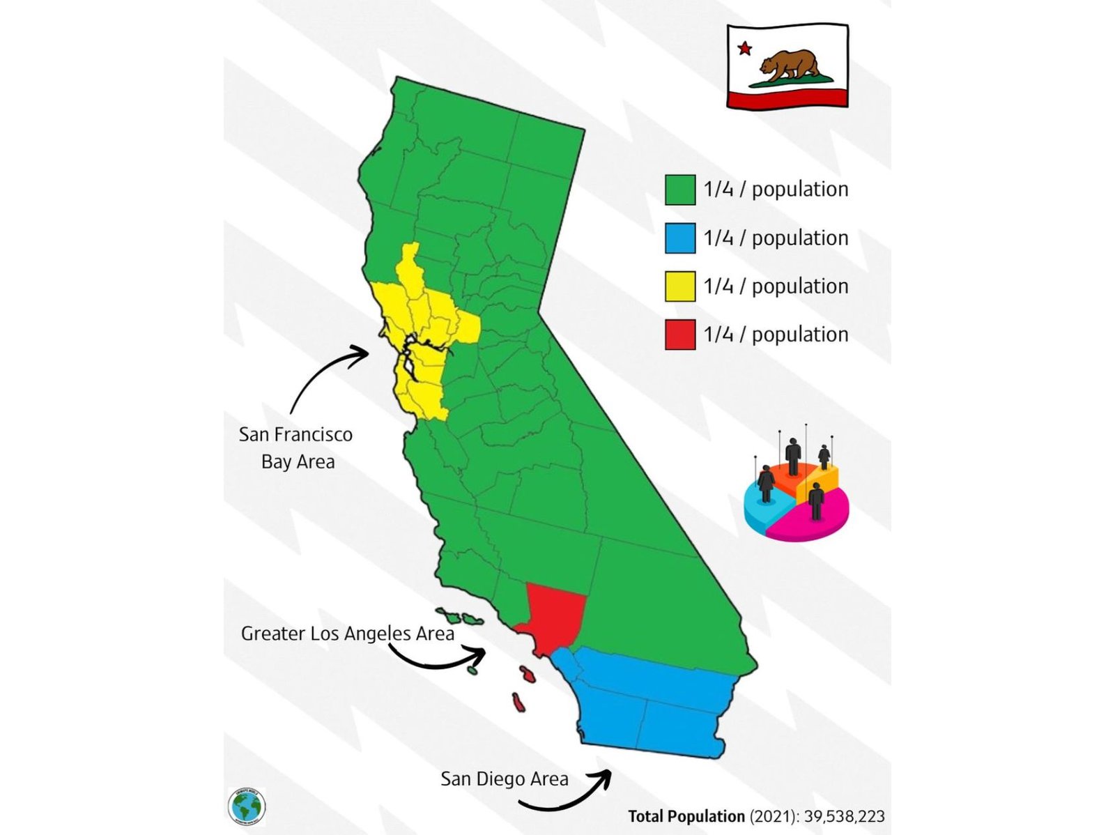
CALIFORNIA — A newly circulated population map highlights how California’s nearly 40 million residents are distributed across key regions, showing that the San Francisco Bay Area, Greater Los Angeles, and San Diego area each account for roughly a quarter of the state’s population, with the remaining population spread across the rest of the state.
The visualization provides a simplified but striking look at how population density is concentrated in specific urban hubs, leaving much of the state geographically large but comparatively less populated.
Bay Area Emerges as One of the State’s Population Centers
The San Francisco Bay Area stands out as one of the four major population zones, representing approximately one-quarter of California’s total population. This region includes major urban and suburban areas surrounding San Francisco, Oakland, and San Jose, where economic activity and job opportunities have historically drawn large numbers of residents.
Despite occupying a relatively smaller geographic footprint compared to other parts of the state, the Bay Area’s high population density reflects its role as a major economic and cultural center. The clustering of counties in this region highlights how population is concentrated around coastal urban corridors rather than spread evenly inland.
This concentration also underscores ongoing challenges such as housing demand, infrastructure pressure, and cost of living, which are common in densely populated metropolitan areas.
Greater Los Angeles Holds Significant Population Share
The Greater Los Angeles area is another key region identified in the map, accounting for its own quarter share of California’s population. This includes Los Angeles County and surrounding metropolitan areas, which together form one of the largest urban regions in the United States.
Unlike the Bay Area, the Los Angeles region spans a broader geographic area, but still maintains extremely high population density, especially in urban and suburban communities. The map emphasizes how this region serves as a central hub for entertainment, business, and cultural influence, attracting residents from across the country and internationally.
The concentration of population in this area also contributes to traffic congestion, urban sprawl, and resource demands, making it one of the most complex metropolitan regions in the nation.
San Diego Region Represents Another Major Population Block
Further south, the San Diego area is shown as a distinct population zone, also accounting for roughly one-quarter of the state’s residents. While smaller in size compared to Los Angeles, the region remains a significant population center with a strong mix of urban development, coastal living, and economic growth.
The map highlights how southern California continues to dominate population distribution, with both Los Angeles and San Diego contributing heavily to the state’s overall population totals.
San Diego’s growth reflects its appeal as a coastal city with a strong economy, attracting residents seeking both job opportunities and quality of life.
Remaining Population Spread Across Vast Interior Regions
The final quarter of California’s population is distributed across the rest of the state, which includes large inland areas, rural regions, and smaller cities. Despite covering the majority of California’s land area, these regions collectively hold a smaller share of the population compared to the major urban centers.
This contrast between geographic size and population density is one of the most notable takeaways from the map. While much of California appears expansive, the majority of residents are concentrated in key metropolitan corridors along the coast and select inland hubs.
This distribution pattern has significant implications for infrastructure planning, transportation, housing, and economic development, as resources must be balanced between densely populated cities and sparsely populated regions.
What This Population Breakdown Reveals About California
The map provides a simplified but powerful snapshot of how California’s population is structured, showing a clear divide between high-density urban centers and less populated rural areas. The fact that four distinct regions each hold roughly equal shares of the population illustrates how concentrated growth has become in specific parts of the state.
With a total population of approximately 39.5 million residents, California remains one of the most populous and diverse states in the country. Understanding how that population is distributed helps explain broader trends in housing, transportation, and regional development.
As discussions around growth and infrastructure continue, insights like these offer a clearer picture of where people live and how the state continues to evolve.
For more insights into regional trends, data-driven stories, and updates across the United States, visit ChicagoMusicGuide.com.