Ohio, Indiana and Western Ohio Supercell Moves In With Large Hail Threat and Increasing Tornado Risk Through Evening Hours
OHIO, INDIANA — A dangerous supercell thunderstorm is pushing into western Ohio from eastern Indiana this evening, initially producing large hail but showing signs of entering a more supportive environment for tornado development over the next several hours.
The storm, already well-organized, is being closely monitored as it moves through communities near the Ohio-Indiana border, with conditions expected to evolve rapidly as temperatures cool and atmospheric dynamics strengthen.
Large Hail Currently the Primary Threat Across Western Ohio
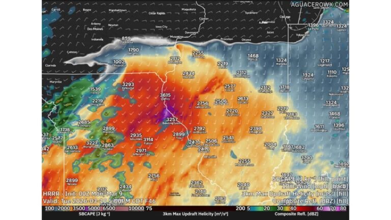
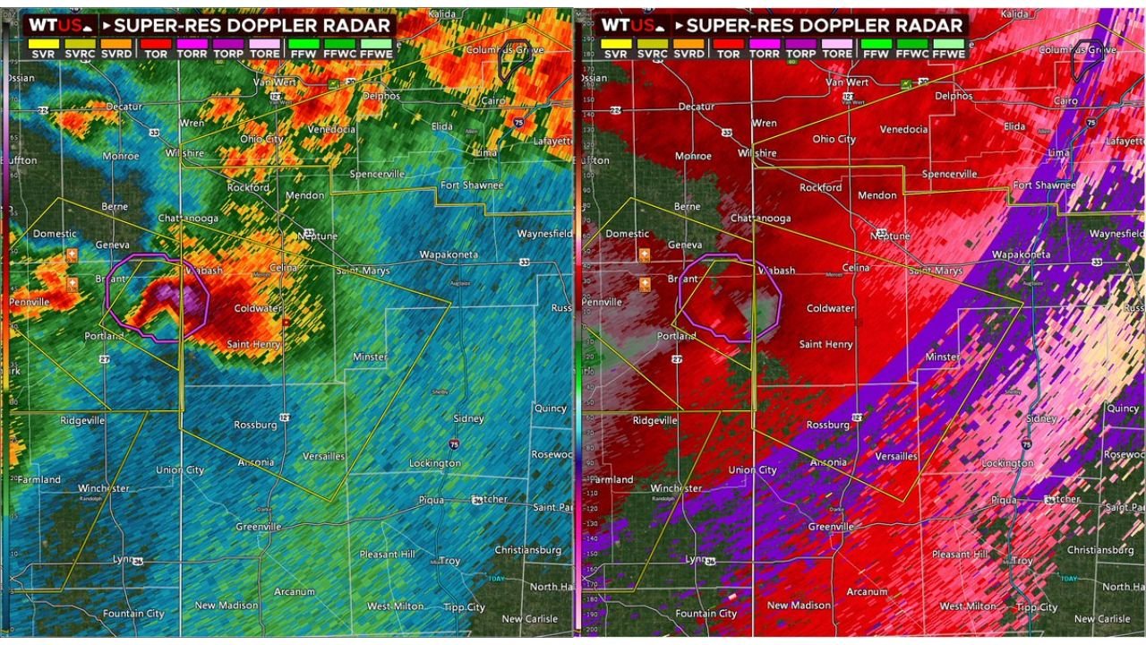
At this stage, the dominant hazard associated with the supercell in western Ohio is large hail, with radar imagery showing a strong and compact storm core capable of producing significant impacts. Areas including Celina, Coldwater, and Wapakoneta in Ohio, along with nearby parts of eastern Indiana, are within the immediate path of this system.
The presence of relatively high dew point depressions is currently limiting the storm’s ability to fully transition into a tornado-producing structure. This means the storm is still somewhat elevated, favoring hail production over low-level rotation.
However, even in this phase, the storm remains dangerous, with the potential for damaging winds and intense lightning increasing as it continues to organize.
Tornado Potential Increasing as Environment Improves
As the evening progresses, forecasters note that conditions across western Ohio are becoming more favorable for tornado development. The key factors include cooling temperatures and strengthening low-level wind shear, which can help storms transition into surface-based systems.
If this supercell becomes surface-based, it could quickly begin to rotate more efficiently, increasing the likelihood of tornado formation. The current trajectory suggests that areas deeper into central Ohio could face a heightened risk later in the evening.
This transition is critical, as it marks the shift from a hail-dominant storm to a multi-hazard severe weather event, including the potential for tornadoes, damaging winds, and continued large hail.
Storms Expected to Grow and Become More Organized
In addition to the ongoing supercell, storm activity across Ohio and Indiana is expected to become more widespread and organized through the evening hours. As storms merge and grow upscale, the risk will shift toward a broader damaging wind event, while still maintaining pockets of large hail and isolated tornado potential.
This evolution could lead to a more continuous line of storms impacting a larger portion of the region, including cities such as Dayton, Lima, and possibly Columbus, Ohio.
Residents in both Ohio and Indiana should remain alert as conditions can change quickly, especially with storms transitioning into a more favorable environment for severe weather.
What Residents in Ohio and Indiana Should Watch Closely
The next few hours will be critical in determining the overall severity of this event. Key factors to monitor include whether the storm becomes fully surface-based and how quickly low-level rotation intensifies.
Even if tornado development remains limited, the continued threat of large hail and damaging winds will pose significant risks to property and travel. Power outages and localized damage are possible as storms intensify and expand.
People across western and central Ohio, as well as eastern Indiana, are urged to stay weather-aware and be prepared to take action if warnings are issued.
For continued updates on severe weather threats, storm tracking, and regional forecasts, visit ChicagoMusicGuide.com for the latest coverage and alerts.