Kansas, Oklahoma and Texas Residents Are Seeing Alarming April 5 Storm Maps Online but the More Reliable Forecast Data Tells a Very Different Story
OKLAHOMA CITY, OK — There is a storm pattern being circulated across social media right now for next Sunday, April 5th — and it looks dramatic. A deep, intense upper-level low parked over the southwestern Plains with massive negative height anomalies screaming severe weather potential across Kansas, Oklahoma and Texas. It is the kind of map that gets shared thousands of times and sends the weather community into a frenzy.
Here is what you actually need to know: that map is almost certainly not what April 5th looks like.
The ECMWF deterministic model — the single-run solution that produces that dramatic blue bullseye over New Mexico and western Texas — is telling a story that the ECMWF ensemble mean flatly disagrees with. And in extended-range forecasting, the ensemble is the more reliable guide. Always.
Understanding the Two Maps — Why They Look So Different
Before breaking down what each map is showing, it helps to understand what a deterministic model versus an ensemble mean actually represents — because this distinction is the entire story of this forecast.
A deterministic model run is a single simulation of the atmosphere. It picks one specific set of initial conditions and runs them forward in time to produce one specific forecast. At short ranges — 24 to 48 hours — deterministic models are highly valuable. At 8 days out, a single deterministic run is essentially one possibility among dozens of plausible outcomes. It can be spectacularly right. It can also be spectacularly wrong.
An ensemble mean takes 50 or more separate model runs, each initialized with slightly different starting conditions, and averages them together. The ensemble mean smooths out the extreme solutions — the outliers that any single run might produce — and gives you the most probable atmospheric state at a given time. At extended range, the ensemble mean is the number you bank on. The deterministic run is the number you hope for — or fear.
What the Deterministic Run Is Showing for April 5th
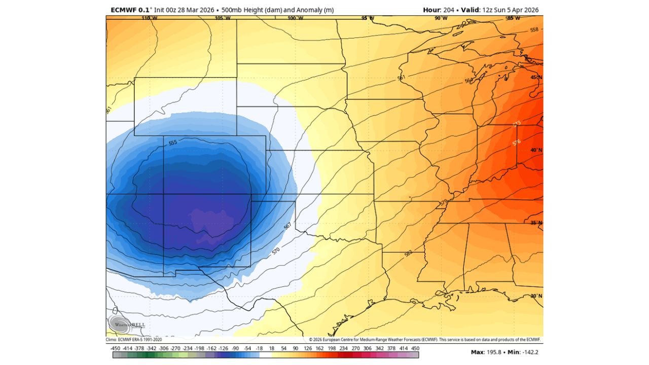
The ECMWF deterministic 0.1° model, initialized 00z March 28, valid 12z April 5, is showing a closed upper-level low centered over New Mexico and western Texas with a height anomaly of -142.2 meters at its core — shown by the deep blue and purple bullseye on the map.
To put that anomaly in perspective: -142 meters at 500 mb is an extraordinarily deep negative anomaly. It represents an upper-level trough that is dramatically colder and lower than anything close to climatological norms for early April across the southwestern Plains. A trough of that depth and position, if it verified, would create a textbook severe weather setup for Kansas, Oklahoma and potentially Missouri as the system ejects northeast — with tornado, large hail and damaging wind threats across the full Tornado Alley corridor.
The eastern half of the map simultaneously shows strongly positive height anomalies across Illinois, Indiana, Ohio and the Mid-Atlantic — values reaching +195.8 meters at the maximum. This contrast between the deep western trough and the amplified eastern ridge is exactly the kind of pattern that forces jet stream energy to accelerate rapidly across the Plains — a classic severe weather amplifier.
This is the map that is being shared. This is the map that looks terrifying for the southern Plains. And this is the map that the ensemble is saying is too aggressive.
What the Ensemble Mean Is Actually Showing
The ECMWF Ensemble Mean at 0.25° resolution, initialized at the same 00z March 28 time, valid at the identical 12z April 5 window, tells a completely different story.
The dramatic blue bullseye over New Mexico? Gone. The deep closed low centered over the southwestern Plains? Replaced by a much weaker, more diffuse negative anomaly showing only a modest blue tint across the northern Plains — Nebraska, South Dakota and into the Great Lakes. The maximum negative anomaly on the ensemble mean map is only -24.4 meters — compared to -142.2 meters on the deterministic run. That is not a small difference. That is the ensemble telling you the deterministic run has produced an extreme outlier solution.
The ensemble mean for April 5th shows a pattern dominated by above-normal heights — warm and relatively benign conditions — across most of the southern Plains, Texas, Oklahoma and Kansas. The modest negative anomaly is displaced far to the north across the upper Midwest and Great Lakes corridor — not positioned over the southwestern Plains where the deterministic run was placing a historic upper-level low.
In plain terms: the ensemble mean is showing a much less favorable severe weather pattern for April 5th across the traditional Tornado Alley states compared to what the dramatic deterministic map suggests.
ECMWF Deterministic vs Ensemble Comparison for April 5th
| Parameter | ECMWF Deterministic | ECMWF Ensemble Mean | Verdict |
|---|---|---|---|
| Upper Low Position | SW Plains / NM-TX | Displaced far north | 🔴 Major Disagreement |
| Core Height Anomaly | -142.2 meters | -24.4 meters | 🔴 Extreme Spread |
| Southern Plains Pattern | Deep Trough | Above Normal Heights | 🔴 Opposite Signals |
| Severe Weather Setup | Explosive | Unfavorable | 🔴 Deterministic Outlier |
| Reliability at 8 Days | Low — Single Run | Higher — 50+ Members | ✅ Ensemble Preferred |
| What to Bank On | ❌ Not This | ✅ This | Ensemble Wins |
What This Means for Each State
🟡 Kansas and Oklahoma — The dramatic severe weather setup being circulated on social media for April 5th is based on the deterministic run. The ensemble mean does not support that setup at this time. Do not cancel plans or make major decisions based on the deterministic map. Watch the ensemble trend over the next several days.
🟡 Texas and New Mexico — The deep upper-level low centered over this region in the deterministic run is the most extreme and least reliable element of the April 5th forecast. The ensemble places no such feature here. Current data does not support elevated severe weather concern for Texas and New Mexico specifically on April 5th.
🟡 Nebraska, Iowa and the Great Lakes — The ensemble mean shows the modest negative height anomaly displaced across the northern tier. If any severe weather potential exists around April 5th, the ensemble is pointing further north than the dramatic deterministic map suggests.
🔵 Illinois, Indiana, Ohio — Strong positive height anomalies on both maps for this region on April 5th suggest above-normal temperatures and a ridge pattern rather than an active severe weather setup for the Ohio Valley on this date.
The Bottom Line: What to Watch and What to Ignore
The forecast for April 5th is genuinely uncertain — but not in the dramatic way the social media maps are suggesting. Here is the honest summary:
The deterministic run showing a historic upper-level low over the southwestern Plains is an outlier. It is one of 50-plus ensemble members and it happens to be the most extreme of the bunch. The ensemble mean — which averages all the members including the dramatic outlier — is smoothing that extreme solution down to something far less impressive.
What this means in practice: The severe weather potential around April 5th that was flagged earlier this week based on multiple model solutions is still a real possibility — but the exact pattern, location and intensity remain undefined. The ensemble is not showing a high-confidence severe weather setup for the traditional Tornado Alley states on April 5th at this time.
Check back as the week progresses. If the ensemble mean begins trending toward a more amplified solution — showing deeper negative anomalies across the southern Plains in subsequent runs — confidence in a significant April 5th setup will rise. If the ensemble continues to show the benign pattern seen on today’s map, the April 5th window may end up being a near-miss for severe weather across the southern Plains.
Daily model monitoring is the only way to stay ahead of this evolving pattern.
The April 5th Forecast Is Still Being Written — Follow Every Model Update Before Making Any Plans
Extended range weather forecasting requires daily updates and honest model interpretation. Stay informed at ChicagoMusicGuide.com — your source for breaking model analysis, severe weather pattern updates and daily forecast tracking across Kansas, Oklahoma, Texas and the entire United States.