Arkansas and the Southern United States Face Multiple Days of Severe Weather and Tornadoes This Weekend After 12 Months of Unusual Quiet
LITTLE ROCK, AR — After one of the slowest severe weather stretches in recent memory across Arkansas and the broader southern United States, the atmosphere is finally showing signs of life — and the data building for this weekend into early next week is turning forecasters’ attention back toward a region that has been largely bypassed by significant storm activity for the past 12 months.
Multiple days of severe weather chances are increasingly likely across the southern United States beginning this weekend, ending what has been an unusually quiet start to the severe weather season for states like Arkansas, Louisiana, Mississippi, Tennessee, and Oklahoma.
Why Arkansas Has Been So Quiet and Why That Is About to Change
The past 12 months have been exceptionally slow for organized severe weather across portions of Arkansas and the mid-South — a pattern driven by persistent atmospheric configurations that repeatedly kept the most energetic storm setups displaced to the north and west of the region. Communities across Little Rock, Fort Smith, Jonesboro, and the Arkansas River Valley have gone through stretches that would be historically unusual for a state that sits in the heart of Dixie Alley — one of the most tornado-active regions in the entire United States.
That quiet pattern is showing signs of breaking down. Current analysis indicates the upcoming weekend into early next week is increasingly likely to bring severe weather back into the southern United States, with the data pointing toward a multi-day severe weather sequence rather than a single isolated event.
What the Analog Model Data Is Showing
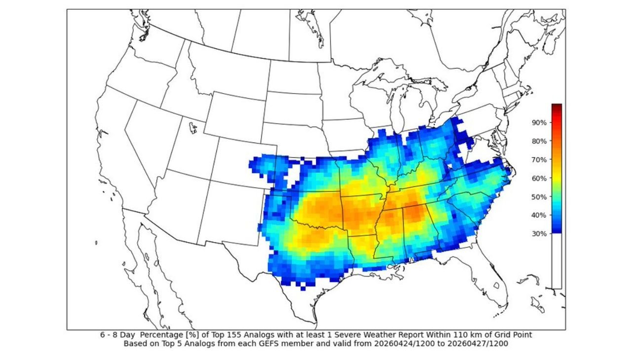
The probability maps shown in current analysis are built from ensemble analog data — a forecasting technique that identifies the top historical weather pattern matches from a large pool of past cases and calculates the percentage of those analogs that produced severe weather or tornadoes within a specific distance of each location. This approach gives forecasters a statistically grounded estimate of severe weather likelihood based on how similar past atmospheric setups actually performed.
Left Map — Severe Weather Probability (April 24 to 27, 2026): The severe weather probability map shows a significant and broad area of elevated risk centered over the southern Plains and mid-South corridor. The highest probabilities — shown in red and orange representing the top analog performance — are concentrated over Oklahoma, Kansas, Arkansas, Missouri, and Texas. A broad blue and cyan zone extends the elevated severe weather signal across Tennessee, Mississippi, Louisiana, and into Alabama and Georgia. This map is telling forecasters that the atmospheric pattern setting up this weekend closely resembles historical cases that produced widespread severe weather across the south-central United States.
Right Map — Tornado Probability (April 24 to 27, 2026): The tornado probability map shows a more focused but still significant signal. The highest tornado analog probabilities — shown in orange and yellow — are concentrated over Arkansas, Missouri, Oklahoma, and Tennessee. The broader blue zone extends tornado potential across Mississippi, Alabama, Louisiana, and into the Ohio Valley. For Arkansas specifically, seeing the state appear in the core of the tornado analog probability zone after 12 months of near-zero significant tornado activity is a notable and attention-grabbing signal.
Analog Probability Data Summary
| Zone | Severe Weather Signal | Tornado Signal | Key States |
|---|---|---|---|
| Highest Probability Core | Red and Orange | Orange and Yellow | Oklahoma, Arkansas, Missouri, Kansas |
| Elevated Probability | Cyan and Blue | Cyan and Blue | Tennessee, Mississippi, Louisiana, Alabama |
| Marginal Signal | Light Blue | Light Blue | Georgia, Ohio Valley, Texas Gulf Coast |
State-by-State Breakdown
Arkansas After 12 months of extremely slow severe weather activity, Arkansas sits inside both the high severe weather probability zone and the elevated tornado probability zone for the April 24 to 27 window. Little Rock, Fort Smith, Jonesboro, Fayetteville, and communities across the state should be weather-aware heading into the weekend. The analog data indicates this pattern closely resembles historical cases that produced organized storm activity across the state.
Oklahoma and Kansas Both states are positioned inside the highest probability core on the severe weather analog map. Oklahoma City, Tulsa, Wichita, and surrounding communities fall within the zone where the analog data shows the strongest historical severe weather signal for the upcoming pattern.
Missouri St. Louis, Kansas City, Springfield, and Missouri broadly fall inside the elevated severe weather and tornado probability zones. The mid-Missouri corridor has been an active target throughout April 2026 and the analog data suggests continued storm activity into the final week of the month.
Tennessee and Mississippi Nashville, Memphis, Jackson, and communities across Tennessee and Mississippi fall within the elevated severe weather and tornado probability zones on both maps. The mid-South corridor — which includes Arkansas, Tennessee, and Mississippi — is showing the most consistent signal for organized severe weather across the entire April 24 to 27 window.
Louisiana and Alabama New Orleans, Baton Rouge, Birmingham, and Mobile fall within the broader elevated probability zone. Severe weather is possible across the Gulf South states during this period, though the highest-confidence signals remain focused on the Arkansas and Oklahoma core.
Forecast Confidence
Confidence: Low to Moderate — and appropriately so for a multi-day severe weather outlook still several days away. The analog data is a probabilistic tool, not a deterministic forecast. What it is communicating is that the atmospheric pattern setting up this weekend is the type of pattern that historically produces significant severe weather across the southern United States — including Arkansas — in a meaningful percentage of similar past cases.
The transition from 12 months of quiet to a multi-day severe weather sequence is not guaranteed, but the data is consistent enough that residents across Arkansas, Oklahoma, Tennessee, Mississippi, and Missouri should be actively monitoring forecast updates through the remainder of this week as the system comes into clearer focus.
More severe weather pattern and tornado outlook coverage is always on the horizon. Stay informed at ChicagoMusicGuide.com — your source for southern severe weather tracking across Arkansas, Oklahoma, Tennessee, and the entire United States.