Western Washington Faces Rain, Breezy Winds and Near-Freezing Overnight Temperatures Through Tuesday as a Developing Low Pressure System Moves Inland This Morning
SEATTLE, WA — A developing storm system is already showing up on satellite imagery over western Washington this morning — and what it brings over the next 48 hours is a layered weather story that touches everything from rain and breezy winds today, to isolated thunderstorm potential this afternoon, to dropping snow levels tonight, to near-freezing overnight temperatures stretching from northern Oregon all the way through western Washington into Monday and Tuesday morning. For residents across the Puget Sound, the Cascade foothills and the coast, this is a system worth understanding from top to bottom before the day goes any further.
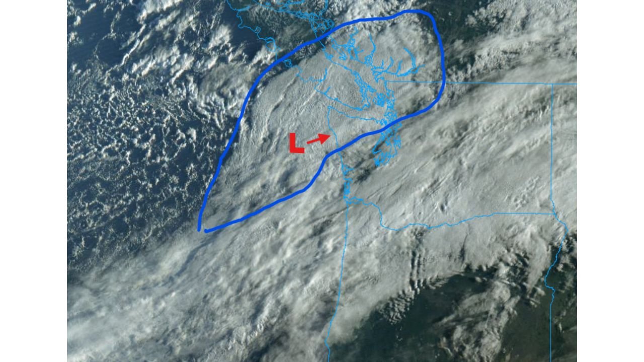
What the Satellite Is Showing Right Now
This morning’s satellite imagery is displaying what meteorologists call a baroclinic leaf — a specific cloud pattern that marks one of the earliest visible stages of a developing low-pressure system. The name comes from exactly what it looks like from space: a smooth, leaf-shaped area of clouds with a distinct outline, wrapping around a small but identifiable circulation center.
Think of a baroclinic leaf as the atmosphere’s first draft of a storm. The low pressure center is small and relatively weak at this stage, but it is real — currently developing along the Pacific Coast and moving inland over western Washington. The important thing to understand is that once a developing low moves inland, the terrain disrupts its circulation and typically halts further intensification. That is exactly what is happening here — and it is why this system is not expected to become a major storm despite its organized appearance on satellite.
The crisp, textured cloud field visible behind the main cloud mass in the satellite image is also significant. Those sharper-looking clouds are the signature of cold air convection — instability created when a cold airmass moves over a region. It is not a dramatic signal, but it is enough to keep an isolated thunderstorm on the table for this afternoon.
Today’s Timeline: What Happens and When
This morning: Rain is already pushing inland over western Washington with breezy winds possible for some coastal and lower-elevation areas as the system moves onshore. The low pressure center is tracking inland, which will gradually reduce wind threat as the day progresses.
This afternoon: Most of western Washington will begin drying out as the main precipitation shield moves through. However, isolated thunderstorms remain possible for any area that catches a brief sun break this afternoon. The cold airmass moving in behind the system creates just enough instability that a quick-hitting thunderstorm cannot be completely ruled out — particularly along the Cascade foothills where daytime heating can occasionally trigger convection even on otherwise unremarkable days.
Tonight through Monday morning: This is where the story gets more interesting for higher elevation areas. The cold air aloft moving in with this system will push snow levels significantly lower — dropping them enough that spotty snowflakes are possible tonight through Monday morning for areas at higher elevations and locations receiving heavier precipitation. This is not a significant snowstorm signal — it is a reminder that even late March in western Washington can deliver a dusting at elevation when cold systems push through.
Monday night through Tuesday morning: As skies clear behind the system, radiational cooling takes over. Radiational cooling is what happens on clear nights when the ground loses heat rapidly to the open sky without any cloud cover to trap warmth. The result across western Washington and into northern Oregon will be temperatures dipping close to or below freezing overnight Monday into Tuesday morning. This near-freezing threat is real enough to matter for sensitive vegetation, early spring gardens and anyone with frost-sensitive outdoor equipment.
Wednesday and beyond: Relief is coming. Temperatures will warm noticeably heading into Wednesday and the near-freezing overnight threat will ease. Areas west of the Cascades will largely be out of the woods when it comes to frost and freezing temperatures once Wednesday arrives.
Western Washington Weather Timeline Table
| Time Period | Primary Threat | Areas Most Impacted | Confidence |
|---|---|---|---|
| Today — Morning | Rain moving in, breezy winds | Western WA coast, Puget Sound | 🔴 High |
| Today — Afternoon | Isolated thunderstorm possible | Sun-break areas, Cascade foothills | 🟡 Low-Moderate |
| Tonight – Monday AM | Snow levels drop, spotty snowflakes | Higher elevations, heavier precip areas | 🟠 Moderate |
| Mon night – Tue AM | Near or below freezing overnight | Western WA, northern Oregon | 🔴 High |
| Wednesday onward | Warming trend, frost threat easing | West of Cascades | ✅ High |
Area-by-Area Breakdown
🔴 Western Washington Coast and Puget Sound — Seattle, Tacoma, Olympia — Rain and breezy conditions this morning as the system moves inland. Afternoon drying expected. Near-freezing overnight temperatures Monday night into Tuesday morning are the most significant threat for these highly populated areas.
🟠 Cascade Foothills and Higher Elevations — Best chance for isolated thunderstorm activity this afternoon if sun breaks occur. Snow level drops tonight through Monday morning make spotty snowflakes possible for communities at elevation. Areas under heavier precipitation bands have the best chance of seeing accumulating snow at the surface.
🟠 Northern Oregon — Portland metro and surrounding areas — The near-freezing overnight signal extends south from western Washington into northern Oregon Monday night through Tuesday morning. Frost protection for gardens and sensitive plants is advisable before Monday evening.
🟡 Eastern Washington — Spokane, Tri-Cities — The Cascades act as a barrier for much of this system’s moisture. Eastern Washington will see far less impact from the rain and wind side of this event though cold temperatures aloft are a regional feature.
🟢 Southern Oregon and California border — Outside the primary impact zone for this system. Minimal weather impact expected.
What to Watch For the Rest of Today
The most actionable information from this morning’s data comes down to three specific items for western Washington residents.
Rain and breezy winds are happening now across the coast and western lowlands — plan accordingly for any morning commute or outdoor activity. Keep a loose eye on the sky this afternoon — if your area gets a brief sun break, a quick-moving thunderstorm is a non-zero possibility, though it would be brief and isolated. And before Monday evening, take any frost-sensitive plants indoors or cover them — the radiational cooling signal for Monday night into Tuesday morning is confident enough to act on now rather than scrambling Sunday night.
Data Sources: Satellite Analysis — Baroclinic Leaf Feature, Western Washington, March 30, 2026 | NOAA/NWS Seattle Forecast Office | Pattern assessment current as of morning March 30, 2026
Western Washington Weather Moves Fast and This Week Is No Exception
More Pacific systems are always lined up offshore and ready to move onshore across Washington and Oregon. Stay informed at ChicagoMusicGuide.com — your source for Pacific Northwest weather analysis, storm system tracking and daily forecast updates across Washington, Oregon and the entire United States.