Kansas and Oklahoma Are Now Facing a Rapidly Escalating Severe Weather Threat on April 3 as the Latest Data Shows Nearly 3,000 Units of Storm Fuel Building Across the Central and Southern Plains
WICHITA, KS — The April 3rd severe weather signal just got significantly stronger. What was being watched as a potential significant severe weather day just days ago is now supported by explosive atmospheric fuel readings that are raising the stakes considerably for residents across Kansas and Oklahoma. The latest model data is now forecasting surface CAPE values approaching 3,000 J/kg across the central and southern Plains on April 3rd — a number that puts this setup firmly in the category of all-hazard severe weather days capable of producing tornadoes, baseball-sized hail and damaging winds across a wide area.
What CAPE Is and Why 3,000 J/kg Changes Everything
CAPE stands for Convective Available Potential Energy — and the easiest way to understand it is to think of it as the fuel tank for thunderstorms. The more CAPE in the atmosphere, the more energy is available for storms to tap into. The stronger that energy, the more explosive, tall and dangerous the thunderstorms that develop can become.
Here is a simple CAPE reference guide that puts the April 3rd numbers in perspective:
- Below 500 J/kg — Little to no thunderstorm potential
- 500 to 1,000 J/kg — Garden-variety thunderstorm environment
- 1,000 to 2,000 J/kg — Moderate severe weather potential
- 2,000 to 3,000 J/kg — Significant severe weather environment
- Above 3,000 J/kg — Explosive severe weather potential, major outbreak capable
The latest GFS model data, valid for April 3, 2026, is placing surface CAPE values near 3,000 J/kg across the heart of Kansas and Oklahoma. That puts this setup at the upper end of the significant severe weather range — and approaching the threshold where major, long-track tornadoes and widespread hail events become legitimate possibilities.
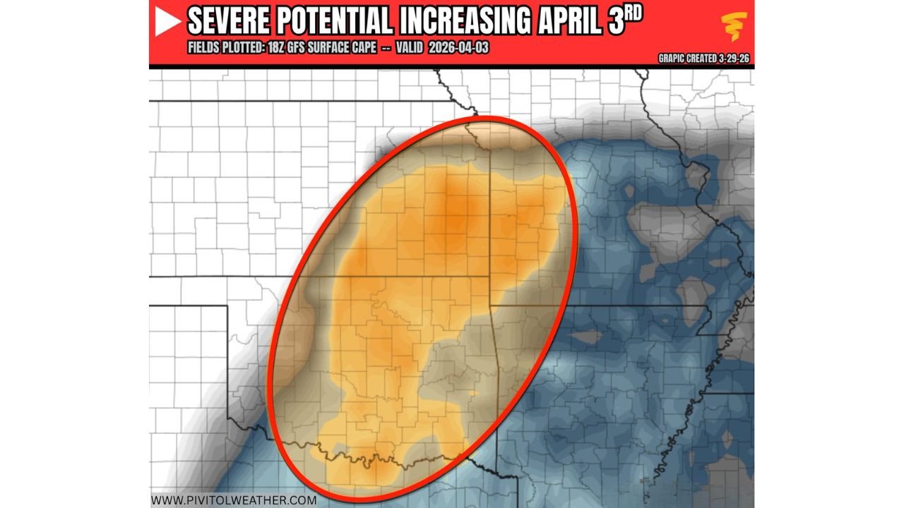
What the CAPE Map Is Showing for April 3rd
The GFS Surface CAPE map, plotted March 29, 2026, valid April 3, 2026, shows the instability footprint across the central United States in striking detail. The orange and amber shading across the map represents the zones of highest CAPE — the areas where the atmospheric fuel tank is most loaded.
The red oval on the map identifies the primary area of concern — a broad zone covering central and western Kansas, all of Oklahoma and extending into portions of southern Nebraska and northern Texas. This is where the CAPE values are highest and where the overlap between instability, moisture return and the incoming trough creates the most favorable severe weather environment on April 3rd.
The deep orange core within that oval — centered over central Kansas and north-central Oklahoma — is where the model is placing the most intense instability values approaching and potentially exceeding 2,500 to 3,000 J/kg. This is the zone that warrants the closest attention between now and Friday.
To the east, blue shading across Missouri, Iowa and Illinois represents negative surface CAPE — areas where the atmosphere is actually stable at the surface and would need significant forcing to overcome that stability for storm development. This contrast between the explosive western instability and the stable eastern boundary is actually a positive signal for organized, discrete supercell development — the type of storm most likely to produce significant tornadoes.
What Makes This Setup Different From a Routine Severe Weather Day
Three ingredients are now converging for April 3rd in a way that separates this from an ordinary storm day across the Plains.
First — the fuel is there. Near-3,000 J/kg of surface CAPE across Kansas and Oklahoma is not a background threat. It is an explosive environment that will power any storm that manages to initiate into something significant very quickly.
Second — the trigger is arriving. A trough ejecting into the Plains from the west is the atmospheric mechanism that will lift the warm, moist and unstable surface air upward on April 3rd. Growing model agreement on this shortwave arrival is increasing confidence that storm initiation will actually occur rather than being capped out by the atmosphere.
Third — the moisture is returning. Gulf moisture streaming northward into the Plains ahead of the approaching system is what is building those CAPE values in the first place. Returning Gulf moisture overlapping with the incoming trough is the textbook recipe for a central Plains severe weather outbreak.
April 3rd Severe Weather Threat Assessment Table
| Parameter | Current Value | Threshold for Major Outbreak | Status |
|---|---|---|---|
| Surface CAPE | Near 3,000 J/kg | 2,500+ J/kg | 🔴 Approaching Explosive |
| Moisture Return | Gulf moisture streaming north | Deep moisture layer needed | 🔴 Favorable |
| Trough Trigger | Growing model agreement | Shortwave ejection needed | 🟠 Moderate-High Confidence |
| All Hazards | Tornadoes, hail, wind | All three in play | 🔴 Confirmed |
| SPC Highlighted Risk | Expected as models converge | Model agreement needed | 🟠 Anticipated Soon |
| Overall Confidence | Significantly elevated | — | 🟠 Moderate and Rising |
Where Each State Stands Right Now
🔴 Kansas — Wichita, Salina, Dodge City, Liberal corridor — Sitting inside the highest CAPE zone on the entire map. Central and western Kansas faces the most explosive instability values of any area in the risk corridor. All three severe weather hazards are in play — and with CAPE values approaching 3,000 J/kg, the storm environment here on April 3rd is capable of supporting significant, long-track tornadoes if wind shear aligns as expected.
🔴 Oklahoma — Oklahoma City, Enid, Lawton, Ponca City — The southern half of the red oval covers all of Oklahoma north of the Red River. North-central Oklahoma sits directly in the CAPE bullseye alongside central Kansas. Tornado-capable supercells are the primary concern for the Oklahoma City metro and the surrounding I-35 corridor.
🟠 Nebraska — Southern tier, North Platte through Lincoln — The northern edge of the orange CAPE zone clips southern Nebraska. Large hail is the primary threat for Nebraska on April 3rd, with tornado potential secondary depending on the exact trough placement and storm initiation point.
🟠 Northern Texas — Amarillo through the Panhandle — The southern extension of the CAPE zone reaches into the Texas Panhandle. Storm development is possible here as well, particularly if surface boundaries set up across the region earlier in the day.
🟡 Missouri and Iowa — The blue stable zone on the map covers most of Missouri and Iowa at the surface. Severe weather is possible here later in the evening if storms from Kansas and Oklahoma track northeast — but the primary severe weather window for these states is secondary to the Kansas-Oklahoma core.
What the Storm Prediction Center Is Expected to Do
Based on the current data trajectory, a highlighted risk area from the Storm Prediction Center is anticipated as model agreement increases over the next 24 to 48 hours. The combination of near-3,000 J/kg CAPE values, a favorable trough trigger and returning Gulf moisture is exactly the kind of signal that earns elevated categorical risk designations on the SPC outlook.
Residents across Kansas and Oklahoma should be monitoring the SPC Day 4 and Day 5 outlooks closely between now and Thursday as those products sharpen into the higher-resolution Day 1 and Day 2 range heading into Friday.
What to Do Between Now and Friday Morning
April 3rd is four days away. That is enough preparation time — but only if you use it. The single most important action right now for anyone in Kansas, Oklahoma or the southern Nebraska corridor is to make sure your wireless emergency alerts are enabled on every device in your household. Tornado warnings in a near-3,000 CAPE environment can follow watches very quickly — sometimes within minutes of a watch being issued.
Know your shelter plan. Know the difference between a Tornado Watch — the atmosphere is loaded and capable, stay alert — and a Tornado Warning — a tornado is occurring or imminent, take shelter immediately. In a high-CAPE environment, the time between watch and warning can be very short and storms can intensify rapidly.
Check back daily as the April 3rd window comes into high-resolution model range. The forecast will tighten considerably with each passing day.
April 3rd Could Be One of the Most Significant Severe Weather Days of the Spring Season Across Kansas and Oklahoma
The fuel is loading. The trigger is arriving. The time to prepare is right now. Stay informed at ChicagoMusicGuide.com — your source for daily CAPE analysis, severe weather outbreak tracking and tornado coverage across Kansas, Oklahoma, Nebraska and the entire United States.