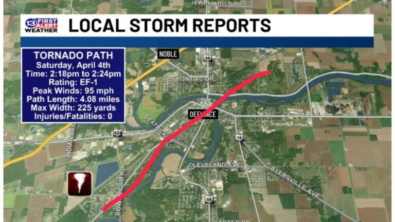
Oklahoma and Kansas Face Their Highest Tornado Probability Wednesday While Chicago and Illinois Take the Lead Thursday as a Multi-Day Severe Weather Outbreak Builds Across the Central United States April 1 and 2
OKLAHOMA CITY, OK — Friday April 3rd has been getting all the attention — but the latest probability data is now telling a different story. Wednesday April 1st and Thursday April 2nd are both showing higher tornado probabilities than Friday across specific areas of the central United States. Two separate and distinct tornado threat bullseyes have now emerged in the data — one centered directly over Oklahoma City and the surrounding corridor on Wednesday, and a second one locked onto Chicago and the northern Illinois region on Thursday. This is a multi-day severe weather outbreak in the making, and it is shaping up faster than most forecasters anticipated just 24 hours ago.
Wednesday April 1: Oklahoma and Kansas Are the Bullseye
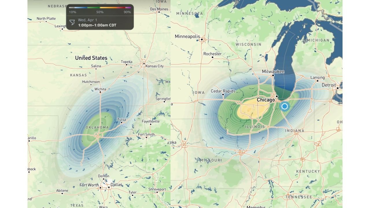
The Wednesday April 1st tornado probability map, valid from 1:00 PM to 1:00 AM CDT, shows a concentrated bullseye of tornado probability centered over central Oklahoma — directly over Oklahoma City, Norman and the surrounding metro area — with the risk extending northward through Tulsa, Wichita and into south-central Kansas.
The probability contours on this map are tightly packed and clearly organized — a signal that the data has high confidence in the geographic placement of the Wednesday threat. The bullseye is not diffuse or spread across hundreds of miles. It is focused and centered, which is exactly the kind of signal that indicates a well-organized severe weather setup rather than a broad, uncertain pattern.
The Wednesday tornado window runs from 1:00 PM through 1:00 AM CDT — a full 12-hour severe weather period that covers both the afternoon peak instability hours and the dangerous overnight window when most people are asleep and warning reception is reduced.
Key cities inside the Wednesday bullseye include Oklahoma City, Norman, Tulsa, Wichita, Hutchinson and Salina. The Kansas City metro sits on the northeastern fringe of the risk area, and communities across northwest Arkansas and Fort Smith are on the southeastern edge of the probability zone.
Just 24 hours ago, there was zero model support for a Wednesday severe weather setup of this magnitude. The fact that probability data has now emerged showing a concentrated Oklahoma-Kansas tornado bullseye is a significant forecast development that demands immediate attention from anyone in this corridor.
Thursday April 2: Chicago and Illinois Step Into the Crosshairs
While Oklahoma and Kansas manage Wednesday’s threat, the tornado probability data shifts dramatically northeast by Thursday — placing a new bullseye directly over Chicago and the northern Illinois corridor.
The Thursday tornado probability map shows the highest probability contours centered over Chicago, Rockford and the northern Illinois region, with the risk extending east into Indiana and west toward Cedar Rapids and Iowa. The yellow probability zone — the highest-confidence area on the map — is sitting almost directly on top of one of the most densely populated metros in the entire United States.
This is a notably unusual signal for early April. While Illinois and the Chicago area are no strangers to severe weather, a concentrated tornado probability bullseye centered directly over the Chicago metro is a forecast that affects millions of people across the I-90 and I-94 corridors, the city’s neighborhoods, and the surrounding suburbs from Naperville to Waukegan.
Cedar Rapids and eastern Iowa are also inside the elevated probability zone on Thursday, as the risk extends westward from the Chicago core. Milwaukee and southern Wisconsin sit on the northern edge of the threat area, with Indianapolis and northern Indiana on the southeastern fringe.
Why Wednesday and Thursday Are Now the Priority Days
Here is the critical piece of information that changed in the last 24 hours. Wednesday and Thursday are now carrying higher tornado probabilities than Friday April 3rd for their respective target areas. Friday has been the headliner all week — but the latest data is saying the most focused, highest-probability tornado threat of this entire multi-day outbreak belongs to Oklahoma on Wednesday and Chicago on Thursday.
This does not mean Friday is off the table — the April 3rd setup across Kansas and Oklahoma remains a significant concern with near-3,000 CAPE values already being modeled. But the tornado probability data is now drawing a clear picture that the outbreak begins Wednesday afternoon and runs through the better part of three consecutive days.
Multi-Day Tornado Outbreak Probability Table
| Day | Primary Bullseye | Peak Window | Key Cities at Risk | Confidence |
|---|---|---|---|---|
| Wednesday April 1 | Central Oklahoma, S. Kansas | 1 PM – 1 AM CDT | OKC, Tulsa, Wichita | 🔴 Moderate-High |
| Thursday April 2 | Chicago, N. Illinois | Afternoon-Evening | Chicago, Rockford, Cedar Rapids | 🔴 Moderate-High |
| Friday April 3 | Central Kansas, N. Oklahoma | Afternoon-Evening | Wichita, OKC, Dodge City | 🟠 Moderate |
| Overall Outbreak | Three consecutive days | Wed PM – Fri PM | Multi-state corridor | 🟠 Moderate-High |
Where Each State Stands Across the Three-Day Window
🔴 Oklahoma — Oklahoma City, Tulsa, Norman, Lawton — Wednesday is Oklahoma’s day. The tornado probability bullseye is centered directly over the OKC metro for the 1 PM to 1 AM CDT window. This is the highest-priority severe weather situation for Oklahoma residents in the entire three-day stretch. Wednesday afternoon and evening demand full situational awareness across the state.
🔴 Kansas — Wichita, Salina, Hutchinson, Topeka — Inside the Wednesday bullseye and returning as a risk area on Friday. South-central Kansas sits in the overlap zone between the Wednesday Oklahoma threat and the Friday Plains setup — making Kansas one of the most consistently at-risk states across the entire outbreak window.
🔴 Illinois — Chicago, Rockford, Springfield, Peoria — Thursday is Illinois’s day. The tornado probability bullseye parks directly over northern Illinois and the Chicago metro on Thursday. For the millions of people across Cook County, DuPage County, Lake County and the surrounding collar counties — Thursday afternoon and evening is the window that demands full preparation and situational awareness.
🟠 Iowa — Cedar Rapids, Des Moines — Inside the Thursday probability zone. Cedar Rapids sits in the elevated tornado probability area on Thursday. This is not a marginal threat for eastern Iowa — the data is placing meaningful tornado probability over this region.
🟠 Indiana — Indianapolis, South Bend, Fort Wayne — On the eastern fringe of the Thursday Chicago bullseye. Indianapolis and northern Indiana face tornado potential Thursday as storms track northeast out of Illinois.
🟠 Arkansas — Fort Smith, Fayetteville — On the southeastern edge of the Wednesday Oklahoma threat. Tornado potential exists for northwest Arkansas communities during the Wednesday afternoon and evening window.
🟠 Missouri — Springfield, Kansas City — Kansas City sits on the northeastern fringe of the Wednesday risk zone. Springfield is in the broader marginal zone. Both cities should monitor the Wednesday timeline closely.
🟢 Texas — North Texas corridor — On the southern fringe of the Wednesday Oklahoma setup. Fort Worth and Dallas sit below the primary probability contours but remain weather aware for the Wednesday afternoon window.
The Most Important Thing You Can Do Right Now
If you are in Oklahoma or Kansas — your preparation window for Wednesday closes tomorrow. The 1 PM CDT start time on Wednesday means severe weather could be initiated and moving by early afternoon. Do not wait until Wednesday morning to review your severe weather plan, confirm your shelter location and activate your phone alerts.
If you are in Chicago or northern Illinois — Thursday is your day to prepare for today. A tornado probability bullseye over one of the most densely populated cities in the country is a forecast that affects apartment dwellers, commuters, school schedules and event planning across the entire metro. Interior rooms on the lowest floor of your building are your shelter during a tornado warning — know exactly where that is before Thursday arrives.
For both events, the difference between a Tornado Watch and a Tornado Warning is the difference between staying alert and taking immediate shelter. A Tornado Warning means now. Get to shelter the moment one is issued for your county — do not wait to see the storm.
Three Days of Tornado Potential Are Now on the Table Across Oklahoma, Kansas, Illinois and Iowa
The outbreak window opens Wednesday and runs through Friday. Stay informed at ChicagoMusicGuide.com — your source for daily tornado probability updates, outbreak tracking and severe weather coverage across Oklahoma, Kansas, Illinois, Iowa and the entire United States.