Friday April 3 Brings Scattered Severe Weather Across Kansas, Oklahoma and Missouri as an Elongated Low Pressure System Sets Up From the Texas Panhandle to Omaha With Damaging Winds, Hail and a Tornado Risk All on the Table
WICHITA, KS — Friday April 3rd is now close enough that the atmospheric picture is starting to come into clearer focus — and what it is showing for the Kansas, Oklahoma and Missouri corridor is a scattered severe weather day with multiple threats. An elongated low pressure system stretching from the Texas Panhandle all the way north to near the Missouri River and Omaha will be the driving force behind Friday’s storms, pulling warm and humid Gulf air northward ahead of it while a cold front pushes east through the afternoon. The result will be a mix of supercells and storm clusters capable of producing damaging wind gusts, large hail and a tornado risk — with the details of where the tornado threat is highest still being finalized as the event approaches.
How Friday’s Setup Works: The Big Picture
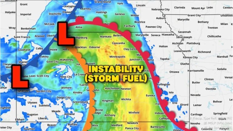
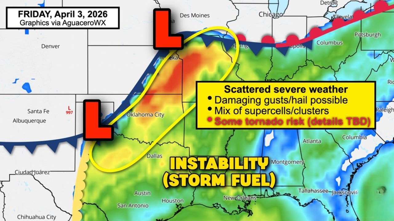
Two surface low pressure centers are visible on Friday’s atmospheric map — one positioned near Oklahoma City at approximately 997 mb and a second, larger low tracking from Kansas into the Omaha corridor to the north. Together, these two low pressure systems create an elongated trough that extends from the Texas Panhandle northward through western Kansas and into Nebraska near the Missouri River.
This elongated low pressure setup is significant because it creates a long, north-south oriented severe weather corridor rather than a compact, focused target area. The cold front extending from the northern low southwestward through Oklahoma and into Texas is the primary storm trigger for Friday — as that front pushes east through the afternoon and encounters the warm, moist Gulf air being pulled northward ahead of the low, storm initiation begins.
The instability zone — labeled directly on the map as the “storm fuel” — is shown in the yellow and red shading covering Oklahoma, Kansas, Missouri and into the Arkansas and Tennessee border region. This is the warm sector where Gulf moisture and atmospheric instability are highest, and where the most explosive storm development will occur as the cold front and dryline interact with that energy through Friday afternoon.
What the Jet Stream Adds to This Setup
The jet stream is the ingredient that separates a routine severe weather day from a day with significant tornado potential — and Friday’s setup has jet stream dynamics working in the right direction.
The jet stream is the fast-moving river of air roughly 6 to 8 miles above the surface that steers storm systems and provides the upper-level wind support that organizes thunderstorms into long-lived, rotating supercells. On Friday, jet stream dynamics are expected to be favorable for supporting the stronger storms that develop along and ahead of the cold front. That upper-level support combined with the strong wind shear generated by the low pressure system at the surface creates the full-column atmospheric configuration that allows supercell thunderstorms to develop and sustain rotation.
A tornado risk may materialize specifically in the areas where the jet stream support, surface low wind shear and instability all overlap most favorably. The exact location of that tornado risk zone is still being determined — the Wednesday and Thursday convective evolution across the region will significantly influence exactly where Friday’s most favorable severe weather area sets up.
What Wednesday and Thursday Have to Do With Friday
Here is a connection that most weather coverage misses — and it is critical for understanding why Friday’s forecast still carries considerable uncertainty even as the pattern comes into focus.
How Wednesday night’s squall line and Thursday’s storm activity evolve across the region will directly impact Friday’s setup. Specifically, the number and placement of outflow boundaries left behind by Wednesday and Thursday storms will determine where Friday’s discrete supercells are most likely to initiate and where they will find the most favorable environment for tornado production.
An outflow boundary from Wednesday night’s Oklahoma squall line, for example, could set up as an invisible but powerful storm trigger that fires isolated supercells Friday afternoon in a location that is not currently being highlighted as a high-risk zone. Conversely, if Wednesday and Thursday storms are less organized than expected, the boundary environment on Friday may be cleaner and more supportive of long-track supercells across the traditional Tornado Alley corridor.
This Wednesday-Thursday-Friday dependence is the primary source of uncertainty in the Friday forecast — and it is why last-minute adjustments to the Friday risk area are expected as the week progresses.
Friday April 3 Severe Weather Setup Table
| Parameter | Current Signal | Confidence | Key Uncertainty |
|---|---|---|---|
| Elongated Surface Low | Texas Panhandle to Omaha | 🔴 High | Exact low track |
| Warm Sector Instability | KS, OK, MO corridor | 🔴 High | Coverage and depth |
| Cold Front Trigger | Pushing east through afternoon | 🔴 High | Exact timing |
| Jet Stream Support | Favorable upper dynamics | 🟠 Moderate-High | Exact placement |
| Storm Mode | Mix of supercells and clusters | 🟠 Moderate | Wed/Thu evolution dependent |
| Tornado Risk | Present — details TBD | 🟠 Moderate | Boundary placement critical |
| Overall Confidence | Scattered severe confirmed | 🟠 Moderate | Details sharpening |
State-by-State Impact for Friday
🔴 Kansas — Wichita, Topeka, Dodge City, Liberal — Sitting directly inside the elongated low pressure trough and instability zone for Friday. The warm sector covering central and western Kansas provides the storm fuel, while the cold front trigger and jet stream dynamics overhead create the organizing mechanism for supercell development. Kansas remains the highest-priority state for Friday’s tornado risk.
🔴 Oklahoma — Oklahoma City, Tulsa, Enid — The 997 mb surface low near OKC places Oklahoma squarely inside the most intense surface pressure gradient on the Friday map. Strong surface winds converging near the low create excellent low-level wind shear — the critical ingredient for tornado-producing supercells. Friday afternoon through evening is Oklahoma’s primary window.
🟠 Missouri — Kansas City, St. Louis, Springfield — The northern surface low tracks through the Kansas City corridor on Friday, placing Missouri inside the risk zone particularly for the Kansas City metro and western Missouri communities. Damaging winds are the highest-confidence threat for Missouri, with hail and tornado potential depending on storm mode.
🟠 Nebraska — Omaha, Lincoln — The northern end of the elongated low tracks near the Missouri River and Omaha on Friday. Omaha and southeast Nebraska face severe weather potential, particularly from any squall line or storm cluster that develops to the southwest and tracks northeast through the corridor.
🟠 Iowa — Des Moines, Council Bluffs — On the northeastern edge of Friday’s risk area. Storm activity from Kansas and Missouri tracking northeast will reach southern Iowa during Friday afternoon and evening. Damaging winds and hail are the primary threats.
🟡 Texas — Amarillo, Texas Panhandle — Southern end of the elongated low. Isolated severe weather possible across the Panhandle but the primary risk is concentrated in the Kansas-Oklahoma core.
The Bottom Line for Friday Right Now
Scattered severe weather across Kansas, Oklahoma and Missouri on Friday April 3rd is confirmed. The broad outline of this event is clear — damaging winds, large hail and a tornado risk are all on the table. What is not yet locked in are the precise locations of the highest tornado risk and the exact storm mode evolution.
Friday morning will be the most critical forecast update of the week for this event. By then, the Wednesday night and Thursday storm activity will have already played out — and forecasters will know exactly what kind of boundary environment Friday’s storms will be developing into. The SPC’s Day 1 outlook issued Friday morning will be the definitive guide for where to focus the greatest concern.
If you are in Wichita, Oklahoma City or Kansas City — review your severe weather plan today. Do not wait until Friday morning. Know your shelter. Have your alerts active. And check back Friday morning before you leave the house.
Friday’s Severe Weather Setup Is Confirmed and the Details Are Coming Into Focus Fast
Wednesday, Thursday and Friday are all active — and each day’s forecast is sharpening quickly. Stay informed at ChicagoMusicGuide.com — your source for daily severe weather updates, surface low tracking and storm corridor analysis across Kansas, Oklahoma, Missouri and the entire United States.