Chicago, Detroit and Cleveland Face a Slight Risk of Severe Weather Today March 31 as Supercells Fire This Afternoon Before Transitioning Into a Damaging Wind Threat Across the Midwest and Great Lakes
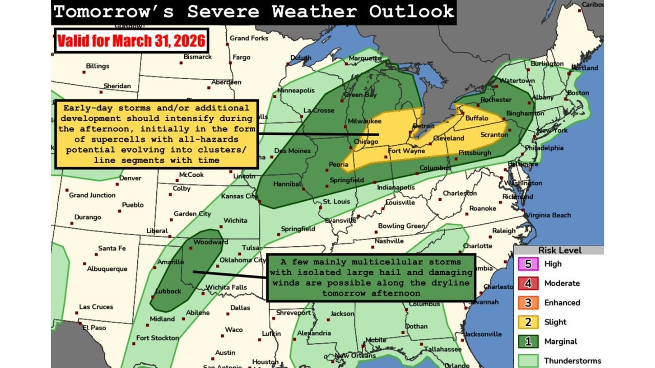
CHICAGO, IL — Today is a severe weather day across the Midwest and Great Lakes region — and the Storm Prediction Center has made it official. A Slight Risk of severe weather, rated Level 2 out of 5, is in effect for Tuesday March 31, 2026 across a broad corridor covering Chicago, Detroit, Fort Wayne, Cleveland, Columbus and the surrounding communities. Storms are expected to develop this afternoon in the form of supercells — rotating thunderstorms capable of producing all severe weather hazards — before gradually evolving into clusters and squall line segments by this evening. Large hail and damaging winds are the headline threats today, with a low but real tornado risk also present throughout the afternoon window.
How Today’s Storms Will Evolve: The Full Timeline
Understanding how today’s severe weather unfolds in phases is critical — because the threat profile changes significantly from the afternoon into the evening hours.
Early afternoon — Supercell development begins
The first storms of the day are expected to initiate during the early afternoon hours across the central and southern portions of the risk zone. These initial storms are forecast to develop in the form of supercells — the organized, rotating thunderstorms that are the most efficient producers of large hail and tornadoes. During this early supercell phase, large hail is the primary concern with any storm that develops. Hailstones in the 1-inch or larger range are possible with the stronger cells during the afternoon hours, and some hail could be significantly larger than that depending on the exact storm intensity.
The tornado risk is also present during this supercell phase — though it is characterized as low but nonzero. A low tornado risk from the SPC does not mean tornadoes will not happen. It means the atmospheric setup today is not optimized for widespread, long-track tornadoes — but individual supercells that maintain discrete rotation during the afternoon could produce brief tornadoes before the storm mode evolves.
Late afternoon into evening — Storms cluster and line out
By later in the afternoon and into the evening hours, the initial supercell storms are expected to merge and organize into clusters or squall line segments. This transition fundamentally changes the primary threat. As storms lose their discrete, organized rotation and become part of a larger line or cluster, the large hail threat decreases and the damaging straight-line wind threat becomes dominant.
Squall lines moving through the Chicago metro, Detroit and the surrounding Great Lakes communities during the evening hours will be capable of producing wind gusts of 60 mph or higher across a wide area simultaneously. This wind threat is the one that will impact the greatest number of people today — and it is the threat that will be most active during the Tuesday evening commute and early nighttime hours.
The Secondary Threat: Oklahoma and West Texas Dryline
While the Midwest and Great Lakes represent the primary SPC risk zone for today, a secondary severe weather area exists across the western Oklahoma and west Texas vicinity along an afternoon dryline.
A dryline is the sharp boundary between moist air from the Gulf of Mexico to the east and dry air pushing in from the west — and it is one of the most reliable storm triggers in the southern Plains during spring. Along this boundary today, isolated multicellular storms are possible during the afternoon with a low-end hail and wind risk. This is not a significant severe weather threat compared to the Midwest Slight Risk — but residents from Woodward and Tulsa through Oklahoma City and into Wichita Falls and Amarillo should be aware that some storm activity is possible this afternoon.
Today’s Severe Weather Outlook Table
| Risk Zone | Cities | Risk Level | Primary Threats | Timing |
|---|---|---|---|---|
| Slight Risk — Yellow | Chicago, Detroit, Fort Wayne, Cleveland | 🟡 Level 2/5 | Large hail, damaging winds, low tornado | Afternoon into evening |
| Marginal Risk — Green | Milwaukee, Indianapolis, Columbus, Pittsburgh | 🟢 Level 1/5 | Damaging winds, isolated hail | Afternoon into evening |
| Thunderstorm Risk — Lt. Green | St. Louis, Nashville, Louisville | ⛈️ General storms | Non-severe thunder possible | Afternoon |
| Dryline — Oklahoma/W. Texas | OKC, Tulsa, Wichita Falls, Amarillo | 🟢 Marginal | Isolated hail and wind | Afternoon only |
City-by-City Breakdown for Today
🟡 Chicago, IL — Inside the Slight Risk yellow zone. The Chicago metro faces the full severe weather threat timeline today — supercell hail threat this afternoon transitioning to squall line damaging winds by this evening. The I-90 and I-94 corridors will be active during the evening commute window. Weather alerts should be active and monitored from noon onward.
🟡 Detroit, MI — Directly inside the Slight Risk zone. Detroit, Dearborn and the Metro Detroit area face large hail with afternoon supercells and damaging winds as storms line out by evening. The Lake Erie and Lake Huron shoreline communities may see enhanced wind gusts as the squall line moves through.
🟡 Fort Wayne, IN — One of the most directly exposed cities in today’s Slight Risk zone. Fort Wayne sits near the center of the yellow risk area — facing supercell hail threat this afternoon and squall line winds by evening.
🟡 Cleveland and Akron, OH — On the eastern edge of the Slight Risk zone. Storms tracking northeast out of Indiana will reach the Cleveland metro by late afternoon or early evening. Damaging winds are the primary threat as storms arrive in an increasingly linear mode.
🟢 Milwaukee, WI — Inside the Marginal Risk zone. Severe weather is possible but less organized than the core Slight Risk area. Damaging wind gusts are the primary concern if squall line segments push through the Milwaukee metro this evening.
🟢 Indianapolis, IN — Marginal Risk zone. Storms are possible across Indianapolis during the afternoon but the highest-confidence Slight Risk area sits north and east of the city. Stay weather aware through the afternoon hours.
🟢 Columbus, OH — On the southeastern edge of the Marginal Risk zone. General storm activity is possible with isolated severe weather potential through the afternoon and evening.
🟢 Pittsburgh, PA — Eastern fringe of today’s risk area. Storms tracking northeast could reach western Pennsylvania by Tuesday evening with damaging wind potential.
What to Do Right Now
If you are in Chicago, Detroit or Fort Wayne — the afternoon severe weather window opens within hours. Here is what matters most before noon today.
Secure anything outdoors that could become a projectile in 60+ mph wind gusts — patio furniture, planters, lightweight equipment. Tuesday afternoon is not the time to leave items unsecured outside across the Midwest.
Keep weather alerts active on your phone throughout the afternoon and evening. Today’s storm evolution — from supercells to squall line — happens faster than many people expect. The window between a Severe Thunderstorm Watch being issued and the first Severe Thunderstorm Warning dropping for your specific county can be as short as 30 to 60 minutes.
For the evening commute — if you are driving home between 5 PM and 8 PM across northern Illinois, northern Indiana or southern Michigan, check radar before you leave. Squall line timing could put the most intense wind threat directly over major highway corridors during peak commute hours.
Today Is Just the First Day of a Multi-Day Severe Weather Outbreak Across the Central United States That Runs Through Saturday
Wednesday, Thursday, Friday and Saturday all carry severe weather potential for different parts of the country. Stay informed at ChicagoMusicGuide.com — your source for daily severe weather risk updates, SPC outlook tracking and storm coverage across Chicago, Detroit, Cleveland and the entire United States.