Texas, Oklahoma, Arkansas and Louisiana Face High Flood Risk as Heavy Rain Threat Expands Toward Midwest and Great Lakes April 11 Through April 17
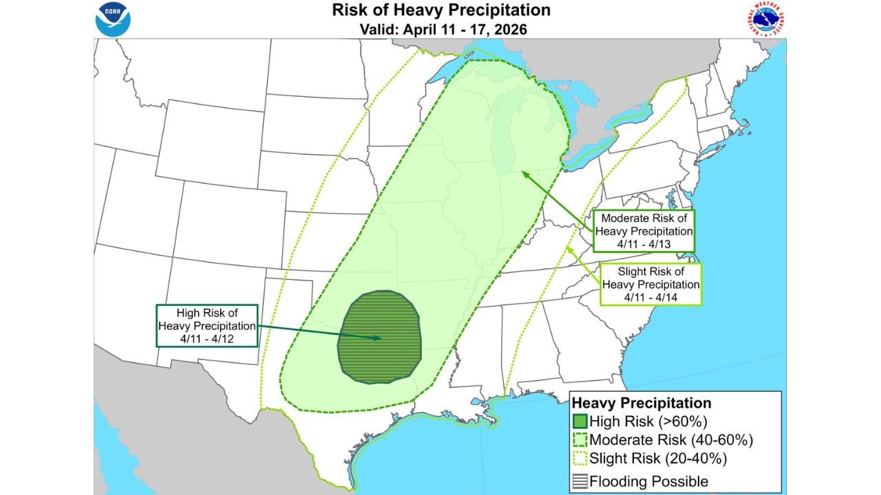
UNITED STATES — A significant heavy precipitation threat is developing across the central United States between April 11 and April 17, with the highest risk centered over parts of Texas, Oklahoma, Arkansas, and northwest Louisiana. Forecast data indicates that intense rainfall could lead to flash flooding and rising river levels, especially in areas that have already seen recent precipitation.
High Risk Zone Focused on Texas, Oklahoma, Arkansas and Louisiana
The most concerning area for heavy rainfall and potential flooding is concentrated across north Texas, southern Oklahoma, western Arkansas, and northwest Louisiana, where a high-risk zone (greater than 60%) has been identified for April 11–12.
This region is expected to experience repeated rounds of heavy rain, which significantly increases the likelihood of flash flooding, particularly in low-lying and flood-prone areas. Cities and communities within this zone should be prepared for rapid water accumulation, road flooding, and localized impacts.
The setup suggests a slow-moving system or repeated storm development, allowing rainfall totals to build quickly over a short period, which is a key factor in flood events.
Moderate and Slight Risk Extends Toward the Midwest and Great Lakes
Beyond the high-risk core, a broader moderate risk area (40–60%) stretches from the Southern Plains through the Mississippi Valley into the Midwest and parts of the Great Lakes, including states like Missouri, Illinois, Indiana, and Michigan.
Additionally, a slight risk zone (20–40%) extends even farther east into portions of the Ohio Valley and Mid-Atlantic, indicating a wider region that could still experience periods of heavy rain and localized flooding concerns.
This large coverage area highlights the expansive nature of the storm system, with moisture transport and atmospheric dynamics supporting rainfall across multiple regions simultaneously.
Flooding Concerns Elevated Due to Recent Rainfall
One of the key concerns with this upcoming system is that many of the affected regions have already experienced recent precipitation, leaving soils more saturated than usual.
When additional heavy rain falls on already wet ground, the risk of flash flooding increases dramatically, as water is less able to absorb into the soil. This leads to faster runoff into rivers, streams, and urban drainage systems, raising the threat of both flash floods and river flooding.
Areas along major river systems in the Mississippi Valley and Southern Plains will need to closely monitor water levels, as prolonged rainfall could lead to extended flooding concerns beyond the initial storm period.
Timing and What to Expect Through Mid-April
The primary window for this heavy rain and flooding threat begins around April 11, with the most intense rainfall expected during the early part of the period (April 11–12) in the southern regions.
As the system progresses, the focus of rainfall is likely to shift northeastward, bringing continued precipitation into the Midwest and Great Lakes between April 13 and April 17.
Residents across all affected regions should stay alert for flash flood watches, warnings, and rapidly changing conditions, especially during periods of intense rainfall.
This evolving pattern suggests a multi-day rain event rather than a single storm, increasing the cumulative impact across a wide portion of the country.
For continuous updates on major weather developments, regional alerts, and in-depth coverage of impactful weather patterns, visit ChicagoMusicGuide.com.