Oklahoma City, Shawnee and Little Confirmed in Friday Night Tornado Surveys as EF-1 and EF-0 Storm Damage Reports Continue Across Metro
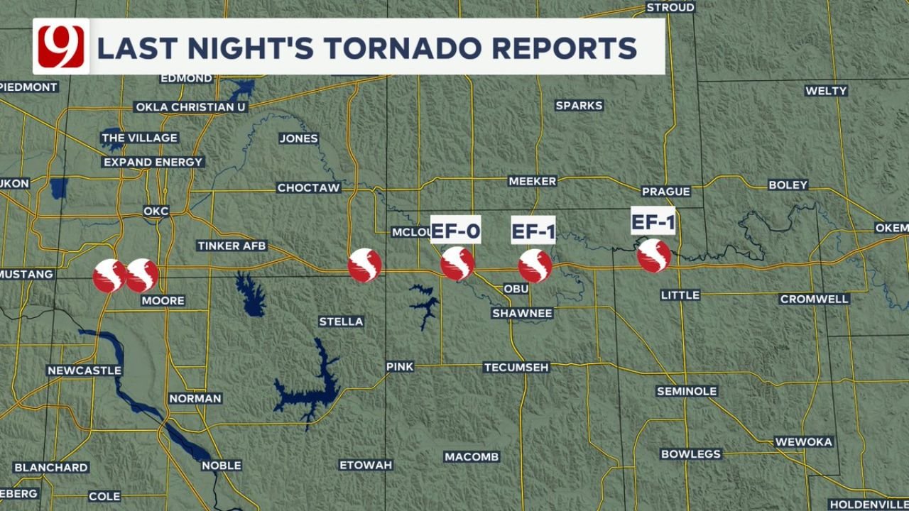
OKLAHOMA CITY, OKLAHOMA — Friday night’s severe weather outbreak across central and eastern Oklahoma is now being officially confirmed through storm surveys, with at least three tornadoes verified so far, including EF-1 damage in Shawnee and Little and an EF-0 tornado near Dale, as assessment teams continue reviewing additional damage across the metro.
Initial findings show that while the outbreak was not widespread in terms of high-end intensity, it still produced multiple confirmed tornado touchdowns, reinforcing the volatile storm setup that moved through the region overnight.
Confirmed Tornadoes Across Shawnee, Little and Dale
Survey teams have confirmed the following tornadoes from Friday night’s storms:
- EF-1 tornado in Shawnee
- EF-1 tornado in Little (near Prague area)
- EF-0 tornado in Dale
These ratings indicate wind speeds ranging from approximately 65 mph (EF-0) up to around 110 mph (EF-1), capable of causing roof damage, snapped tree limbs, and localized structural impacts.
The strongest confirmed impacts so far have been in and around Shawnee and Little, where EF-1 level damage suggests more organized storm rotation and stronger wind fields within the thunderstorms.
Oklahoma City Metro Also Impacted by Tornado Activity
The broader Oklahoma City metro area, including locations near Moore, Tinker Air Force Base, and surrounding communities, also saw tornado reports and storm activity, though not all have been officially rated yet.
Radar and preliminary reports showed multiple rotating storms tracking eastward, with several areas experiencing brief tornado touchdowns or strong circulation signatures.
Damage surveys are ongoing in these metro areas, and officials have indicated that additional tornado confirmations are possible in the coming days as more data is collected and analyzed.
Storm Track and Pattern Behind the Outbreak
The tornadoes developed along a strong storm line moving east across central Oklahoma, following a setup that supported:
- Strong wind shear
- Localized instability pockets
- Quick spin-up tornado potential
This type of environment often produces short-lived but impactful tornadoes, which aligns with the EF-0 and EF-1 ratings confirmed so far.
Communities including Prague, Meeker, and areas east of Oklahoma City were directly in the path of this activity, where storm rotation tightened along the boundary, increasing the likelihood of tornado formation.
More Damage Surveys Expected Through Next Week
Officials have emphasized that storm damage surveys will continue into next week, especially across central and eastern Oklahoma, where additional reports are still being reviewed.
As teams assess:
- Structural damage
- Tree and powerline impacts
- Radar-confirmed rotation zones
There remains a strong possibility that more tornadoes could be officially added to the event list.
Residents are encouraged to remain aware of ongoing updates, as final storm reports often evolve several days after the initial event.
Severe weather season is ramping up across the Plains, and this event serves as another reminder of how quickly storms can develop and produce tornadoes, even when overall risk levels appear moderate.
For more weather updates, storm tracking, and regional coverage, visit ChicagoMusicGuide.com and stay informed as severe weather patterns continue to unfold across the country.