Strong to Severe Storms Push Across Northern Illinois This Afternoon With Large Hail Targeting Joliet, Kankakee and the Chicago Southside as Two Tracked Storm Cells Race Toward Gary and South Bend by 5 PM
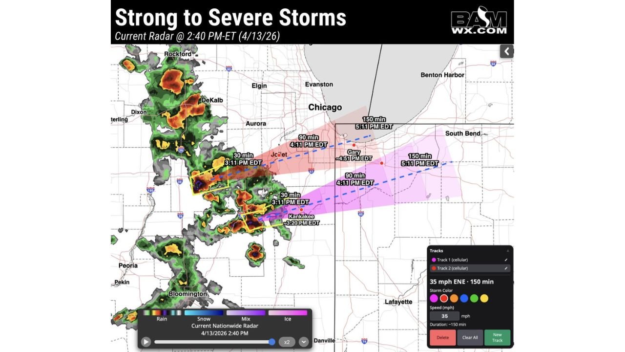
CHICAGO, IL — Strong to severe thunderstorms are already on the move across northern Illinois this Monday afternoon, and storm tracking data captured at 2:40 PM ET on April 13, 2026 shows two distinct storm cells actively tracked and racing eastward at 35 mph toward the Chicago metro, Joliet, Kankakee, Gary, Indiana, and ultimately South Bend before the early evening hours.
Large hail is the primary threat with these storms this afternoon. Residents across the storm track corridor need to be aware that these cells are moving fast and the arrival times shown in current tracking data are tight.
What the Storm Tracking Data Shows Right Now
Two cellular storm tracks are currently active and moving east-northeast at 35 mph across northern Illinois. The storm tracking projection shows a precise timeline for when each cell is expected to reach communities along its path.
Track 1 — the northern storm — is projected along a corridor through Joliet and directly toward the Chicago southside and lakefront, with the cell forecast to reach the Joliet area by approximately 3:11 PM EDT, continue toward the Chicago metro arriving around 4:11 PM EDT, and push into the Lake Michigan and Benton Harbor corridor by approximately 5:11 PM EDT.
Track 2 — the southern storm — is tracking on a slightly lower path, with the cell projected to reach Kankakee by approximately 3:20 PM EDT, push toward Gary, Indiana arriving around 4:51 PM EDT, and continue into South Bend and the northern Indiana corridor by approximately 5:11 PM EDT.
Both cells are moving at a consistent 35 mph east-northeast, giving communities in the path a narrow but real window to seek shelter before arrival.
Storm Arrival Timeline
| Location | Track | Estimated Arrival |
|---|---|---|
| Joliet, Illinois | Track 1 (Northern) | 3:11 PM EDT |
| Kankakee, Illinois | Track 2 (Southern) | 3:20 PM EDT |
| Chicago Metro and Southside | Track 1 (Northern) | 4:11 PM EDT |
| Gary, Indiana | Track 2 (Southern) | 4:51 PM EDT |
| Chicago Lakefront and Evanston | Track 1 (Northern) | 4:11 to 5:11 PM EDT |
| South Bend, Indiana | Track 2 (Southern) | 5:11 PM EDT |
| Benton Harbor, Michigan | Track 1 (Northern) | 5:11 PM EDT |
Where the Storms Are Coming From
Current radar at 2:40 PM shows the active storm cluster originating from the Rockford, DeKalb, Dixon, and Sterling corridor in northwestern Illinois, where intense radar returns in deep orange and red indicate the most organized and strongest storm cores. A separate cluster is also active near Bloomington and Peoria in central Illinois, though the two tracked cells pushing toward Chicago and Kankakee are the immediate priority for communities along the I-80 and I-55 corridors.
The broader storm field stretches from Rockford in the north through the Aurora and DeKalb corridor southward through Bloomington, covering a wide swath of northern and central Illinois with active severe weather this afternoon.
City-by-City Breakdown
Joliet and the Will County Corridor Joliet is the first major population center directly in the path of Track 1 this afternoon, with the storm cell projected to arrive by 3:11 PM EDT. That is less than 30 minutes from the time this tracking data was captured. Large hail is the primary threat. Residents and anyone outdoors in Joliet should seek sturdy shelter immediately.
Kankakee Track 2 targets Kankakee for arrival around 3:20 PM EDT. The southern cell is tracking just below the Chicago metro and will clip Kankakee before pushing into Indiana. Large hail and gusty winds are the primary concerns here.
Chicago Metro — Southside, Loop, and Lakefront Track 1 is projected to push into the Chicago metro by approximately 4:11 PM EDT, with the storm continuing northeast toward the lakefront and Evanston corridor through the 5:11 PM timeframe. Chicago residents — particularly on the south and west sides — should be indoors and away from windows before 4:00 PM. The lakefront and outdoor areas should be cleared well ahead of storm arrival.
Gary, Indiana Track 2 reaches Gary by approximately 4:51 PM EDT as it crosses the Illinois-Indiana state line. Gary and surrounding Lake County, Indiana communities should be weather-alert and sheltered before 4:30 PM.
South Bend and Benton Harbor Both tracks push into northern Indiana and southwestern Michigan by the 5:11 PM EDT timeframe. South Bend, Indiana and Benton Harbor, Michigan residents should monitor conditions and be prepared to shelter as the cells cross the state lines during the late afternoon hours.
Forecast Confidence
Confidence: High for storm track timing and direction. The two cellular tracks shown in current storm tracking data are moving at a consistent and well-established 35 mph east-northeast speed. Barring any significant deviation in storm motion — which can occur with individual cells — the arrival time projections for Joliet, Kankakee, Chicago, Gary, and South Bend are reliable guides for when residents need to be sheltered. Large hail remains the primary threat throughout the storm track corridor this afternoon, with gusty winds and frequent lightning accompanying both cells.
Do not wait to see lightning or hear thunder before seeking shelter. By the time storms are visible, the window to safely move indoors may already be closing.
More live storm tracking and severe weather coverage is always on the horizon. Stay informed at ChicagoMusicGuide.com — your source for real-time storm tracking across Chicago, northern Illinois, Indiana, and the entire United States.