The Week of April 12 to 19 Brings Heavy Rain From Texas and the Upper Midwest to Michigan and the Pacific Northwest While the Southeast Stays Bone Dry and Flash Flood Concerns Rise Across Illinois and Indiana
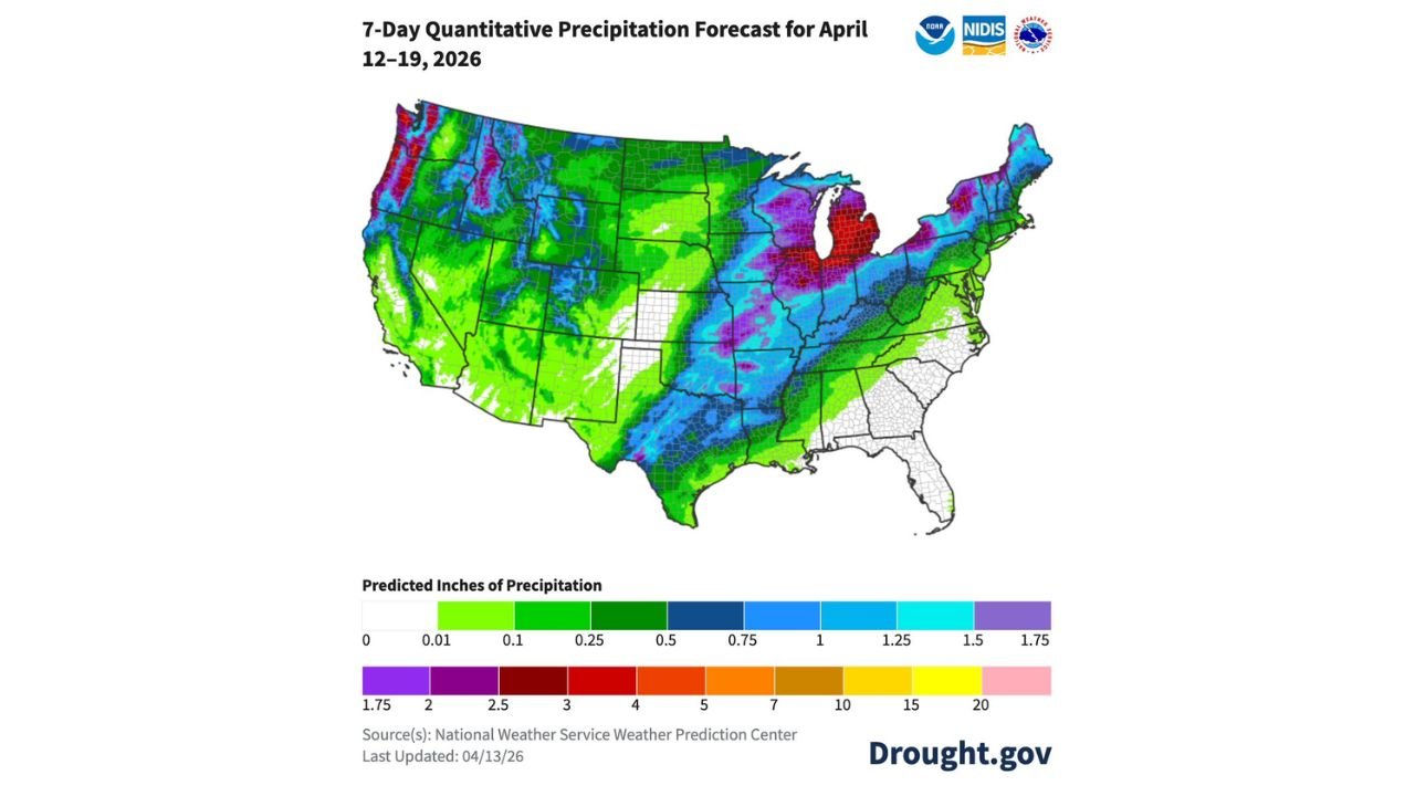
CHICAGO, IL — The seven-day precipitation forecast for April 12 through 19, 2026 is painting a divided picture of the United States — one half soaking wet, the other almost entirely dry — and the contrast between the two could not be more dramatic. A broad and active storm pattern is delivering significant rainfall totals across a massive corridor from Texas northward through the Upper Midwest into Michigan and the Great Lakes, while simultaneously rain and snow are falling across the Pacific Northwest, Rockies, and California. Meanwhile, almost the entire Southeast sits in a stark white zone on the forecast map — essentially no precipitation expected across Georgia, South Carolina, North Carolina, Florida, and much of Alabama and Mississippi through April 19.
The Wet Zone: Texas to Michigan and the Great Lakes
The most intense precipitation totals in the seven-day forecast are concentrated across two regions — the Great Lakes corridor and the Pacific Northwest — with significant but lower totals extending across the central United States from Texas through Iowa, Illinois, Indiana, and Ohio.
The deepest colors on the forecast map — dark red and crimson representing 2.5 to 4 or more inches of total precipitation — are centered over Michigan, particularly the Lower Peninsula, and extend into portions of northern Indiana, northern Ohio, and the Wisconsin-Michigan border corridor. The Detroit, Grand Rapids, Lansing, and Traverse City areas of Michigan are forecast to receive some of the heaviest seven-day totals in the entire continental United States east of the Rockies during this period.
Purple tones representing 1.75 to 2.5 inches spread across a broad zone covering Wisconsin, northern Illinois, Indiana, Ohio, and into western Pennsylvania and New York. Chicago, Milwaukee, Indianapolis, Columbus, and Pittsburgh all fall within this above-normal seven-day precipitation corridor.
Blue tones covering 1 to 1.5 inches extend the wet pattern across Iowa, Missouri, Minnesota, Kentucky, Tennessee, and southward through Arkansas into Texas. Des Moines, Kansas City, Memphis, Nashville, Dallas, and Houston all fall within this zone of meaningful weekly rainfall accumulation.
Green tones covering 0.25 to 0.75 inches reach across the remaining portions of the active corridor including Nebraska, Kansas, Oklahoma, and into Louisiana.
The Pacific Northwest and Rockies: Rain and Snow
A separate and significant precipitation zone covers the Pacific Northwest and extends into the Rockies and portions of California. The Washington and Oregon coasts show deep green to blue totals of 1 to 2-plus inches, with mountain zones across the Cascades, Northern Rockies, and portions of the Sierra Nevada receiving the heaviest totals as rain at lower elevations and snow at higher elevations. Seattle, Portland, Boise, and Salt Lake City all fall within the active precipitation zone for the week.
The Dry Zone: The Entire Southeast
The most striking feature of the seven-day forecast map is the almost complete absence of precipitation across the Southeast. A vast white zone — indicating zero to near-zero rainfall — covers virtually all of Georgia, South Carolina, North Carolina, Florida, most of Alabama and Mississippi, and extends into Virginia and coastal Maryland. Cities including Atlanta, Charlotte, Raleigh, Jacksonville, Orlando, Tampa, Miami, Columbia, and Savannah are forecast to receive essentially no meaningful rainfall through April 19.
For a region where wildfire potential is already rated above normal for April 2026 across North Carolina, South Carolina, Georgia, and Florida, a seven-day dry stretch combined with above-normal temperatures creates conditions that fire weather forecasters monitor carefully. The combination of dry soils, low humidity, and wind on any given afternoon this week across the Southeast could produce elevated fire weather conditions even without a formal fire weather watch in place.
Seven-Day Precipitation Forecast Summary
| Region | Forecast Total | Key Cities |
|---|---|---|
| Michigan — Lower Peninsula | 2.5 to 4+ inches | Detroit, Grand Rapids, Lansing |
| Wisconsin and Northern Illinois | 1.75 to 2.5 inches | Milwaukee, Chicago, Rockford |
| Indiana and Ohio | 1.75 to 2.5 inches | Indianapolis, Columbus, Cincinnati |
| Iowa and Minnesota | 1 to 1.5 inches | Des Moines, Minneapolis, Waterloo |
| Texas and Oklahoma | 0.5 to 1.5 inches | Dallas, Houston, Oklahoma City |
| Pacific Northwest | 1 to 2+ inches | Seattle, Portland |
| Rockies and California | 0.5 to 2 inches | Boise, Salt Lake City, Sacramento |
| Southeast | Near zero | Atlanta, Charlotte, Miami, Tampa |
| Desert Southwest | Near zero | Phoenix, Las Vegas |
State-by-State Breakdown
Michigan The highest seven-day precipitation totals in the eastern United States fall across Michigan this week. The Lower Peninsula is forecast to receive 2.5 to 4 or more inches of total rainfall through April 19, driven by multiple storm systems tracking through the Great Lakes corridor. Flash flooding of low-lying areas and rising river levels are concerns for Michigan communities receiving repeated rounds of heavy rain across the week.
Illinois and Indiana Chicago and northern Illinois fall inside the 1.75 to 2.5 inch weekly total zone, with central and southern Illinois receiving 1 to 1.75 inches. Indianapolis and northern Indiana are also in the 1.75 to 2.5 inch corridor. Given that soils across Illinois and Indiana are already saturated from prior storm activity, additional totals at this level will maintain elevated flash flooding potential through the week.
Wisconsin and Minnesota Milwaukee sits in the 1.75 to 2.5 inch zone while Minneapolis receives 1 to 1.5 inches through April 19. Active storm systems will continue delivering rainfall rounds across the Upper Midwest through the remainder of the week.
Texas and Oklahoma Dallas, Houston, Oklahoma City, and Tulsa fall in the 0.5 to 1.5 inch range for the seven-day period, consistent with the active southern Plains storm pattern that has defined April 2026 across this region. Repeated storm rounds keep rainfall totals accumulating across Texas and Oklahoma through April 19.
Southeast — Georgia, Florida, Carolinas Essentially no rainfall is forecast across the Southeast through April 19. Atlanta, Charlotte, Raleigh, Jacksonville, Orlando, Tampa, and Miami are all in the white zone on the seven-day forecast map. The dry stretch across this region, combined with above-normal temperatures and existing wildfire potential, creates a weather-aware week for Southeast residents even in the absence of storm activity.
Forecast Confidence
Confidence: Moderate to High for the overall pattern direction through April 19. The active storm track delivering repeated rainfall rounds from Texas through Michigan is well-established across multiple model runs. The Michigan heavy precipitation bullseye and the Southeast dry zone are both consistent and reliable signals in the current forecast. Individual storm timing and exact local totals within each zone will be refined as each system approaches, but the broad wet-versus-dry pattern shown in the seven-day outlook is unlikely to change significantly through the end of the forecast period.
More seven-day precipitation and flood risk coverage is always on the horizon. Stay informed at ChicagoMusicGuide.com — your source for weekly rainfall tracking across Texas, the Midwest, Michigan, and the entire United States.