Frost Is Not Done Yet as the Final Spring Frost Outlook Warns Chicago, Indianapolis, Cleveland and New York City Face Below 36 Degree Temperatures Through Mid-May While Dallas and Atlanta Are Finally in the Clear
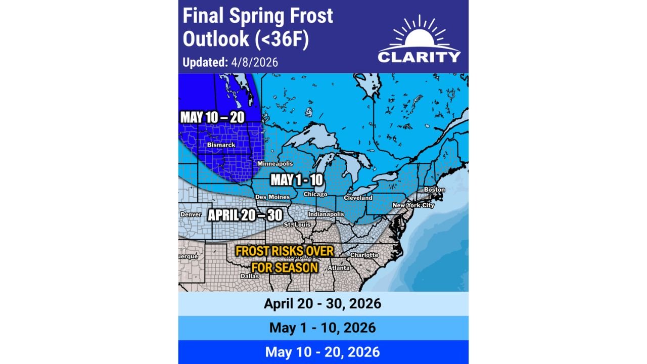
CHICAGO, IL — Spring may be in full swing across much of the country, but the final frost of the season has not arrived yet for millions of Americans across the Midwest, Great Lakes, and Northeast — and the latest frost outlook is a critical reminder for gardeners, farmers, and anyone with outdoor plants that the cold is not finished. The Final Spring Frost Outlook, updated April 8, 2026, maps out exactly when each region of the country can expect its last freeze below 36 degrees Fahrenheit, with the data carrying serious implications for late April and May planting decisions from Denver and Des Moines through Chicago, Cleveland, New York City, and all the way to Boston.
The good news for the South: Dallas, Atlanta, Charlotte, and the broader Southeast corridor are officially done with frost risk for the season. The rest of the country north of that line still has cold nights ahead.
What the Frost Outlook Is Measuring
The threshold used in this outlook is 36 degrees Fahrenheit — four degrees above the official freezing point of water. This temperature is the critical benchmark for agricultural and horticultural frost damage because many plants, seedlings, and tender crops begin experiencing cellular damage at temperatures in the 34 to 36 degree range, even before a true hard freeze occurs. A reading below 36 degrees on a clear, calm night can kill newly planted seedlings and damage fruit tree blossoms that have already opened for the season.
The outlook is divided into three time windows that define the expected last frost date for each region of the country.
The Three Frost Windows and Who Falls Inside Each
April 20 to 30, 2026 — Final Frost Zone
The southernmost active frost zone covers a broad corridor from Denver and Colorado eastward through Kansas, Missouri, Indiana, Ohio, Pennsylvania, and into the mid-Atlantic including New York City and coastal New England. Communities in this zone — including Indianapolis, St. Louis, Columbus, Pittsburgh, Philadelphia, and New York City — are expected to see their final frost of the 2026 spring season sometime during the April 20 to 30 window.
For these communities, the practical implication is clear: outdoor planting of frost-sensitive plants and vegetables should wait until after April 30 to be safe. The cold snaps expected during the late April period identified in the outlook are real and credible enough to damage unprotected plants overnight.
May 1 to 10, 2026 — Final Frost Zone
The next zone northward covers the Upper Midwest and Great Lakes corridor, including Chicago, Des Moines, Minneapolis, Cleveland, Detroit, and Boston. These communities are not expected to see their final frost until sometime during the May 1 to 10 window — meaning sub-36-degree temperatures remain a real risk across these cities well into the first week of May.
For Chicago and Cleveland residents, this is a meaningful planning data point. Planting frost-sensitive annuals, vegetables, and tender perennials before May 10 carries real risk of overnight cold damage during the coldest nights of early May. The cold snaps flagged for late April and early May in current analysis are a direct threat to early-season planting across this corridor.
May 10 to 20, 2026 — Final Frost Zone
The northernmost active frost zone covers Minnesota, the Dakotas, and the northern tier of the Great Plains including Bismarck and the Minnesota fringe. These communities should expect sub-36-degree temperatures to remain possible through the May 10 to 20 window — the latest final frost dates in the continental United States outside of the highest mountain elevations.
Final Spring Frost Outlook by Region
| Final Frost Window | Cities and Regions |
|---|---|
| Frost Risks Over for Season | Dallas, Atlanta, Charlotte, Memphis, Southeast broadly |
| April 20 to 30 | Denver, Indianapolis, St. Louis, Columbus, Pittsburgh, Philadelphia, New York City |
| May 1 to 10 | Chicago, Des Moines, Cleveland, Detroit, Minneapolis fringe, Boston |
| May 10 to 20 | Bismarck, Northern Minnesota, Northern Plains |
The Late April and Early May Cold Snap Warning
Current analysis flagged in the accompanying forecast commentary makes an important point that goes beyond the frost date map itself: a few more cold snaps are likely on the horizon as late April and early May approach, and these events will bring frost risks back into the picture across the Midwest, Great Lakes, and Northeast even as daytime temperatures climb.
This is a well-documented spring pattern phenomenon. Warm, active storm days alternate with brief but sharp cold shots behind departing storm systems. After a day of severe weather and warm temperatures, the cold front that follows can drop overnight lows back below 36 degrees across Chicago, Indianapolis, Des Moines, and Cleveland even in late April and early May. Each of those cold shots carries the potential to damage plants that were set out during the preceding warm spell.
State-by-State Planting and Frost Risk Guidance
Illinois — Including Chicago Chicago falls inside the May 1 to 10 final frost window. Frost-sensitive outdoor planting across northern and central Illinois should be held until after May 10 to safely clear the sub-36-degree temperature risk. Additional cold snaps are expected during late April that could damage unprotected plants set out prematurely.
Indiana and Ohio — Including Indianapolis and Cleveland Indianapolis falls inside the April 20 to 30 window while Cleveland sits in the May 1 to 10 zone. The difference between these two cities — separated by roughly 300 miles — illustrates how quickly the final frost date shifts northward across the Midwest. Both cities face real cold snap risk through the end of April and into early May.
Iowa and Minnesota — Including Des Moines and Minneapolis Des Moines is in the May 1 to 10 zone while Minneapolis and northern Minnesota push into the May 10 to 20 window. The Upper Midwest agricultural community faces the longest frost risk window of any major populated region in the eastern United States.
New York, Pennsylvania and New England — Including New York City and Boston New York City falls in the April 20 to 30 final frost window while Boston sits in the May 1 to 10 zone. The Northeast corridor is not immune to late spring cold snaps, and the coastal moderation that typically keeps these cities warmer overnight is not always sufficient to prevent sub-36-degree readings during the sharpest cold shots of late April.
Texas, Georgia and the Southeast Dallas, Atlanta, Charlotte, and the broader Southeast are officially done with frost risk for 2026. The southern tier of the United States has passed its final frost threshold and planting can proceed without overnight cold concerns across these regions.
Forecast Confidence
Confidence: Moderate. The Final Spring Frost Outlook represents the best available climatological and model-based assessment of when each region will see its last sub-36-degree temperature of the 2026 spring season. The broad geographic boundaries shown are well-supported. The specific dates of individual cold snaps within each window will be refined as the events approach. The key message for residents and growers across Chicago, Indianapolis, Cleveland, Des Moines, and New York City is consistent and clear: frost risk is not over yet, cold snaps are coming in late April and early May, and premature planting of frost-sensitive plants carries real risk of overnight damage through at least mid-May across the northern tier.
More spring frost and seasonal temperature outlook coverage is always on the horizon. Stay informed at ChicagoMusicGuide.com — your source for frost risk tracking and seasonal weather planning across Chicago, the Midwest, and the entire United States.