Elevated Tornado Threat Targets Minneapolis, Rochester, Eau Claire and Madison Today as Strong Storms Develop by Mid-Afternoon Across Minnesota and Wisconsin With Very Large Hail and Damaging Winds
MINNEAPOLIS, MN — An elevated and serious tornado threat is in place today across Minnesota and Wisconsin, and the outlook map now in effect leaves no room for complacency. Storms are expected to develop by mid-afternoon across southern Michigan and Wisconsin, and current analysis confirms these storms will be capable of producing all severe hazards simultaneously — very large hail, damaging winds, and tornadoes, with the potential for one strong tornado before the day is over.
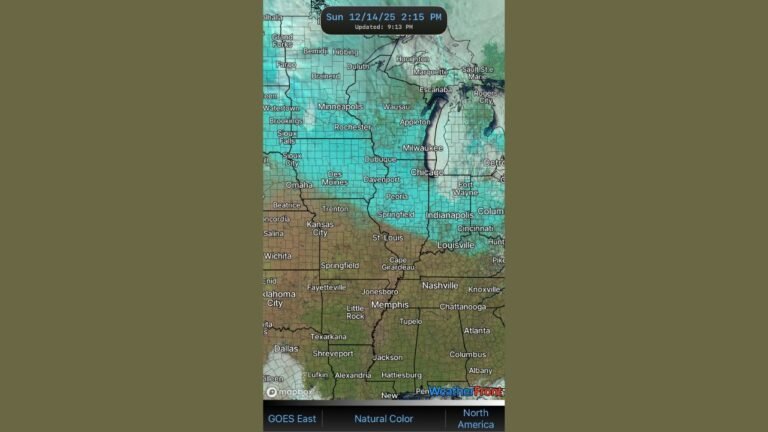
The risk zone covers a broad and heavily populated corridor from Minneapolis and Saint Cloud in the west through Rochester, Eau Claire, Madison, and Milwaukee in the center and east, with the outermost threat envelope reaching Sioux Falls, Cedar Rapids, Rockford, and the Chicago northern fringe.
What the Tornado Threat Map Is Showing
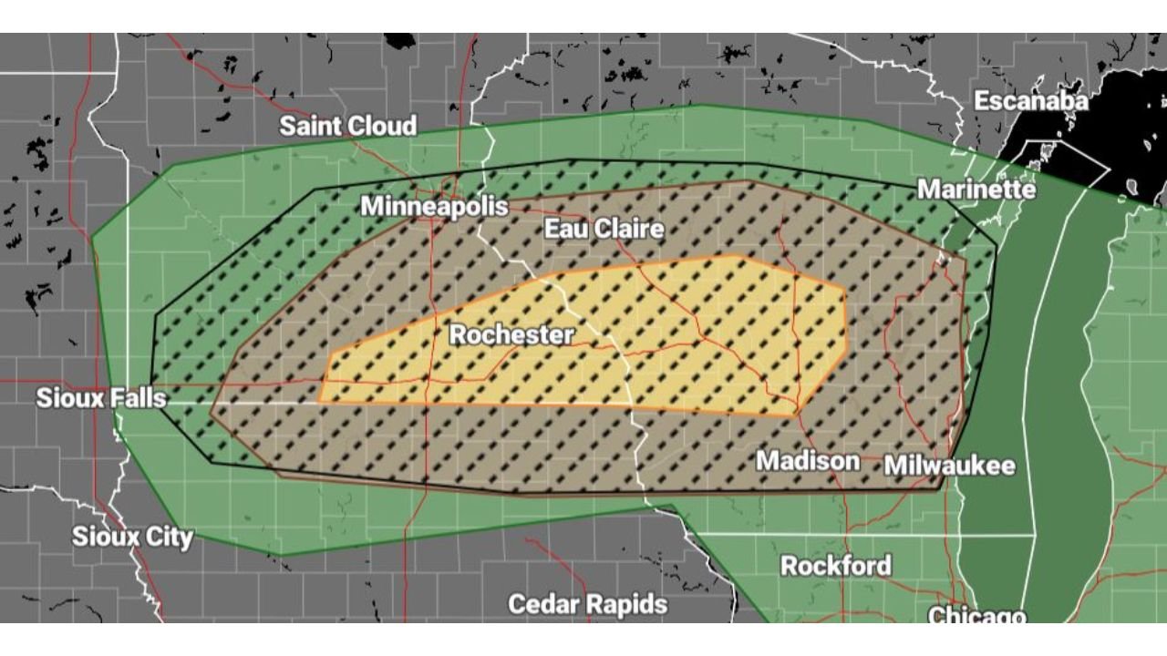
The outlook map displays three distinct risk zones nested inside each other, each carrying a different level of tornado probability for today’s event.
The innermost and highest-risk zone — shown in yellow with hatching — covers the core tornado threat corridor centered directly over Rochester, Minnesota and extending east through southern Wisconsin toward Madison. The hatching designation on this zone is the critical detail: hatching indicates the significant tornado potential, meaning forecasters are not ruling out an EF-2 or stronger tornado within this corridor today. An EF-2 produces winds of 111 to 135 mph — strong enough to destroy manufactured homes, snap large trees, and cause major damage to well-constructed structures.
The middle zone — shown in brown with hatching — surrounds the yellow core and extends the elevated tornado threat northward to include Minneapolis and Eau Claire to the west, Marinette to the northeast, and Madison and Milwaukee to the southeast. This zone carries a meaningful tornado probability with the same significant hatching notation — strong tornadoes remain possible throughout this broader corridor.
The outer zone — solid green — reaches outward to include Saint Cloud, Sioux Falls, Sioux City, Cedar Rapids, Rockford, and the Chicago northern fringe. Tornadoes are possible across this zone but at lower probability than the inner corridors.
Threat Summary by Risk Zone
| Zone | Coverage | Key Cities | Tornado Potential |
|---|---|---|---|
| Yellow Hatched Core | Highest risk | Rochester, southern Wisconsin, Madison fringe | Significant — EF-2+ possible |
| Brown Hatched Middle | Elevated risk | Minneapolis, Eau Claire, Madison, Milwaukee, Marinette | Strong tornado possible |
| Green Outer | Marginal-Slight | Saint Cloud, Sioux Falls, Cedar Rapids, Rockford, Chicago fringe | Tornadoes possible |
When Storms Arrive and What They Bring
Storm development is expected by mid-afternoon today, initiating across southern Wisconsin and Michigan before spreading through the broader Minnesota and Wisconsin corridor through the afternoon and evening hours. Once storms fire, current analysis indicates they will be immediately capable of producing all three major severe weather hazards:
Very large hail — the instability and moisture loading across this corridor today supports large hail development with the most organized supercells. Hail capable of damaging vehicles and breaking windows is expected with the strongest storm cores.
Damaging winds — straight-line wind gusts capable of downing power lines and snapping trees are expected across the full threat corridor as storms organize and move through.
Tornadoes — the primary concern today. The warm front boundary across southern Minnesota into Wisconsin is the key atmospheric feature enhancing low-level wind shear — the ingredient most directly responsible for tornado formation. Storms developing on and near this boundary have access to the most favorable tornado environment in today’s setup. One of these storms could produce a strong tornado before the evening is over.
State-by-State Breakdown
Minnesota — Minneapolis, Saint Cloud, Rochester Rochester sits inside the highest-risk yellow hatched core — the bullseye of today’s significant tornado potential. Minneapolis is inside the brown hatched middle zone with strong tornado potential. Saint Cloud falls in the outer green zone. All three communities face active severe weather this afternoon and must be weather-alert and shelter-ready before mid-afternoon.
Wisconsin — Eau Claire, Madison, Milwaukee, Marinette Eau Claire sits inside the brown hatched middle zone alongside Madison and Marinette. Milwaukee falls at the southeastern edge of the elevated risk area. Storms developing by mid-afternoon across Wisconsin will be capable of all hazards. The Madison metro in particular sits close to the yellow core boundary, making it a high-priority watch area for today’s event.
Iowa — Cedar Rapids and Northern Iowa Cedar Rapids and northern Iowa fall within the outer green zone. Organized severe thunderstorms capable of producing large hail and damaging winds are possible here, with an isolated tornado not ruled out across the northern Iowa fringe.
Illinois — Rockford and Chicago Northern Fringe Rockford and the northern Chicago suburbs fall inside the outer green zone. The threat here is lower than the Minnesota and Wisconsin core but not dismissible — strong to severe thunderstorms are possible across northern Illinois today as the system tracks southeastward through the afternoon and evening.
South Dakota — Sioux Falls Sioux Falls sits on the western edge of the outer green zone. The western fringe of today’s severe weather envelope reaches into eastern South Dakota, where isolated severe thunderstorms with large hail and gusty winds are possible.
Forecast Confidence
Confidence: Moderate to High for an active and dangerous severe weather day across Minnesota and Wisconsin. The warm front positioning and the atmospheric instability loading across the region are both well-established and consistent in current analysis. The Rochester and southern Wisconsin corridor carries the highest confidence for a significant tornado event — the yellow hatched core is not placed casually. The timing of mid-afternoon storm initiation is well-supported.
The primary uncertainty involves exactly how cleanly individual supercells can maintain their structure before any squall line consolidation occurs. Discrete supercell mode maximizes both the strong tornado and very large hail potential. Residents across Minneapolis, Rochester, Eau Claire, Madison, and Milwaukee should treat this afternoon as an immediate severe weather preparedness situation — shelter plans confirmed, weather alerts active, and outdoor activities cancelled before storms arrive.
More tornado threat and severe storm coverage is always on the horizon. Stay informed at ChicagoMusicGuide.com — your source for tornado tracking across Minnesota, Wisconsin, and the entire United States.