Texas Oklahoma Kansas And Missouri Face Ominous Supercell Signal As Severe Weather Threat Builds Toward Midwest Including Chicago
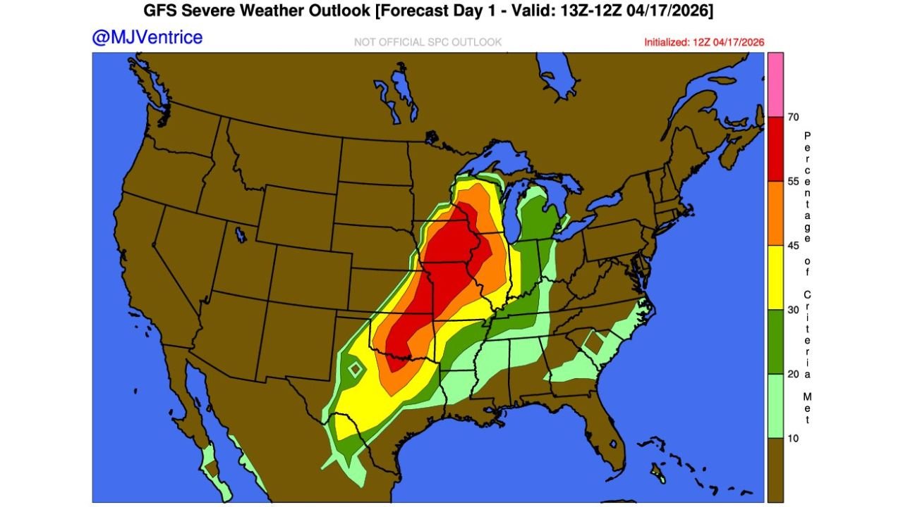
UNITED STATES — A striking new GFS severe weather outlook is raising concerns across the central United States, showing a powerful supercell signal developing from Texas through Oklahoma, Kansas, and into Missouri, with the threat potentially extending toward the Midwest including areas near Chicago. The setup suggests a high-end severe weather environment capable of producing organized storms, large hail, damaging winds, and tornadoes.
Strong Supercell Signature Emerging Across Plains
Forecast data highlights a large corridor of intense storm potential, with the most significant activity centered over Oklahoma City, Wichita, Kansas City, and into central Missouri. The structure of the outlook strongly संकेत a classic supercell pattern, where storms can remain discrete and long-lived.
This type of setup is particularly concerning because supercells are the primary producers of tornadoes and large hail. The signal shows a well-defined core of highest severe potential, suggesting that atmospheric conditions will favor:
- Strong instability (storm fuel)
- Wind shear (storm rotation)
- Organized storm structures capable of intensifying rapidly
Cities such as Tulsa, Springfield, Columbia, and Jefferson City may lie directly within this developing severe corridor.
Storm Threat Could Expand Toward Midwest And Chicago Region
As the storm system evolves, the severe threat is expected to track northeast, potentially impacting parts of the Midwest. This includes areas stretching from St. Louis toward Chicago, Milwaukee, and surrounding regions.
While the highest risk currently appears focused over the central Plains, the extension of lower but still notable severe probabilities into the Midwest suggests:
- Scattered severe storms could reach Illinois
- Wind and hail risks may increase as storms organize
- Localized tornado potential cannot be ruled out
The Chicago area may not see the most intense core of the system, but conditions could still support strong thunderstorms depending on how the system evolves.
Why This Setup Is Drawing Attention From Forecasters
The overall structure of the forecast has drawn attention due to its size and intensity, with a broad swath of severe potential and a concentrated zone of higher-end risk embedded within it.
Key reasons this setup stands out include:
- A large and continuous severe weather zone, rather than isolated pockets
- A strong central core, indicating higher confidence in storm development
- Alignment of key ingredients for rotating storms and supercells
This kind of pattern often leads to multiple rounds of severe weather, especially if storms form early and persist into the evening hours.
Potential Hazards Include Hail, Damaging Winds, And Tornadoes
If the forecast verifies, the region could face a combination of severe hazards, including:
- Large hail capable of damaging vehicles and property
- Damaging wind gusts that may cause power outages
- Tornadoes, particularly with isolated supercells
The presence of a strong supercell signal increases the likelihood that at least some storms could become significant severe events, especially in areas closest to the core risk zone.
Uncertainty Remains But Confidence In Active Pattern Growing
While this outlook is based on model guidance and not an official warning, it clearly indicates a potentially active severe weather day. As always, exact storm placement and intensity will depend on:
- Timing of storm development
- Strength of atmospheric triggers
- Evolution of the system throughout the day
Even so, the consistency in model signals suggests that residents across the Plains and Midwest should begin monitoring updates closely.
For continued coverage of severe weather threats, Midwest storm tracking, and Chicago-area forecasts, visit ChicagoMusicGuide.com and stay ahead of rapidly changing conditions.