Chicago Aurora Joliet And Kankakee Shift From Tornado Threat To Flood Risk As Storm Line Weakens But Heavy Rain Continues Across Northern Illinois
CHICAGO, ILLINOIS — A powerful line of severe thunderstorms that moved through northern Illinois has begun to weaken as it pushes east, but the threat is far from over. While the earlier tornado risk is diminishing, the focus has now shifted to heavy rainfall and potential flooding across cities including Chicago, Aurora, Joliet, Rockford, and Kankakee.
Storm Line Weakens But Heavy Rain Expands Across Region
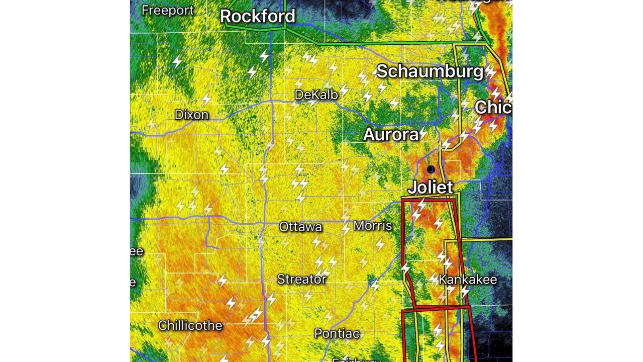
As the storm system moved into the Chicago metro area, it lost much of its severe intensity, reducing the immediate risk for tornadoes. However, radar imagery shows a broad shield of moderate to heavy rain stretching from Rockford and DeKalb through Aurora and Joliet down toward Kankakee.
Frequent lightning and embedded heavier downpours continue within the line, indicating that while the storms are no longer at peak strength, they still have the ability to produce localized hazards.
Areas such as Dixon, Ottawa, Morris, and Streator are also experiencing steady rainfall, contributing to a widespread soaking across northern and central Illinois.
Flooding Risk Becomes Primary Concern Overnight
With the storm line slowing and weakening, the biggest concern now is prolonged rainfall leading to localized flooding, especially in low-lying and flood-prone areas.
Key risk factors include:
- Repeated rounds of rain over the same locations
- Urban flooding potential in cities like Chicago and Aurora
- Rising water levels in smaller streams and drainage systems
Officials are urging residents in Joliet, Kankakee, and surrounding communities to remain alert, particularly in areas that are known to flood quickly during heavy rain events.
Rain is expected to continue for several more hours, increasing the likelihood of water accumulation on roads and reduced visibility for drivers.
Tornado Threat Diminishes As Watches Likely To Expire
Earlier in the evening, portions of northern Illinois were under a tornado watch, but with the weakening trend now evident, that threat is decreasing rapidly.
Meteorological conditions are no longer as supportive of tornado development, and any remaining watches are expected to:
- Expire naturally over time
- Be canceled early if conditions continue to stabilize
This marks a clear transition from a severe weather setup to a heavy rain event, though isolated gusty winds or lightning cannot be ruled out.
Cities Across Northern Illinois Continue To See Impacts
Even with the severe threat lowering, the storm system continues to impact a wide corridor, including:
- Chicago and Schaumburg experiencing steady rainfall and lightning
- Aurora and Joliet seeing heavier downpours at times
- Kankakee and surrounding areas remaining under the most persistent rain bands
The radar signature shows intense rainfall pockets, particularly south and southwest of Chicago, where storm cells are still producing heavier precipitation rates.
Residents Urged To Stay Cautious Despite Lower Severe Risk
Although the most dangerous phase of the storm has passed for many areas, residents should not let their guard down. Flooding can develop quickly, especially during nighttime hours when visibility is reduced.
Safety reminders include:
- Avoid driving through water-covered roads
- Monitor local alerts for flood advisories or warnings
- Stay aware of changing conditions if you live in a flood-prone area
For continued updates on Chicago weather, severe storm tracking, and regional forecasts, visit ChicagoMusicGuide.com and stay informed as this evolving weather situation continues overnight.