Severe Storms Threaten Chicago, St. Louis, Dallas and Memphis While Snow Targets Bismarck as a Major System Moves Through April 23 to 25
CHICAGO, IL — A significant weather system is already on forecasters’ radar for late next week, and the setup taking shape for Thursday, April 23 through Saturday, April 25, 2026 carries two very different stories depending on where you live. Across the Northern Plains, snow is the headline. Across the central United States from Dallas and Houston northward through St. Louis, Chicago, Des Moines, and Indianapolis, the focus is on the return of severe thunderstorms and the best chances for organized storm activity seen in the region in days.
This is still a multi-day outlook, and details will sharpen considerably by early next week — but the overall pattern is consistent enough that preparation awareness is warranted right now.
The Two-Sided Storm System
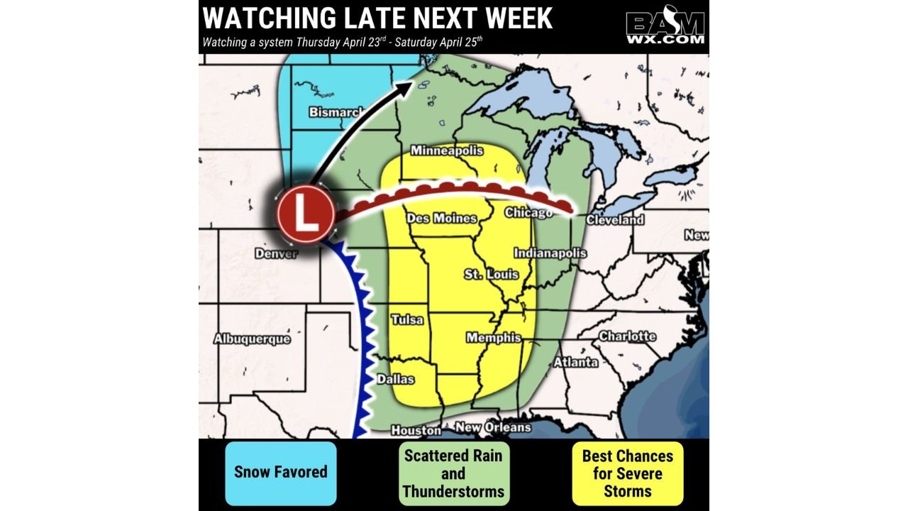
A well-defined low-pressure center is expected to develop and track from near Denver northeastward toward Bismarck between Thursday and Saturday. This track is the key to understanding the dual nature of next week’s event.
On the cold side of the low — to the north and west — snow is favored across the Northern Plains corridor including Bismarck and the Dakotas. The arrow on current tracking maps shows the low’s projected track curving toward the Upper Midwest, pulling cold air southward behind it while simultaneously dragging warm, moist Gulf air northward ahead of it on the warm side of the system.
That warm sector air feeding northward ahead of the low is what drives the severe weather threat across the central United States.
A warm front — depicted as the red scalloped boundary on the map — is shown stretching from near Denver eastward through Des Moines toward Chicago and Cleveland. Warm fronts are critical boundaries for severe weather forecasters because they mark the zone where the most extreme atmospheric instability and low-level wind shear — the two ingredients most responsible for tornadoes and large hail — are concentrated.
A cold front follows behind the low, shown as the blue boundary pushing southward from Denver toward Texas. The intersection of the warm front and cold front with the low-pressure center creates the classic severe weather setup that forecasters monitor most carefully across the central United States in spring.
Where the Severe Weather Threat Is Focused
The best chances for severe storms — shown in yellow on the tracking map — cover a corridor from Houston and Dallas in the south northward through Tulsa, Memphis, St. Louis, Des Moines, Chicago, and Indianapolis. This yellow zone represents the area where the warm sector moisture, instability, and wind shear will be most concentrated between Thursday and Saturday.
A broader green zone of scattered rain and thunderstorms surrounds the yellow core, extending the active weather threat outward to include Minneapolis, Cleveland, Atlanta, Charlotte, New Orleans, and the broader Midwest and Southeast.
The snow-favored zone in blue covers the Northern Plains from near Denver northward through Bismarck, where the cold side of the system will deliver late-season snowfall.
System Breakdown by Zone
| Zone | Threat | Key Cities | Timing |
|---|---|---|---|
| Yellow — Best Severe Chances | Organized severe storms | Dallas, Houston, Tulsa, Memphis, St. Louis, Chicago, Des Moines, Indianapolis | April 23 to 25 |
| Green — Scattered Rain and Storms | General thunderstorms | Minneapolis, Cleveland, Atlanta, Charlotte, New Orleans | April 23 to 25 |
| Blue — Snow Favored | Late season snowfall | Bismarck, Northern Plains, Dakotas | April 23 to 25 |
State-by-State Breakdown
Illinois — Chicago and Statewide Chicago sits inside the yellow best-chance severe storm corridor for the April 23 to 25 window. The warm front boundary is projected to pass directly through the Chicago metro during this period, placing the city in the zone of maximum atmospheric instability and wind shear. Severe thunderstorms capable of producing large hail, damaging winds, and tornadoes are possible across Illinois during this event.
Iowa and Missouri — Des Moines and St. Louis Both Des Moines and St. Louis fall squarely inside the yellow severe storm corridor. The low-pressure track passing through this region Thursday into Friday will drive storm development directly over these communities. Missouri and Iowa have already seen multiple rounds of severe weather this April, and late next week adds another serious threat to the calendar.
Texas and Oklahoma — Dallas, Houston and Tulsa The southern end of the severe storm corridor reaches Dallas, Houston, and Tulsa. These communities sit at the base of the yellow zone where Gulf moisture will be deepest and the cold front interaction most aggressive. Severe thunderstorms with all hazards are possible across north and central Texas and Oklahoma Thursday into Friday.
Tennessee — Memphis Memphis sits inside the yellow best-chance severe corridor, positioned between the Texas and Midwest portions of the threat zone. Severe storms tracking through the Mississippi Valley corridor Thursday through Saturday will include Memphis in their path.
Indiana — Indianapolis Indianapolis falls inside the yellow zone, sharing the severe storm potential with Chicago and St. Louis. The warm front boundary and low-pressure track keep Indiana in the active weather corridor for the full April 23 to 25 window.
North Dakota — Bismarck Bismarck and the Northern Plains are on the cold side of the system where snow is favored. Late April snowfall across the Dakotas is not unprecedented, and this system carries enough cold air advection behind the low to deliver accumulating snow across the northern tier during the same period that severe storms impact the central and southern states.
Forecast Confidence
Confidence: Low to Moderate — and that is appropriate for a storm system still five to seven days away. The overall pattern signal is consistent and well-supported across multiple model runs, giving forecasters enough confidence to highlight the April 23 to 25 window as a significant weather event for the central United States. The specific details — exact storm track, timing of the warm front passage, and which communities fall inside the highest-risk zone — will come into sharper focus by Monday and Tuesday as the system approaches.
Residents across Chicago, St. Louis, Des Moines, Dallas, Memphis, and Indianapolis should bookmark this date range and plan to check updated forecasts early next week.
More extended severe weather and winter storm outlook coverage is always on the horizon. Stay informed at ChicagoMusicGuide.com — your source for multi-day storm tracking across the Plains, the Midwest, and the entire United States.