Two California Rainstorms and a Return of Severe Weather Threaten Illinois, Wisconsin, Missouri and Kansas From Thursday Into the Weekend
CHICAGO, IL — The national weather pattern is not slowing down. As of Saturday, April 18, 2026, a two-pronged storm sequence is taking shape that will affect both coasts and the central United States over the next ten days — bringing much-needed rainfall to California and Arizona, triggering a return of severe weather across the Upper Midwest and Plains, and maintaining an above-normal precipitation signal across virtually the entire eastern half of the country through the end of April and into early May.
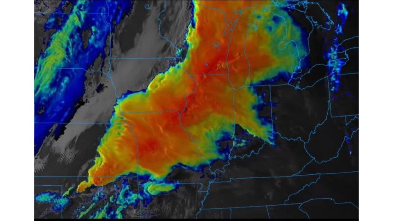
The satellite imagery captured Saturday afternoon shows a massive, organized cloud shield already draped across the Upper Midwest and Great Lakes corridor — the remnant of the storm system that produced significant weather across the region Friday night — with the next round of energy already cycling in from the west.
Two California Storm Systems Back to Back
Current analysis confirms California is in line for two distinct precipitation events over the coming ten days, both bringing meaningful rainfall to a state that has been watching its drought and wildfire indicators carefully through the spring.
The first system arrives Tuesday, April 21, targeting much of California with widespread rainfall. This event carries higher forecaster confidence following multiple consistent model runs showing the system tracking onshore across the California coast midweek. The second and potentially more impactful system follows for the upcoming weekend, with southern California and Arizona as the primary targets from April 26 through April 28. Current analysis indicates this second storm will push further south than the first, bringing significant moisture to the Los Angeles, San Diego, and Phoenix corridors during the final days of April.
Severe Weather Returns to the Midwest Thursday and Friday
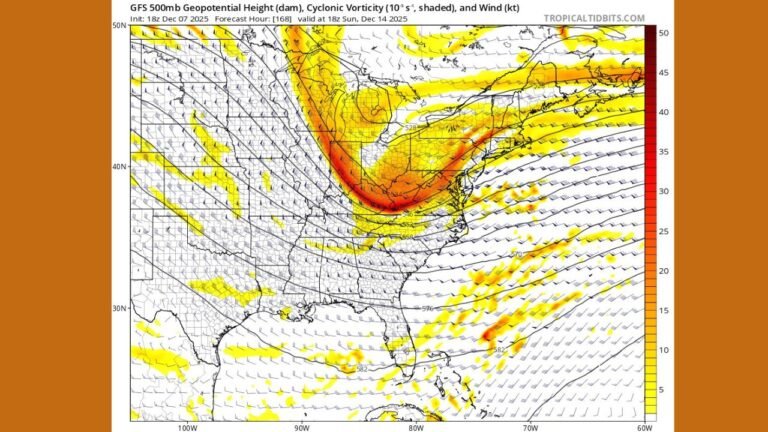
For residents across Illinois, Wisconsin, Missouri, Kansas, and potentially Indiana, the more immediately urgent piece of this outlook is the return of severe weather expected Thursday into Friday. Current analysis indicates the California system that arrives midweek will eject eastward out of the Rockies and reload across the Upper Midwest and central Plains by Thursday — targeting the same general corridor that saw active severe weather Friday night.
Illinois, Wisconsin, Missouri, Kansas, and Indiana are all identified as states in the path of this returning severe weather threat. The pattern favors a repeat performance across communities that are already familiar with this week’s storm activity — meaning Chicago, Milwaukee, St. Louis, Kansas City, and surrounding metro areas should be watching Thursday and Friday closely for the next round of organized storm development.
Extended Precipitation Outlook: April 24 Through May 2
The NOAA 6-10 Day Precipitation Outlook, valid April 24 through 28 and issued April 18, 2026, shows above-normal precipitation probability covering the vast majority of the continental United States. The highest probability of above-normal rainfall — depicted in the deepest green on the outlook map — is centered over California, Nevada, Utah, Colorado, New Mexico, and Arizona, where the second storm system drives the most confident above-normal signal.
A broad lighter green zone covers essentially the entire central and eastern United States from the Plains through the Great Lakes, Ohio Valley, Southeast, and Northeast — all showing leaning-above to likely-above normal precipitation probabilities for the April 24 to 28 window. The only areas trending below normal are the Pacific Northwest coast and the Oregon border region.
The 8-14 Day Outlook, valid April 26 through May 2, maintains a similar pattern. California and the Southwest remain in the highest above-normal probability zone. The Southeast — including Alabama, Georgia, Mississippi, Tennessee, and Florida — develops a stronger above-normal precipitation signal in the extended window, suggesting the active storm track shifts southward as April closes and May opens. The Pacific Northwest stays below normal through this period.
Precipitation Outlook Summary
| Period | Highest Above-Normal Zone | Secondary Zone | Below Normal |
|---|---|---|---|
| April 24 to 28 | California, Southwest, Arizona | Entire central and eastern US | Pacific Northwest, Oregon |
| April 26 to May 2 | California, Southwest | Southeast, Plains, Great Lakes | Pacific Northwest |
State-by-State Breakdown
California — Los Angeles, San Diego, Sacramento, San Francisco Two storm systems arriving April 21 and April 26 to 28 bring back-to-back above-normal rainfall to California. The first targets the state broadly while the second focuses on southern California. Both events carry higher-than-usual confidence in the current outlook.
Arizona — Phoenix and Tucson The second storm system arriving April 26 to 28 pushes into Arizona, bringing above-normal precipitation to Phoenix and Tucson — communities that rarely see late April storm systems of this magnitude. Flash flooding of desert washes and low-water crossings will need monitoring during this event.
Illinois, Wisconsin, Missouri and Kansas The most urgent near-term message for the Midwest: severe weather returns Thursday into Friday. The same communities that experienced Friday night’s storm activity are in the path of the next system. Chicago, Milwaukee, St. Louis, Kansas City, and Indiana border communities should be monitoring Thursday’s evolution closely. The 6-10 day outlook also keeps the entire Midwest in above-normal precipitation territory through April 28.
Southeast — Alabama, Georgia, Tennessee, Mississippi, Florida The 8-14 day outlook shows a strengthening above-normal precipitation signal developing across the Southeast from April 26 through May 2. Atlanta, Nashville, Birmingham, Jackson, and Tampa are all positioned inside this emerging wet signal for the end of April into early May.
Northeast and Mid-Atlantic — New York, Philadelphia, Boston, Washington D.C. Above-normal precipitation probability covers the entire Northeast through the April 24 to 28 window. Multiple storm systems tracking through the Ohio Valley will send moisture and precipitation northeastward through this corridor as the pattern remains active.
Pacific Northwest — Seattle, Portland The only consistently below-normal precipitation signal in both outlook windows falls across the Pacific Northwest. Seattle and Portland trend drier than normal through the end of April and into early May, maintaining the dry spring signal that has characterized this region for several weeks.
Forecast Confidence
Confidence: Moderate to High for the overall pattern direction through April 28. The California Tuesday storm carries high confidence. The April 26 to 28 southern California and Arizona system carries moderate-to-high confidence. The Thursday to Friday Midwest severe weather threat is a real and credible signal but carries the inherent uncertainty of a 5 to 6 day severe weather forecast — timing and exact track will sharpen considerably by Wednesday.
The broad above-normal precipitation signal across the central and eastern United States through the end of April is one of the most consistent features in the extended outlook and is unlikely to change direction significantly heading into the final week of the month.
More extended pattern and severe weather outlook coverage is always on the horizon. Stay informed at ChicagoMusicGuide.com — your source for multi-day storm tracking across California, the Midwest, the Southeast, and the entire United States.