Heavy Rain Soaks Memphis, Nashville, Chicago and Houston Over the Next Seven Days as Forecast Totals of 1 to 6 Inches Hit the Central United States Through April 25
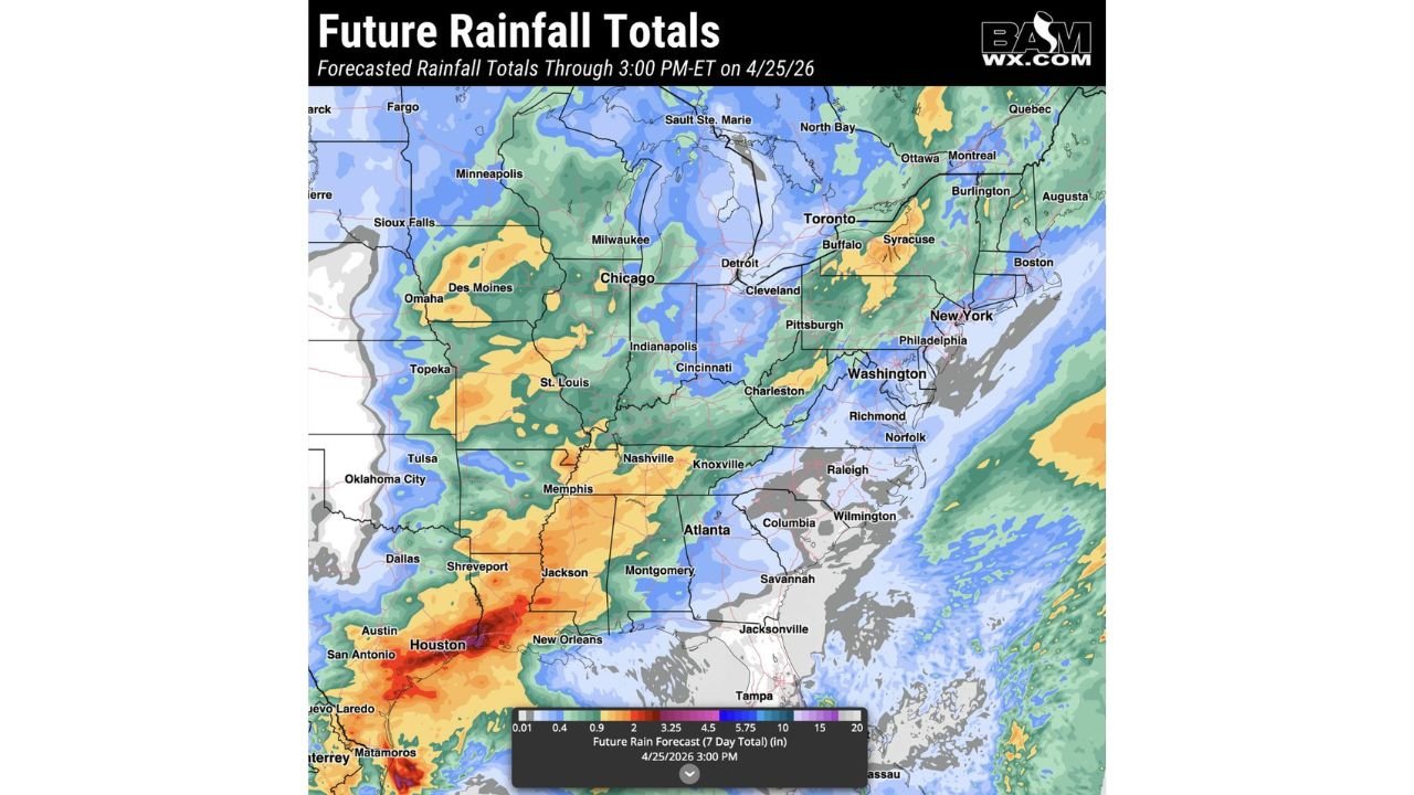
NASHVILLE, TN — A relentless stretch of active spring weather is keeping the central and southern United States wet through the end of April, and the seven-day rainfall forecast through 3:00 PM ET on April 25, 2026 shows significant accumulations building across a massive corridor from Houston and New Orleans northward through Memphis, Nashville, St. Louis, Chicago, and Indianapolis.
The map tells a clear story: if you live between Texas and the Great Lakes, rain is coming — and in several locations, it is coming in meaningful and potentially problematic amounts.
The Heaviest Totals: Houston and the Gulf Coast Lead the Nation
The deepest rainfall totals in the seven-day forecast are concentrated across the Houston, Texas corridor and the surrounding Gulf Coast, where forecast totals reach into the 5 to 10-plus inch range — shown in deep red and crimson on the forecast map. Houston, Shreveport, New Orleans, San Antonio, and Austin are all positioned inside the heaviest rainfall corridor of the entire outlook period. At these totals, flash flooding of low-lying areas, bayous, and urban drainage systems is not a possibility — it is an expectation. Residents across the Houston metro in particular should monitor conditions closely through April 25 given the city’s well-documented vulnerability to heavy rainfall accumulation events.
The Central Corridor: Memphis, Nashville, St. Louis and Chicago
Moving northward from the Gulf Coast, the rainfall forecast shows orange tones representing 2 to 4.5 inches across a broad corridor covering Memphis, Nashville, Jackson, Knoxville, St. Louis, Indianapolis, and Cincinnati. Tennessee and Kentucky are specifically highlighted in the forecast commentary as areas expected to receive 1 to 2 inches of rain over the next week — a meaningful total that will keep soils saturated and maintain elevated runoff potential across the mid-South through the end of April.
Memphis sits at the intersection of the heaviest southern totals and the active central corridor, making it one of the most rainfall-impacted major cities in the seven-day outlook outside of Houston.
Chicago falls in the yellow to orange range of 1 to 3 inches for the seven-day period, consistent with multiple storm systems expected to track through the Great Lakes corridor through April 25. Milwaukee, Detroit, Cleveland, and Indianapolis fall in similar ranges, keeping the entire Great Lakes and Ohio Valley corridor in an active and above-normal rainfall pattern through the end of the month.
Seven-Day Rainfall Forecast by City
| City | Forecast 7-Day Total | State |
|---|---|---|
| Houston | 5 to 10+ inches | Texas |
| New Orleans | 4 to 7 inches | Louisiana |
| Shreveport | 3 to 6 inches | Louisiana |
| Memphis | 2 to 4.5 inches | Tennessee |
| Nashville | 1 to 3 inches | Tennessee |
| Jackson | 2 to 4 inches | Mississippi |
| St. Louis | 1.5 to 3 inches | Missouri |
| Chicago | 1 to 3 inches | Illinois |
| Indianapolis | 1 to 2.5 inches | Indiana |
| Cincinnati | 1 to 2 inches | Ohio |
| Oklahoma City | 1 to 2 inches | Oklahoma |
| Dallas | 1 to 2 inches | Texas |
| Minneapolis | 0.5 to 1.5 inches | Minnesota |
The Dry Zones: Southeast Coast and the Northeast
Two notable dry pockets stand out on the seven-day forecast map. The Southeast coastal corridor — including Raleigh, Columbia, Savannah, Jacksonville, and Tampa — falls in a relatively dry zone with minimal to near-zero rainfall forecast through April 25. The same dry signal that has characterized the Southeast for much of April continues through the end of the month for these communities.
The Northeast corridor including New York City, Philadelphia, Washington D.C., Boston, and Richmond also trends on the drier side for the seven-day period, with light blue tones indicating modest 0.5 to 1 inch totals at best across much of the region.
State-by-State Breakdown
Texas and Louisiana The heaviest rainfall in the entire outlook. Houston leads the nation with forecast totals potentially exceeding 10 inches through April 25. Flash flooding is a serious and ongoing concern. New Orleans, Shreveport, Austin, and San Antonio all face significant rainfall accumulation through the end of the period.
Tennessee, Mississippi and Kentucky Memphis, Nashville, Jackson, and Knoxville all receive 1 to 4.5 inches over the seven-day window. Tennessee and Kentucky are specifically identified in the forecast as receiving 1 to 2 inches through next week, keeping river levels elevated and soils saturated across the mid-South.
Illinois and Missouri Chicago and St. Louis receive 1 to 3 inches through April 25, consistent with multiple storm systems tracking through the region. Flash flooding of urban areas and low-lying roads remains possible with the heavier rain events embedded within the seven-day total.
Oklahoma and Kansas Oklahoma City and Tulsa fall in the 1 to 2 inch range, continuing the above-normal spring precipitation pattern across Oklahoma that has been a defining feature of April 2026.
Minnesota and the Northern Plains Minneapolis and Sioux Falls trend in the 0.5 to 1.5 inch range — lighter than the southern corridor but still above the near-zero readings seen across the dry zones to the east and southeast.
Forecast Confidence
Confidence: Moderate to High for the overall rainfall distribution through April 25. The heaviest totals near Houston and the Gulf Coast are the most certain feature in the outlook, supported by a persistent onshore moisture flow pattern. The central corridor totals from Memphis through Chicago carry moderate confidence with individual storm system timing introducing some variability in exactly where the heaviest bands set up within the broader wet zone. The dry signal across the Southeast coast and Northeast is also well-supported and consistent across multiple forecast runs.
More rainfall forecast and flood risk coverage is always on the horizon. Stay informed at ChicagoMusicGuide.com — your source for seven-day precipitation tracking across Tennessee, Illinois, Texas, and the entire United States.