Friday’s Severe Weather Outbreak Verified Across the Midwest as 319 Wind Reports and 233 Hail Reports Confirm a Major Storm Event Hit Illinois, Wisconsin and Indiana
CHICAGO, IL — The numbers are in, and they confirm what residents across Illinois, Wisconsin, Indiana, and the broader Upper Midwest experienced firsthand on Friday, April 17, 2026: a significant and well-verified severe weather outbreak that delivered hundreds of damaging wind and large hail reports across a corridor stretching from the southern Plains northward through the Great Lakes.
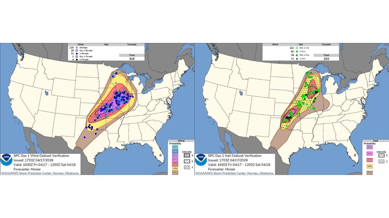
The Storm Prediction Center’s official Day 1 verification maps, issued at 1703Z on April 17, 2026 and valid through Saturday morning, show the forecast performed with strong accuracy — and the observed storm reports confirm that the atmospheric environment delivered exactly what forecasters warned it would.
The Wind Verification: 319 Total Reports
The wind verification map tells the most dramatic story of Friday’s event. A total of 319 wind damage and damaging gust reports were logged across the outbreak corridor — a number that places this event firmly in the category of a major severe weather day by any historical measure.
Of those 319 total wind reports:
225 reports were confirmed wind damage events — meaning physical destruction to trees, structures, power lines, or other infrastructure was documented at those locations. This is the most significant category because it represents real, confirmed impacts rather than estimated readings.
71 reports logged measured or estimated wind gusts of 58 mph or greater — the threshold for a severe thunderstorm wind report.
18 reports registered estimated gusts of 58 mph or greater at locations without direct measurement.
4 reports confirmed measured wind gusts of 75 mph or greater — a destructive wind speed capable of causing major structural damage and comparable to a strong tropical storm.
1 report estimated gusts at 75 mph or greater.
The highest density of wind reports is concentrated across northern Illinois, Wisconsin, Indiana, and into Michigan, precisely matching the forecast risk corridors that had been highlighted in the days leading up to the event. The hatched zone on the wind verification map — indicating the area where the highest wind probabilities were forecast — lines up almost exactly with the densest cluster of blue damage dots across the Chicago, Milwaukee, Indianapolis, and Detroit corridor.
The Hail Verification: 233 Total Reports
The hail verification map confirms 233 total hail reports across the outbreak corridor, with two distinct geographic clusters matching the two primary storm zones that developed Friday.
Of those 233 total hail reports:
82 reports confirmed hail of 1 inch or greater in diameter — the threshold for severe hail, roughly the size of a quarter and large enough to cause vehicle and property damage.
122 reports estimated hail at 1 inch or greater.
11 reports confirmed hail of 2 inches or greater in diameter — golf ball-sized hail capable of shattering windows, punching through car roofs, and causing serious injury.
18 reports estimated hail at 2 inches or greater.
The northern hail cluster is concentrated across northern Illinois, Wisconsin, and into Michigan, while a separate southern cluster shows hail reports across Kansas and Oklahoma — both corridors matching the forecast zones almost exactly.
Verified Storm Report Summary
| Category | Confirmed Reports | Estimated Reports | Total |
|---|---|---|---|
| Wind Damage | 225 | — | 225 |
| Wind 58 mph or greater | 71 | 18 | 89 |
| Wind 75 mph or greater | 4 | 1 | 5 |
| Total Wind Reports | — | — | 319 |
| Hail 1 inch or greater | 82 | 122 | 204 |
| Hail 2 inches or greater | 11 | 18 | 29 |
| Total Hail Reports | — | — | 233 |
Where the Verified Reports Were Concentrated
Illinois and Wisconsin The densest cluster of both wind and hail reports falls across northern Illinois and Wisconsin, directly over the Chicago metro and Milwaukee corridor. The concentration of blue wind damage dots across this zone on the verification map is among the highest anywhere in the country for Friday’s event. 225 wind damage reports across the full corridor underscores just how widespread the destructive wind impacts were from these storms.
Indiana and Michigan Indiana and Michigan show significant wind report concentrations extending the damage corridor eastward from Illinois and Wisconsin. The storm system maintained its intensity as it pushed through these states Friday evening, delivering additional confirmed wind damage and large hail across Indianapolis, Fort Wayne, and into western Michigan.
Kansas and Oklahoma The separate southern storm corridor produced its own verified hail cluster across Kansas and Oklahoma, with confirmed reports of hail at 1 inch or larger scattered across both states. This southern zone operated independently from the primary Great Lakes outbreak corridor but added to the national total for the day.
What the Verification Confirms
Friday’s storm event was not just a forecast success — it was a major, real-world severe weather outbreak that physically impacted hundreds of communities across the Upper Midwest. The combination of 225 confirmed wind damage reports and 11 confirmed 2-inch-or-larger hail reports within a single 24-hour period reflects a storm system that performed at the high end of its forecast potential.
For residents across northern Illinois, Wisconsin, Indiana, and Michigan who experienced power outages, fallen trees, damaged vehicles, and property damage Friday evening — the verification data confirms that what they experienced was part of a widespread, well-documented severe weather event that stretched across multiple states simultaneously.
More severe weather verification and outbreak coverage is always on the horizon. Stay informed at ChicagoMusicGuide.com — your source for storm report verification and severe weather tracking across Illinois, Wisconsin, Indiana, and the entire United States.