Four Days of Severe Weather Are Coming to the Southern United States as Oklahoma, Texas, Arkansas and the Mid-South Face Threats From Thursday Through Monday
OKLAHOMA CITY, OK — Thursday is just the beginning. A multi-day severe weather sequence is taking shape across the southern United States that will keep Oklahoma, Texas, Kansas, Arkansas, Louisiana, Tennessee, and the broader mid-South on alert from Thursday, April 23 through Monday, April 27, 2026. Each day brings a distinct risk zone, a shifting storm track, and a fresh round of organized severe weather potential across one of the most storm-vulnerable corridors in the country.
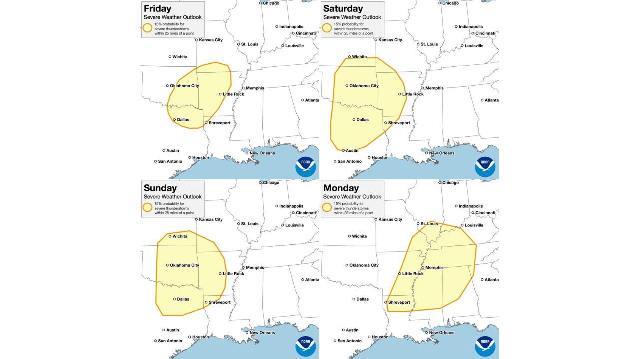
The four-panel outlook and the day-by-day NOAA maps tell the story clearly: this is not a one-day event. It is a sustained, multi-system severe weather pattern that demands preparation today — not the day the storms arrive.
How the Four-Day Pattern Unfolds
Thursday — The Kickoff: Oklahoma City, Little Rock and Dallas
Thursday opens the sequence with a severe weather zone covering Oklahoma City, Little Rock, Dallas, and Shreveport. The risk polygon on the four-panel map shows the threat concentrated over central Oklahoma, western Arkansas, and north Texas — the classic southern Plains and Ark-La-Tex corridor that has been identified as an active zone throughout late April. Thursday is the opening act, but current analysis makes clear it will not be the most significant day of the sequence.
Friday — Oklahoma City, Dallas and Shreveport
The Friday NOAA outlook shows a 15% severe thunderstorm probability zone — the Slight Risk threshold — covering Oklahoma City, Dallas, Little Rock, and Shreveport. The risk polygon tightens compared to Thursday, focusing the highest probability over central Oklahoma and north Texas. The storm track on Friday keeps the threat west of the Mississippi River, with Memphis and St. Louis sitting outside the primary zone but close enough to monitor.
Saturday — Wichita, Oklahoma City, Dallas and Austin
Saturday’s outlook expands the risk zone significantly both northward and southward. The 15% probability polygon now covers Wichita in the north, through Oklahoma City and Dallas, southward to Austin — one of the largest geographic footprints of the four-day sequence. This is the day when Kansas enters the picture alongside Texas and Oklahoma, with the risk stretching from the southern Kansas border all the way to central Texas. Current analysis indicates Saturday may represent the peak geographic coverage day of the entire multi-day event.
Monday — St. Louis, Memphis, Little Rock and Louisville
Monday’s outlook marks the most dramatic geographic shift of the entire sequence. The risk zone pivots entirely eastward, abandoning the Plains and targeting the Ohio Valley and mid-South corridor. The 15% probability polygon covers St. Louis, Louisville, Memphis, Little Rock, and Shreveport — a zone that sits squarely in Dixie Alley and the Ohio Valley, regions that have seen limited organized severe weather for an extended period. Monday is when the pattern delivers its energy to the eastern side of the corridor, and damaging winds and tornadoes are the primary concerns for this day.
Four-Day Outlook Summary
| Day | Primary Risk Zone | Key Cities | 15% Probability |
|---|---|---|---|
| Thursday | Central OK, W. Arkansas, N. Texas | Oklahoma City, Little Rock, Dallas | Yes |
| Friday | Central OK, N. Texas, Ark-La-Tex | Oklahoma City, Dallas, Shreveport | Yes |
| Saturday | S. Kansas through Central Texas | Wichita, OKC, Dallas, Austin | Yes |
| Monday | Ohio Valley and mid-South | St. Louis, Louisville, Memphis, Little Rock | Yes |
State-by-State Breakdown
Oklahoma Inside the risk zone on Thursday, Friday, and Saturday — three consecutive days of severe weather potential. Oklahoma City appears in the primary risk corridor on all three days. The atmosphere across Oklahoma will be repeatedly disturbed through the weekend, and storm development on any of the three days carries the potential for large hail, damaging winds, and tornadoes.
Texas Dallas and Shreveport are inside the risk zone Thursday through Saturday. Austin enters the picture on Saturday as the risk zone expands southward. North and central Texas face the most consistent multi-day exposure of any state in the sequence outside of Oklahoma.
Kansas Wichita enters the risk zone on Saturday as the storm track expands northward. Southern Kansas has been an active severe weather corridor throughout April 2026, and Saturday’s setup brings another round of organized storm potential to the region.
Arkansas Little Rock appears in the risk zone on Thursday, Friday, and again on Monday as the pattern shifts eastward. Arkansas faces exposure on both ends of this multi-day sequence — early in the week from the Plains storm track and again Monday as the system ejects into Dixie Alley.
Missouri, Tennessee and Kentucky St. Louis, Memphis, and Louisville are Monday’s primary targets as the risk zone shifts east. This is the day the Ohio Valley and mid-South take the brunt of the pattern’s final push, with damaging winds and tornadoes as the lead threats.
Louisiana Shreveport appears in the risk zone on Thursday, Friday, and Monday. The Ark-La-Tex corridor — where Arkansas, Louisiana, and Texas converge — is one of the most consistently targeted zones across the full four-day sequence.
Forecast Confidence
Confidence: Low to Moderate across all four days given the extended lead time. The geographic placement of each day’s risk zone will sharpen considerably as each event approaches. What carries the highest confidence right now is the overall pattern direction — the southern United States will see repeated rounds of organized severe weather from Thursday through Monday, with the storm track beginning in Oklahoma and Texas and ending in the Ohio Valley and mid-South by early next week.
Do not wait until the day of the threat to make a plan. All residents across Oklahoma, Texas, Kansas, Arkansas, Missouri, Tennessee, and Kentucky should establish their shelter plan, confirm their weather alert sources, and monitor daily forecast updates through the remainder of this week.
More multi-day severe weather outlook coverage is always on the horizon. Stay informed at ChicagoMusicGuide.com — your source for southern storm tracking across Oklahoma, Texas, Arkansas, and the entire United States.