Rain and Storms Move Into Alabama Friday Evening Bringing Much-Needed Moisture to Birmingham, Tuscaloosa and Montgomery With a Marginal Severe Risk for Far Western Alabama
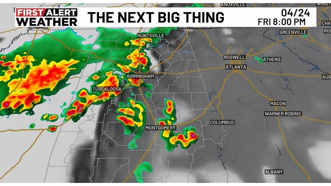
BIRMINGHAM, AL — After a prolonged dry stretch across much of Alabama, rain is finally arriving — and for most of the state, that is genuinely welcome news. Storms are expected to push into Alabama Friday evening, April 24, 2026, with the future radar projection for 8:00 PM Friday showing organized storm activity already sweeping through Huntsville, Birmingham, Tuscaloosa, and Montgomery as the system moves eastward through the night.
The overall severe weather risk for Alabama on Friday remains low, but isolated storms within the line could still produce frequent lightning and gusty winds before the system clears.
What Is Coming Friday Evening
Current analysis shows a line of rain and thunderstorms approaching Alabama from the west Friday afternoon and pushing through the state during the evening hours. The 8:00 PM radar projection shows the most active storm cores positioned near Huntsville and Tuscaloosa in the north and west, with additional cells developing near Montgomery in central Alabama as the system expands southward through the evening.
The Storm Prediction Center has placed far western Alabama inside a Level 1 Marginal Risk — the lowest tier on the five-level severe weather scale — for Friday. This designation reflects that while widespread organized severe weather is not expected, isolated storms within the system carry a non-zero potential for gusty winds and frequent lightning that can create hazardous conditions for anyone caught outdoors.
For the vast majority of Alabama, Friday’s storm system is a rain event first and a severe weather concern second. The state has been running well below normal on rainfall through the spring dry stretch, and this system represents meaningful precipitation relief for Birmingham, Tuscaloosa, Montgomery, and surrounding communities.
Friday Evening Storm Summary
| Detail | Information |
|---|---|
| Storm Arrival | Friday afternoon into evening |
| Peak Activity | Around 8:00 PM Friday |
| SPC Risk | Level 1 Marginal — far western Alabama only |
| Primary Threats | Frequent lightning, gusty winds |
| Severe Risk Level | Low overall |
| Key Benefit | Much-needed rainfall for drought-stressed areas |
City-by-City Outlook for Friday Evening
Huntsville The northern Alabama corridor including Huntsville is in the path of the leading edge of Friday’s storm system. Active radar returns are projected across this area by 8:00 PM, bringing rain and isolated thunderstorms through the evening hours. Lightning and brief gusty winds are possible with the stronger cells.
Birmingham and Tuscaloosa Both cities fall squarely in the projected storm corridor for Friday evening. Tuscaloosa sits near the western fringe where the most active radar returns are concentrated on the 8:00 PM projection. Birmingham follows as the system pushes east through central Alabama during the evening. Steady rain with embedded thunderstorms is the primary expectation for both communities.
Montgomery Montgomery falls in the southern portion of Friday evening’s storm track, with isolated cells projected near the city by 8:00 PM. Rain coverage across central and south-central Alabama will expand through the overnight hours as the system continues its eastward and southward progression.
Far Western Alabama The only area carrying even a Marginal severe weather designation on Friday is far western Alabama — the counties along the Mississippi border. This zone sits closest to the stronger storm cores approaching from the west and has the highest potential for gusty winds and organized lightning activity within the system.
Georgia Border Communities — Atlanta, Roswell, Athens The eastern edge of Friday’s storm system will approach the Georgia border through the overnight hours. Atlanta, Roswell, and Athens are positioned on the trailing edge of the moisture — rain coverage here will be lighter and more scattered than across central Alabama, but isolated showers are possible Friday night.
Forecast Confidence
Confidence: High for rain and storm coverage across Alabama Friday evening. The storm system timing and track are well-established and consistent in current analysis. The low overall severe risk assessment is equally well-supported — this is not a high-threat severe weather day for Alabama despite the active radar presentation. The Marginal Risk for far western Alabama is appropriately cautious given the isolated gusty wind and lightning potential at the leading edge of the system.
The most important message for Alabama residents Friday is straightforward: rain is coming and it is needed. Have an umbrella handy for Friday evening plans, stay aware of lightning if outdoors, and let the system do its work replenishing drought-stressed soil across the state.
More Alabama weather and rainfall coverage is always on the horizon. Stay informed at ChicagoMusicGuide.com — your source for storm tracking and rainfall forecasts across Alabama, the Deep South, and the entire United States.