Southern Kansas Along I-35 Faces the Greatest Tornado Risk Thursday as Isolated Supercells Target Wichita and Emporia While Squall Lines Bring Wind Threats Further North
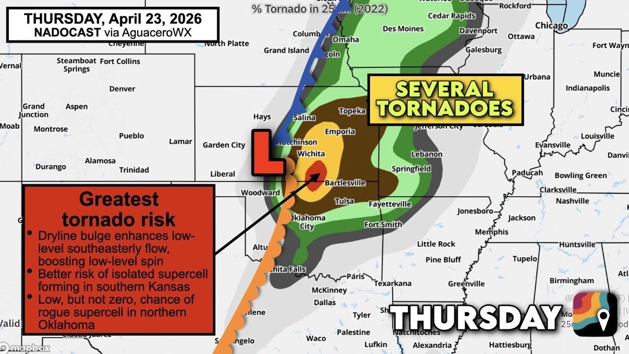
WICHITA, KS — The greatest tornado risk on Thursday, April 23, 2026 is locked onto southern Kansas along and east of I-35, where a dryline bulge and surging low-level wind shear are creating the most favorable environment for isolated tornadic supercells in the entire Thursday outlook. Current analysis identifies Wichita, Emporia, Topeka, and the southern Kansas corridor as the bullseye for several tornadoes Thursday, while communities further north should prepare for windy squall lines as the primary threat.
The low-pressure center positioned near Hutchinson is the atmospheric pivot point for Thursday’s entire severe weather setup — everything severe weather-related on Thursday rotates around this system.
The Two Distinct Threats Thursday
Thursday’s severe weather pattern splits clearly into two separate hazard profiles depending on where you are relative to the low-pressure center and the dryline.
Southern Kansas — The Tornado Zone
The tornado probability map for Thursday shows the highest concentration of tornado risk along and east of I-35 through southern Kansas. Three specific atmospheric factors are driving this elevated tornado risk in the south:
The dryline bulge — a westward protrusion of the moisture boundary — is enhancing the low-level southeasterly flow across southern Kansas, which directly boosts the low-level wind spin that tornadoes need to reach the ground. When a dryline bulge positions itself favorably relative to a surface low, it creates a localized zone of maximized wind shear that is disproportionately favorable for tornado-producing supercells compared to surrounding areas.
The risk of an isolated supercell forming in southern Kansas is identified as the better-risk scenario for today’s most significant tornado potential. A discrete supercell — a rotating storm operating without interference from neighboring storms — in this environment carries a meaningful probability of producing one or more tornadoes before the evening is over.
A low but not zero chance of a rogue supercell also exists in northern Oklahoma, particularly near the Bartlesville and Tulsa corridor where the atmospheric environment, while less favorable than southern Kansas, still supports isolated storm development.
Northern Kansas and Nebraska — The Squall Line Wind Zone
Further north, the storm mode is expected to be different and less favorable for tornadoes. Windy squall lines — fast-moving lines of thunderstorms — are the more likely storm type across northern Kansas, Nebraska, and the Iowa fringe. The primary threat in this zone shifts from tornadoes to widespread damaging straight-line winds as the squall line pushes through. Communities near Salina, Hays, Grand Island, Omaha, and Des Moines fall in this squall line wind corridor.
Thursday Tornado Risk Summary
| Factor | Detail |
|---|---|
| Greatest Tornado Risk | Southern Kansas along and east of I-35 |
| Primary Driver | Dryline bulge enhancing low-level wind spin |
| Expected Storm Mode South | Isolated tornadic supercells |
| Expected Storm Mode North | Windy squall lines |
| Rogue Supercell Risk | Northern Oklahoma — low but not zero |
| Low Pressure Center | Near Hutchinson, Kansas |
| Several Tornadoes Possible | Wichita to Topeka to Emporia corridor |
State-by-State Breakdown
Kansas — Southern Corridor The highest tornado risk in Thursday’s entire outlook sits over southern Kansas. Wichita, Emporia, Topeka, and communities along and east of I-35 are in the primary supercell environment. Current analysis supports several tornadoes being possible from isolated supercells that develop in this zone Thursday afternoon and evening. Residents across southern Kansas must have shelter plans confirmed and weather alerts active before afternoon storm initiation begins.
Kansas — Northern Corridor Salina, Hays, and northern Kansas fall in the squall line wind zone rather than the primary tornado corridor. Damaging wind gusts with the fast-moving line are the main concern here. Tornado risk is lower but not zero if any embedded rotation develops within the line.
Oklahoma — Northern Including Tulsa and Bartlesville Northern Oklahoma carries a low but not zero rogue supercell risk Thursday. The environment here is less favorable than southern Kansas but the atmosphere across Tulsa and Bartlesville is primed enough that an isolated storm development cannot be dismissed. Oklahoma City sits further south and west of the primary tornado zone but remains in the broader severe weather corridor.
Nebraska and Iowa Omaha, Grand Island, and the Nebraska and Iowa corridor fall in the squall line wind zone. Damaging wind gusts and large hail are the primary threats as the line pushes northward through these states Thursday evening.
Missouri — Including Kansas City and Springfield Kansas City and Springfield, Missouri sit on the eastern edge of Thursday’s tornado risk zone. The supercell environment extends into western Missouri, and any storm that crosses the Kansas-Missouri state line while maintaining its structure remains capable of producing a tornado.
Forecast Confidence
Confidence: Moderate for the geographic split between the tornado zone in southern Kansas and the squall line wind zone to the north. Current analysis acknowledges that the model driving this tornado probability map may be running slightly aggressive on tornado potential — meaning the actual tornado count could come in below what the model suggests. However, the fundamental setup of a dryline bulge enhancing low-level spin across southern Kansas is a physically sound and well-supported scenario. The tornado risk for Wichita, Emporia, and Topeka on Thursday is real and should be treated with full seriousness.
More tornado and severe weather coverage is always on the horizon. Stay informed at ChicagoMusicGuide.com — your source for Kansas tornado tracking and Plains severe weather coverage across the entire United States.